Property Record
6405 Nc Hwy 73 E, Mount Pleasant, NC 28124

NEARBY LISTINGS FOR SALE OR LEASE
-
-
View all Mount Pleasant listings for sale on LoopNet.com
Property Detail
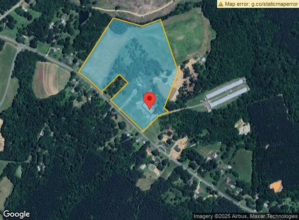
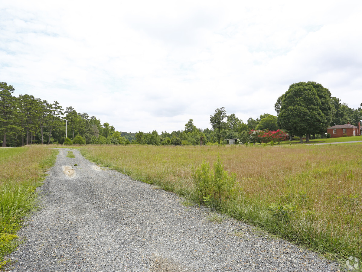
6405 Nc Hwy 73 E
5660-19-8156-0000
Mt Pleasant High School
Autorepair
NORTH SIDE HWY 73 E WITH 45' ROW
X
Cabarrus
3710566000K
North Carolina
2024
26.46 AC
2024
Cabarrus County
041702
Charlotte
6,394 SF
Charlotte-Concord-Gastonia, NC-SC
DEMOGRAPHICS near 6405 Nc Hwy 73 E
1 Mile
3 Mile
5 Mile
2024 Total Population
461
7,652
16,425
2029 Population
517
8,584
18,450
Pop Growth 2024-2029
+ 12.15%
+ 12.18%
+ 12.33%
Average Age
44
42
42
2024 Total Households
184
2,884
6,155
HH Growth 2024-2029
+ 10.33%
+ 10.78%
+ 10.90%
Median Household Inc
$64,107
$71,701
$72,652
Avg Household Size
2.50
2.60
2.60
2024 Avg HH Vehicles
3.00
2.00
2.00
Median Home Value
$292,307
$283,502
$281,901
Median Year Built
1976
1983
1984
Nearby Places
- Restaurants
- Banks
- Shops
- Fitness
- Groceries
PUBLIC TRANSPORTATION
AIRPORT
Concord-Padgett Regional
DRIVE
WALK
Distance
Concord-Padgett Regional
31 min
19.2 mi
Freight Ports
Port of Wilmington
DRIVE
WALK
Distance
Port of Wilmington
247 min
194.0 mi
SALE & LEASE HISTORY
LISTING DATE
SALE/LEASE

Aug 03, 2018
For Sale
Nearby Properties
Address
Land Use
TOTAL SIZE
Lot Size
Zoning
Address
Land Use
TOTAL SIZE
Lot Size
Zoning
46,811 SF
68.68 AC
PID
Address
Land Use
TOTAL SIZE
Lot Size
Zoning
158,606 SF
53.21 AC
O-I
Address
Land Use
TOTAL SIZE
Lot Size
Zoning
146,052 SF
98.84 AC
CR
Address
Land Use
TOTAL SIZE
Lot Size
Zoning
40,632 SF
28.71 AC
PID
Address
Land Use
TOTAL SIZE
Lot Size
Zoning
71,326 SF
32.20 AC
O-I
Address
Land Use
TOTAL SIZE
Lot Size
Zoning
8,116 SF
2.03 AC
RM-1
Address
Land Use
TOTAL SIZE
Lot Size
Zoning
16,600 SF
9.43 AC
RH-CZ
Address
Land Use
TOTAL SIZE
Lot Size
Zoning
9,383 SF
10.28 AC
O-I
Address
Land Use
TOTAL SIZE
Lot Size
Zoning
17,267 SF
4.80 AC
RH
Address
Land Use
TOTAL SIZE
Lot Size
Zoning
14,264 SF
12.43 AC
CR
Address
Land Use
TOTAL SIZE
Lot Size
Zoning
11,741 SF
106.41 AC
CR
Address
Land Use
TOTAL SIZE
Lot Size
Zoning
36,642 SF
22.18 AC
O-I
Address
Land Use
TOTAL SIZE
Lot Size
Zoning
46,602 SF
7.19 AC
C-1
Address
Land Use
TOTAL SIZE
Lot Size
Zoning
1,140 SF
29.87 AC
I-1
Address
Land Use
TOTAL SIZE
Lot Size
Zoning
68,128 SF
13.82 AC
C-1
Address
Land Use
TOTAL SIZE
Lot Size
Zoning
7,174 SF
3.46 AC
CR
Address
Land Use
TOTAL SIZE
Lot Size
Zoning
8,288 SF
1.06 AC
O-I
Address
Land Use
TOTAL SIZE
Lot Size
Zoning
10,525 SF
2.36 AC
O-I
Address
Land Use
TOTAL SIZE
Lot Size
Zoning
5,087 SF
3.81 AC
RH
Address
Land Use
TOTAL SIZE
Lot Size
Zoning
11,780 SF
1.08 AC
C-1
Address
Land Use
TOTAL SIZE
Lot Size
Zoning
8,300 SF
1.90 AC
C-1
Address
Land Use
TOTAL SIZE
Lot Size
Zoning
8,619 SF
0.90 AC
C-2
Address
Land Use
TOTAL SIZE
Lot Size
Zoning
1,932 SF
2.38 AC
CUC-2
Address
Land Use
TOTAL SIZE
Lot Size
Zoning
4,490 SF
1.68 AC
C-1
Address
Land Use
TOTAL SIZE
Lot Size
Zoning
8,212 SF
1.33 AC
O-I
Address
Land Use
TOTAL SIZE
Lot Size
Zoning
83,794 SF
3.14 AC
I-1
Address
Land Use
TOTAL SIZE
Lot Size
Zoning
13,056 SF
0.85 AC
O-I
Address
Land Use
TOTAL SIZE
Lot Size
Zoning
7,200 SF
2.03 AC
RL
Address
Land Use
TOTAL SIZE
Lot Size
Zoning
30 AC
LC
The World's #1 Commercial Real Estate Marketplace
Connect with us
© 2025 CoStar Group
The information above has been obtained from sources believed reliable. While we do not doubt its accuracy we have not verified it and make no guarantee, warranty or representation about it. It is your responsibility to independently confirm its accuracy and completeness. Any projections, opinions, assumptions, or estimates used are for example only and do not represent the current or future performance of the property. The value of this transaction to you depends on tax and other factors which should be evaluated by your tax, financial, and legal advisors. You and your advisors should conduct a careful, independent investigation of the property to determine to your satisfaction the suitability of the property for your needs.