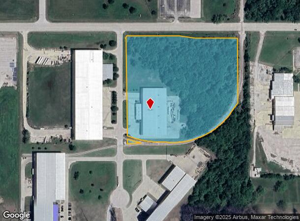
Property Record
6433 N Erie Ave, Tulsa, OK 74117
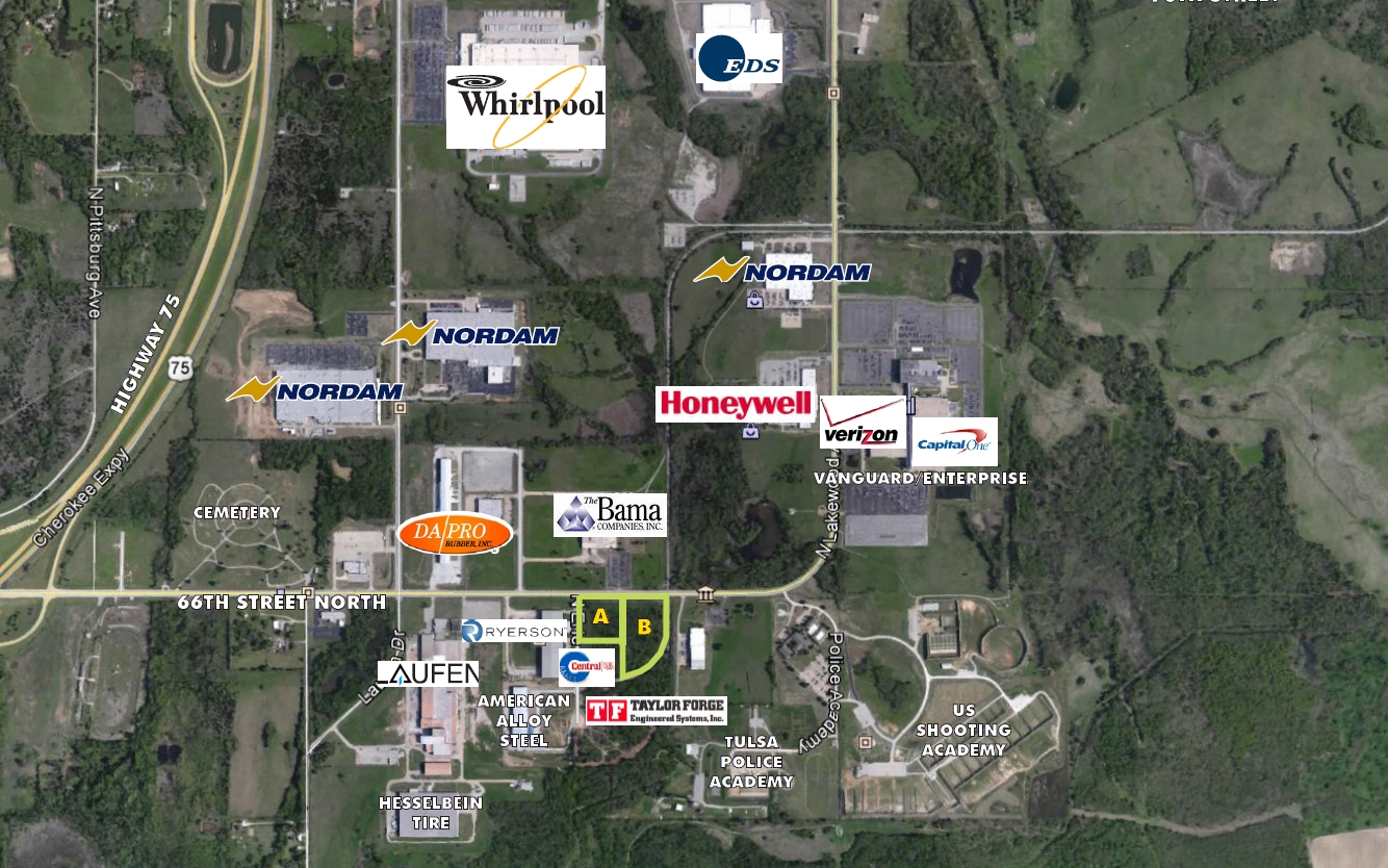
NEARBY LISTINGS FOR SALE OR LEASE
Property Detail
6433 N Erie Ave
Tulsa, OK
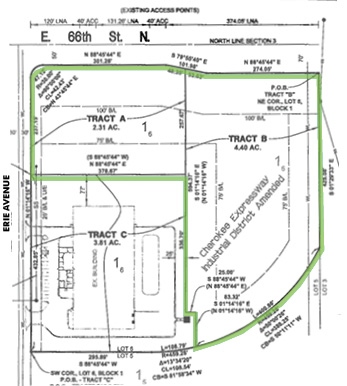
Cherokee Expressway Ind Dist Amd Rsb L2
61051-03-03-39540
LT 6 BLK 1
Lightindustrial
Tulsa
X
Oklahoma
40143C0231L
6
2023
10.44 AC
2024
Northeast
005808
Tulsa
52,000 SF
DEMOGRAPHICS near 6433 N Erie Ave
1 Mile
3 Mile
5 Mile
2024 Total Population
26
5,561
50,761
2029 Population
27
5,869
53,127
Pop Growth 2024-2029
+ 3.85%
+ 5.54%
+ 4.66%
Average Age
37
39
37
2024 Total Households
9
1,985
18,600
HH Growth 2024-2029
0.00%
+ 5.64%
+ 4.67%
Median Household Inc
$137,500
$68,882
$46,189
Avg Household Size
2.90
2.70
2.60
2024 Avg HH Vehicles
3.00
2.00
2.00
Median Home Value
$325,000
$255,431
$132,599
Median Year Built
2011
1995
1974
Nearby Places
- Restaurants
- Banks
- Shops
- Fitness
- Groceries
PUBLIC TRANSPORTATION
AIRPORT
Tulsa International
DRIVE
WALK
Distance
Tulsa International
14 min
8.5 mi
Freight Ports
Tulsa Port Of Catoosa
DRIVE
WALK
Distance
Tulsa Port Of Catoosa
22 min
14.1 mi
SALE & LEASE HISTORY
LISTING DATE
SALE/LEASE

Sep 24, 2016
For Sale
Nearby Properties
Address
Land Use
TOTAL SIZE
Lot Size
Zoning
Address
Land Use
TOTAL SIZE
Lot Size
Zoning
3,235,512 SF
71.56 AC
IM
Address
Land Use
TOTAL SIZE
Lot Size
Zoning
873,896 SF
50 AC
IM
Address
Land Use
TOTAL SIZE
Lot Size
Zoning
65,354 SF
41.54 AC
AG
Address
Land Use
TOTAL SIZE
Lot Size
Zoning
429,912 SF
59.57 AC
IM
Address
Land Use
TOTAL SIZE
Lot Size
Zoning
63,108 SF
33.82 AC
AG
Address
Land Use
TOTAL SIZE
Lot Size
Zoning
42,665 SF
493.63 AC
RS3
Address
Land Use
TOTAL SIZE
Lot Size
Zoning
457,823 SF
25.72 AC
IM
Address
Land Use
TOTAL SIZE
Lot Size
Zoning
67,909 SF
48.73 AC
IM
Address
Land Use
TOTAL SIZE
Lot Size
Zoning
16,196 SF
9.73 AC
IL
Address
Land Use
TOTAL SIZE
Lot Size
Zoning
513.99 AC
RS3
Address
Land Use
TOTAL SIZE
Lot Size
Zoning
36,450 SF
30.52 AC
RS3
Address
Land Use
TOTAL SIZE
Lot Size
Zoning
32,300 SF
20.88 AC
NCU
Address
Land Use
TOTAL SIZE
Lot Size
Zoning
859,108 SF
86.24 AC
IM
Address
Land Use
TOTAL SIZE
Lot Size
Zoning
53.24 AC
IM
Address
Land Use
TOTAL SIZE
Lot Size
Zoning
229,485 SF
16.77 AC
IM
Address
Land Use
TOTAL SIZE
Lot Size
Zoning
5,670 SF
96.05 AC
AG
Address
Land Use
TOTAL SIZE
Lot Size
Zoning
473,599 SF
56.42 AC
IM
Address
Land Use
TOTAL SIZE
Lot Size
Zoning
29,065 SF
111.30 AC
RS
Address
Land Use
TOTAL SIZE
Lot Size
Zoning
419,821 SF
38.38 AC
IM
Address
Land Use
TOTAL SIZE
Lot Size
Zoning
22,887 SF
3.53 AC
AG
Address
Land Use
TOTAL SIZE
Lot Size
Zoning
6,800 SF
347.72 AC
RS3
Address
Land Use
TOTAL SIZE
Lot Size
Zoning
9,566 SF
8.26 AC
IL
Address
Land Use
TOTAL SIZE
Lot Size
Zoning
137,320 SF
40.12 AC
IM
Address
Land Use
TOTAL SIZE
Lot Size
Zoning
175,614 SF
33.58 AC
IM
Address
Land Use
TOTAL SIZE
Lot Size
Zoning
14,836 SF
9.39 AC
AGR
Address
Land Use
TOTAL SIZE
Lot Size
Zoning
1 SF
228.69 AC
AG
Address
Land Use
TOTAL SIZE
Lot Size
Zoning
180,693 SF
39.13 AC
IM
Address
Land Use
TOTAL SIZE
Lot Size
Zoning
85,489 SF
17.99 AC
IM
Address
Land Use
TOTAL SIZE
Lot Size
Zoning
1,200 SF
38.79 AC
AG
Address
Land Use
TOTAL SIZE
Lot Size
Zoning
136,660 SF
29.88 AC
IM
The World's #1 Commercial Real Estate Marketplace
Connect with us
© 2025 CoStar Group
The information above has been obtained from sources believed reliable. While we do not doubt its accuracy we have not verified it and make no guarantee, warranty or representation about it. It is your responsibility to independently confirm its accuracy and completeness. Any projections, opinions, assumptions, or estimates used are for example only and do not represent the current or future performance of the property. The value of this transaction to you depends on tax and other factors which should be evaluated by your tax, financial, and legal advisors. You and your advisors should conduct a careful, independent investigation of the property to determine to your satisfaction the suitability of the property for your needs.