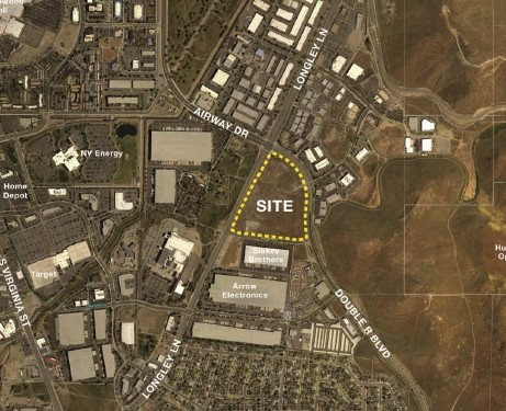
Property Record
645 Innovation Dr, Reno, NV 89511

NEARBY LISTINGS FOR SALE OR LEASE
Property Detail
645 Innovation Dr
Reno, NV
_Unspecified
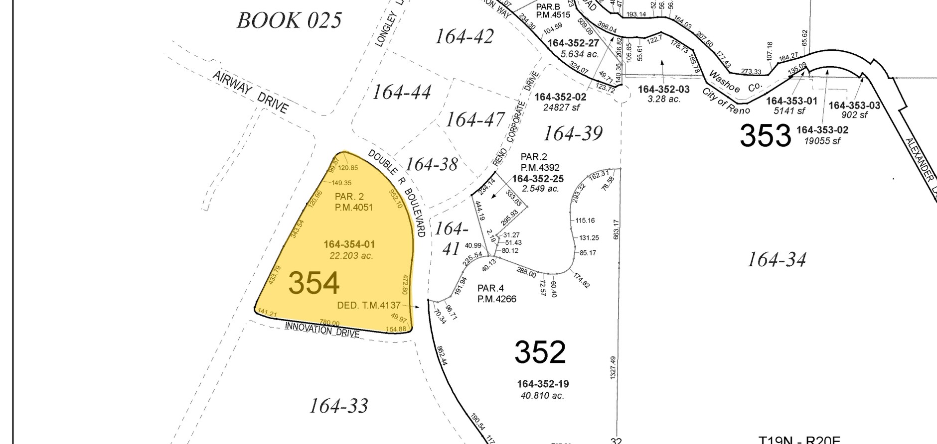
164-354-01
PM 4051 LOT 2
Commercialnec
Washoe
X
Nevada
32031C3234G
2
2024
22.20 AC
2024
Meadowood
002215
Reno/Sparks
390,799 SF
DEMOGRAPHICS near 645 Innovation Dr
1 Mile
3 Mile
5 Mile
2024 Total Population
6,506
70,235
149,929
2029 Population
6,811
74,122
157,991
Pop Growth 2024-2029
+ 4.69%
+ 5.53%
+ 5.38%
Average Age
38
40
41
2024 Total Households
2,953
29,262
64,499
HH Growth 2024-2029
+ 4.88%
+ 5.67%
+ 5.44%
Median Household Inc
$64,256
$70,494
$75,498
Avg Household Size
2.20
2.30
2.30
2024 Avg HH Vehicles
2.00
2.00
2.00
Median Home Value
$332,037
$457,606
$555,499
Median Year Built
1982
1986
1985
Nearby Places
- Restaurants
- Banks
- Shops
- Fitness
- Groceries
PUBLIC TRANSPORTATION
COMMUTER RAIL
Reno (California Zephyr - Amtrak)
DRIVE
WALK
Distance
Reno (California Zephyr - Amtrak)
13 min
6.4 mi
AIRPORT
Reno/Tahoe International
DRIVE
WALK
Distance
Reno/Tahoe International
25 min
6.9 mi
Freight Ports
Port of Stockton
DRIVE
WALK
Distance
Port of Stockton
217 min
186.1 mi
Nearby Properties
Address
Land Use
TOTAL SIZE
Lot Size
Zoning
Address
Land Use
TOTAL SIZE
Lot Size
Zoning
1,638,272 SF
17.11 AC
MU
Address
Land Use
TOTAL SIZE
Lot Size
Zoning
750,062 SF
1,131.28 AC
MA
Address
Land Use
TOTAL SIZE
Lot Size
Zoning
799,762 SF
13.30 AC
MU
Address
Land Use
TOTAL SIZE
Lot Size
Zoning
1,051,043 SF
78.81 AC
PD
Address
Land Use
TOTAL SIZE
Lot Size
Zoning
759,161 SF
37.37 AC
MU
Address
Land Use
TOTAL SIZE
Lot Size
Zoning
425,118 SF
30.37 AC
IC
Address
Land Use
TOTAL SIZE
Lot Size
Zoning
902,415 SF
52.71 AC
MA
Address
Land Use
TOTAL SIZE
Lot Size
Zoning
451,635 SF
15 AC
PD
Address
Land Use
TOTAL SIZE
Lot Size
Zoning
389,745 SF
15.17 AC
MS
Address
Land Use
TOTAL SIZE
Lot Size
Zoning
500,079 SF
45.66 AC
MU
Address
Land Use
TOTAL SIZE
Lot Size
Zoning
327,867 SF
12.11 AC
PD
Address
Land Use
TOTAL SIZE
Lot Size
Zoning
271,546 SF
20.62 AC
PD
Address
Land Use
TOTAL SIZE
Lot Size
Zoning
342,019 SF
23.32 AC
MF14
Address
Land Use
TOTAL SIZE
Lot Size
Zoning
365,634 SF
19.70 AC
MF21
Address
Land Use
TOTAL SIZE
Lot Size
Zoning
366,641 SF
37.91 AC
MA
Address
Land Use
TOTAL SIZE
Lot Size
Zoning
151,254 SF
48.11 AC
MDS
Address
Land Use
TOTAL SIZE
Lot Size
Zoning
187,900 SF
14.83 AC
PD
Address
Land Use
TOTAL SIZE
Lot Size
Zoning
231,329 SF
8.37 AC
GC
Address
Land Use
TOTAL SIZE
Lot Size
Zoning
212,660 SF
5.21 AC
MS
Address
Land Use
TOTAL SIZE
Lot Size
Zoning
434,330 SF
12.07 AC
MS
Address
Land Use
TOTAL SIZE
Lot Size
Zoning
591,000 SF
5.46 AC
MU
Address
Land Use
TOTAL SIZE
Lot Size
Zoning
149,324 SF
4.34 AC
PD
Address
Land Use
TOTAL SIZE
Lot Size
Zoning
270,950 SF
14.86 AC
IC
Address
Land Use
TOTAL SIZE
Lot Size
Zoning
176,666 SF
7.10 AC
PD
Address
Land Use
TOTAL SIZE
Lot Size
Zoning
80,970 SF
5.28 AC
MS
Address
Land Use
TOTAL SIZE
Lot Size
Zoning
381,852 SF
18.60 AC
GC
Address
Land Use
TOTAL SIZE
Lot Size
Zoning
205,285 SF
19.70 AC
MS
Address
Land Use
TOTAL SIZE
Lot Size
Zoning
452,732 SF
19.30 AC
IC
Address
Land Use
TOTAL SIZE
Lot Size
Zoning
394,767 SF
23.50 AC
PD
The World's #1 Commercial Real Estate Marketplace
Connect with us
© 2025 CoStar Group
The information above has been obtained from sources believed reliable. While we do not doubt its accuracy we have not verified it and make no guarantee, warranty or representation about it. It is your responsibility to independently confirm its accuracy and completeness. Any projections, opinions, assumptions, or estimates used are for example only and do not represent the current or future performance of the property. The value of this transaction to you depends on tax and other factors which should be evaluated by your tax, financial, and legal advisors. You and your advisors should conduct a careful, independent investigation of the property to determine to your satisfaction the suitability of the property for your needs.