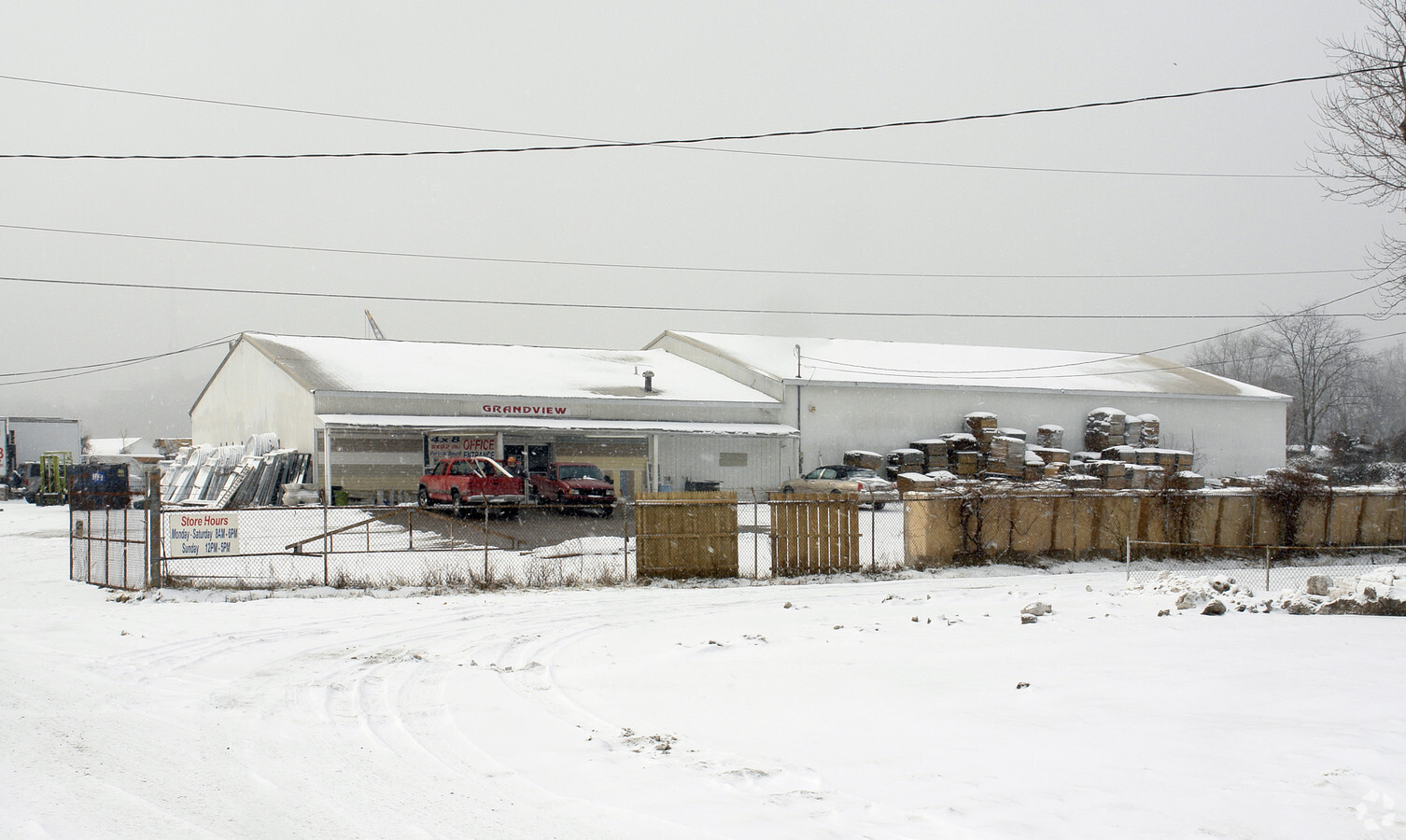
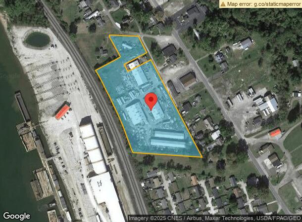
Property Record
65 Twp Rd N, South Point, OH 45680

NEARBY LISTINGS FOR SALE OR LEASE
Property Detail
65 Twp Rd N
15-120-1800-000
Brubaker Land
Commercialnec
17-02-19 1 PT DANIEL BRUBAKER LAND BET. PLUMMER 0005.58A
X
Lawrence
21019C0078E
Ohio
2023
5.58 AC
2023
Lawrence County
051101
Huntington/Ashland
27,672 SF
Huntington-Ashland, WV-KY-OH
DEMOGRAPHICS near 65 Twp Rd N
1 Mile
3 Mile
5 Mile
2024 Total Population
1,915
22,101
47,763
2029 Population
1,893
21,817
46,945
Pop Growth 2024-2029
(1.15%)
(1.29%)
(1.71%)
Average Age
39
41
42
2024 Total Households
900
9,300
19,889
HH Growth 2024-2029
(1.00%)
(1.19%)
(1.62%)
Median Household Inc
$24,523
$46,601
$47,826
Avg Household Size
2.00
2.30
2.30
2024 Avg HH Vehicles
1.00
2.00
2.00
Median Home Value
$86,415
$115,138
$113,460
Median Year Built
1971
1963
1966
Nearby Places
- Restaurants
- Banks
- Shops
- Fitness
- Groceries
PUBLIC TRANSPORTATION
COMMUTER RAIL
Ashland Amtrak Station (Cardinal - Amtrak)
DRIVE
WALK
Distance
Ashland Amtrak Station (Cardinal - Amtrak)
6 min
3.4 mi
AIRPORT
Tri-State/Milton J Ferguson Field
DRIVE
WALK
Distance
Tri-State/Milton J Ferguson Field
26 min
15.3 mi
Freight Ports
Port of Toledo
DRIVE
WALK
Distance
Port of Toledo
335 min
259.4 mi
Nearby Properties
Address
Land Use
TOTAL SIZE
Lot Size
Zoning
Address
Land Use
TOTAL SIZE
Lot Size
Zoning
6.96 AC
Z02
Address
Land Use
TOTAL SIZE
Lot Size
Zoning
36.49 AC
OTHER
Address
Land Use
TOTAL SIZE
Lot Size
Zoning
29.92 AC
Z02
Address
Land Use
TOTAL SIZE
Lot Size
Zoning
0.99 AC
Z02
Address
Land Use
TOTAL SIZE
Lot Size
Zoning
16.29 AC
COMMERCIAL
Address
Land Use
TOTAL SIZE
Lot Size
Zoning
116,640 SF
0.97 AC
COMMERCIAL
Address
Land Use
TOTAL SIZE
Lot Size
Zoning
91,786 SF
2.93 AC
Address
Land Use
TOTAL SIZE
Lot Size
Zoning
0.73 AC
Z02
Address
Land Use
TOTAL SIZE
Lot Size
Zoning
123,920 SF
6.81 AC
Address
Land Use
TOTAL SIZE
Lot Size
Zoning
Address
Land Use
TOTAL SIZE
Lot Size
Zoning
1.67 AC
RESIDENTIA
Address
Land Use
TOTAL SIZE
Lot Size
Zoning
1.95 AC
COMMERCIAL
Address
Land Use
TOTAL SIZE
Lot Size
Zoning
141 AC
COMMERCIAL
Address
Land Use
TOTAL SIZE
Lot Size
Zoning
47,107 SF
4.67 AC
Address
Land Use
TOTAL SIZE
Lot Size
Zoning
8,364 SF
3 AC
Z02
Address
Land Use
TOTAL SIZE
Lot Size
Zoning
1.46 AC
COMMERCIAL
Address
Land Use
TOTAL SIZE
Lot Size
Zoning
Address
Land Use
TOTAL SIZE
Lot Size
Zoning
0.20 AC
Z02
Address
Land Use
TOTAL SIZE
Lot Size
Zoning
3.50 AC
Z02
Address
Land Use
TOTAL SIZE
Lot Size
Zoning
1,920 SF
33.30 AC
Z03
Address
Land Use
TOTAL SIZE
Lot Size
Zoning
0.57 AC
COMMERCIAL
Address
Land Use
TOTAL SIZE
Lot Size
Zoning
126,716 SF
10.60 AC
Address
Land Use
TOTAL SIZE
Lot Size
Zoning
16,632 SF
1.07 AC
COMMERCIAL
Address
Land Use
TOTAL SIZE
Lot Size
Zoning
54.65 AC
Address
Land Use
TOTAL SIZE
Lot Size
Zoning
66,600 SF
1.35 AC
OTHER
Address
Land Use
TOTAL SIZE
Lot Size
Zoning
6,678 SF
8.57 AC
COMMERCIAL
Address
Land Use
TOTAL SIZE
Lot Size
Zoning
4 AC
Z01
Address
Land Use
TOTAL SIZE
Lot Size
Zoning
0.48 AC
COMMERCIAL
Address
Land Use
TOTAL SIZE
Lot Size
Zoning
7.76 AC
Z03
Address
Land Use
TOTAL SIZE
Lot Size
Zoning
96,405 SF
1.40 AC
COMMERCIAL
The World's #1 Commercial Real Estate Marketplace
Connect with us
© 2025 CoStar Group
The information above has been obtained from sources believed reliable. While we do not doubt its accuracy we have not verified it and make no guarantee, warranty or representation about it. It is your responsibility to independently confirm its accuracy and completeness. Any projections, opinions, assumptions, or estimates used are for example only and do not represent the current or future performance of the property. The value of this transaction to you depends on tax and other factors which should be evaluated by your tax, financial, and legal advisors. You and your advisors should conduct a careful, independent investigation of the property to determine to your satisfaction the suitability of the property for your needs.