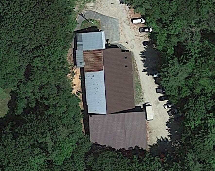
Property Record
65 W Main St, Bradford, NH 03221

NEARBY LISTINGS FOR SALE OR LEASE
-
-
View all Bradford listings for lease on LoopNet.com
Property Detail
65 W Main St
BRAD-000016-000000-000115
Merrimack
Industrialgeneral
New Hampshire
A
115
33013C0265E
1.26 AC
2023
Concord/New Hampshire North Area
2023
Other Market Areas
040501
Concord, NH
9,582 SF
DEMOGRAPHICS near 65 W Main St
1 Mile
3 Mile
5 Mile
2024 Total Population
608
2,251
3,947
2029 Population
644
2,377
4,149
Pop Growth 2024-2029
+ 5.92%
+ 5.60%
+ 5.12%
Average Age
45
46
45
2024 Total Households
247
933
1,631
HH Growth 2024-2029
+ 5.67%
+ 5.47%
+ 4.97%
Median Household Inc
$79,276
$88,076
$92,898
Avg Household Size
2.50
2.40
2.40
2024 Avg HH Vehicles
2.00
2.00
2.00
Median Home Value
$346,739
$366,486
$367,799
Median Year Built
1965
1972
1973
Nearby Places
- Restaurants
- Banks
- Shops
- Fitness
- Groceries
SALE & LEASE HISTORY
LISTING DATE
SALE/LEASE

Mar 03, 2021
For Lease
Mar 03, 2021
For Sale
Aug 06, 2021
For Lease
Aug 06, 2021
For Sale
Nearby Properties
Address
Land Use
TOTAL SIZE
Lot Size
Zoning
Address
Land Use
TOTAL SIZE
Lot Size
Zoning
6,232 SF
46 AC
RESIDE
Address
Land Use
TOTAL SIZE
Lot Size
Zoning
26,135 SF
26.10 AC
RES/BU
Address
Land Use
TOTAL SIZE
Lot Size
Zoning
1,485 SF
15.44 AC
Address
Land Use
TOTAL SIZE
Lot Size
Zoning
1,318 SF
2.74 AC
RESIDE
Address
Land Use
TOTAL SIZE
Lot Size
Zoning
2,352 SF
1.98 AC
BUSINE
Address
Land Use
TOTAL SIZE
Lot Size
Zoning
5,083 SF
228 AC
RESIDE
Address
Land Use
TOTAL SIZE
Lot Size
Zoning
22.50 AC
RES/BU
Address
Land Use
TOTAL SIZE
Lot Size
Zoning
15,000 SF
6.04 AC
RESIDE
Address
Land Use
TOTAL SIZE
Lot Size
Zoning
2 AC
RES/BU
Address
Land Use
TOTAL SIZE
Lot Size
Zoning
26.70 AC
RURAL
Address
Land Use
TOTAL SIZE
Lot Size
Zoning
10,023 SF
15.20 AC
RES/BU
Address
Land Use
TOTAL SIZE
Lot Size
Zoning
8,841 SF
0.69 AC
RES/BU
Address
Land Use
TOTAL SIZE
Lot Size
Zoning
14.30 AC
RES/BU
Address
Land Use
TOTAL SIZE
Lot Size
Zoning
10,503 SF
11.91 AC
RURAL
Address
Land Use
TOTAL SIZE
Lot Size
Zoning
5,332 SF
1.30 AC
RES/BU
Address
Land Use
TOTAL SIZE
Lot Size
Zoning
13,884 SF
2.09 AC
Address
Land Use
TOTAL SIZE
Lot Size
Zoning
6 AC
RURAL
Address
Land Use
TOTAL SIZE
Lot Size
Zoning
3,383 SF
0.24 AC
RES/BU
Address
Land Use
TOTAL SIZE
Lot Size
Zoning
7,713 SF
1.50 AC
RES/BU
Address
Land Use
TOTAL SIZE
Lot Size
Zoning
5,000 SF
72 AC
BUSINE
Address
Land Use
TOTAL SIZE
Lot Size
Zoning
0.78 AC
RES/BU
Address
Land Use
TOTAL SIZE
Lot Size
Zoning
13,680 SF
5.60 AC
RES/BU
Address
Land Use
TOTAL SIZE
Lot Size
Zoning
4,611 SF
11.80 AC
BUSINE
Address
Land Use
TOTAL SIZE
Lot Size
Zoning
8,570 SF
1.70 AC
RES/BU
Address
Land Use
TOTAL SIZE
Lot Size
Zoning
4.03 AC
RURAL
Address
Land Use
TOTAL SIZE
Lot Size
Zoning
5,293 SF
1.20 AC
RES/BU
Address
Land Use
TOTAL SIZE
Lot Size
Zoning
5,012 SF
6.14 AC
RESIDE
Address
Land Use
TOTAL SIZE
Lot Size
Zoning
4,621 SF
1.20 AC
RES/BU
Address
Land Use
TOTAL SIZE
Lot Size
Zoning
2,648 SF
2.20 AC
RESIDE
Address
Land Use
TOTAL SIZE
Lot Size
Zoning
4,903 SF
0.83 AC
RES/BU
Start a new search to find other properties for sale or lease
Connect with us
© 2024 CoStar Group
The information above has been obtained from sources believed reliable. While we do not doubt its accuracy we have not verified it and make no guarantee, warranty or representation about it. It is your responsibility to independently confirm its accuracy and completeness. Any projections, opinions, assumptions, or estimates used are for example only and do not represent the current or future performance of the property. The value of this transaction to you depends on tax and other factors which should be evaluated by your tax, financial, and legal advisors. You and your advisors should conduct a careful, independent investigation of the property to determine to your satisfaction the suitability of the property for your needs.