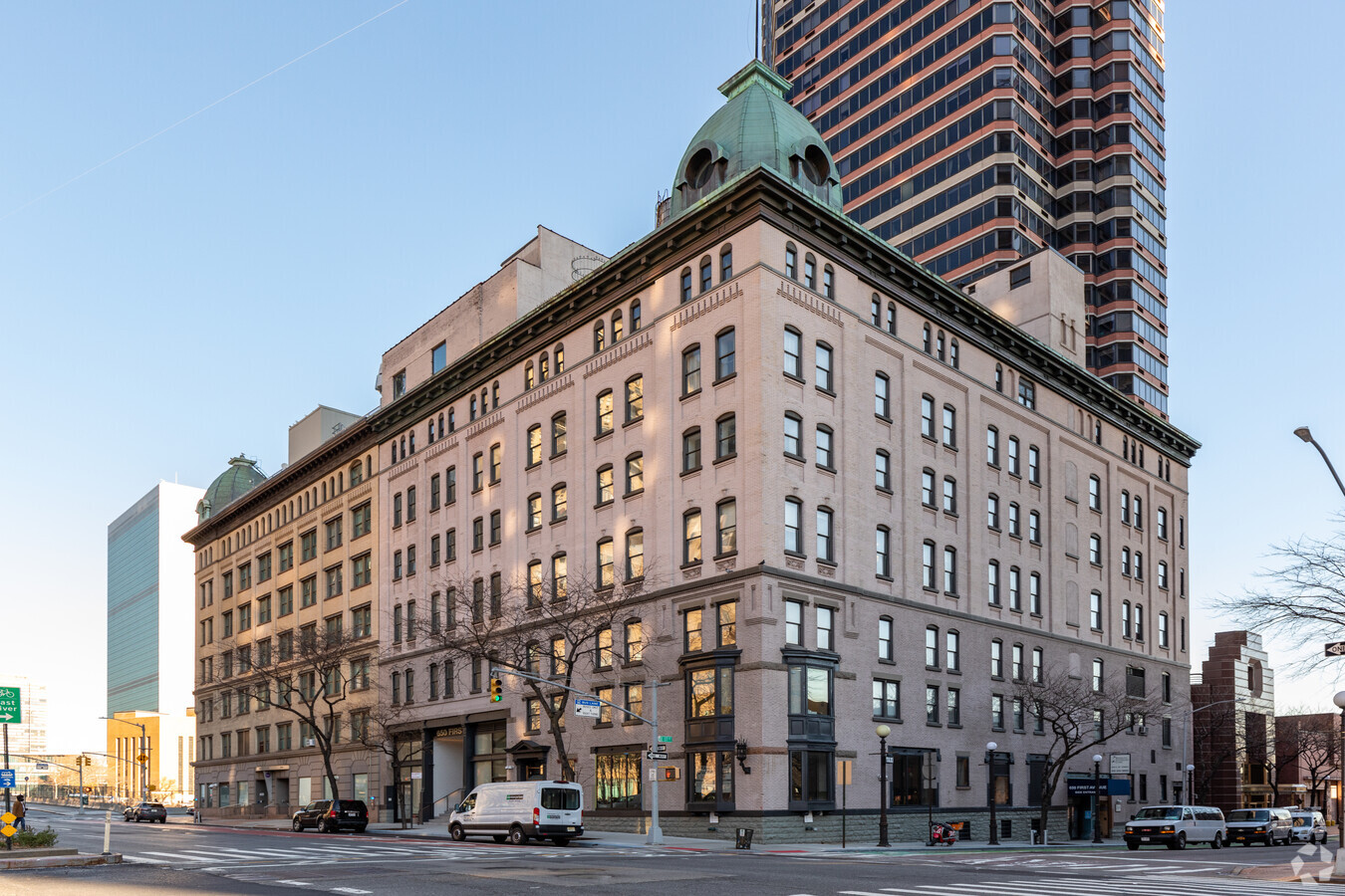
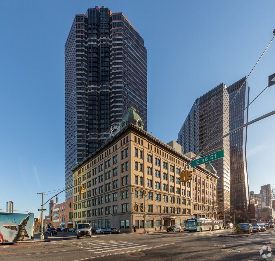
Property Record
650 1St Ave, New York, NY 10016

NEARBY LISTINGS FOR SALE OR LEASE
Property Detail
650 1St Ave
New York-Jersey City-White Plains, NY-NJ
Manhattan
0969-0001
New York
Officebuilding
0.27 AC
X
Murray Hill
3604970201F
New York City
98,400 SF
DEMOGRAPHICS near 650 1St Ave
1 Mile
3 Mile
5 Mile
2024 Total Population
167,743
1,288,531
2,994,358
2029 Population
156,356
1,206,997
2,818,521
Pop Growth 2024-2029
(6.79%)
(6.33%)
(5.87%)
Average Age
40
41
39
2024 Total Households
91,892
647,726
1,335,313
HH Growth 2024-2029
(7.01%)
(6.61%)
(6.21%)
Median Household Inc
$125,723
$106,089
$92,168
Avg Household Size
1.70
1.90
2.10
2024 Avg HH Vehicles
.00
.00
.00
Median Home Value
$893,108
$992,299
$887,855
Median Year Built
1964
1957
1955
Nearby Places
- Restaurants
- Banks
- Shops
- Fitness
- Groceries
PUBLIC TRANSPORTATION
TRANSIT/SUBWAY
33 Street (4,6 Line) (4 - New York MTA Subway (The Subway), 6 - New York MTA Subway (The Subway))
DRIVE
WALK
Distance
33 Street (4,6 Line) (4 - New York MTA Subway (The Subway), 6 - New York MTA Subway (The Subway))
2 min
12 min
0.7 mi
Grand Central-42 Street (4 - New York MTA Subway (The Subway), 42 St Shuttle - New York MTA Subway (The Subway), 5 - New York MTA Subway (The Subway), 6 - New York MTA Subway (The Subway), 7 - New York MTA Subway (The Subway))
DRIVE
WALK
Distance
Grand Central-42 Street (4 - New York MTA Subway (The Subway), 42 St Shuttle - New York MTA Subway (The Subway), 5 - New York MTA Subway (The Subway), 6 - New York MTA Subway (The Subway), 7 - New York MTA Subway (The Subway))
2 min
12 min
0.7 mi
Grand Central-42 St (42 St Shuttle - MTA New York City Transit)
DRIVE
WALK
Distance
Grand Central-42 St (42 St Shuttle - MTA New York City Transit)
2 min
15 min
0.8 mi
5 Avenue-Bryant Park (7 - New York MTA Subway (The Subway))
DRIVE
WALK
Distance
5 Avenue-Bryant Park (7 - New York MTA Subway (The Subway))
3 min
17 min
0.9 mi
28 Street (4,6 Line) (4 - New York MTA Subway (The Subway), 6 - New York MTA Subway (The Subway))
DRIVE
WALK
Distance
28 Street (4,6 Line) (4 - New York MTA Subway (The Subway), 6 - New York MTA Subway (The Subway))
3 min
17 min
0.9 mi
COMMUTER RAIL
Grand Central Terminal (Harlem Line - Metro-North Commuter Railroad Company (Metro-North), Hudson Line - Metro-North Commuter Railroad Company (Metro-North), New Haven Line - Metro-North Commuter Railroad Company (Metro-North))
DRIVE
WALK
Distance
Grand Central Terminal (Harlem Line - Metro-North Commuter Railroad Company (Metro-North), Hudson Line - Metro-North Commuter Railroad Company (Metro-North), New Haven Line - Metro-North Commuter Railroad Company (Metro-North))
3 min
14 min
0.8 mi
Grand Central (Babylon Branch - Long Island Rail Road, Far Rockaway Branch - Long Island Rail Road, Hempstead Branch - Long Island Rail Road, Port Jefferson Branch - Long Island Rail Road, Port Washington Branch - Long Island Rail Road)
DRIVE
WALK
Distance
Grand Central (Babylon Branch - Long Island Rail Road, Far Rockaway Branch - Long Island Rail Road, Hempstead Branch - Long Island Rail Road, Port Jefferson Branch - Long Island Rail Road, Port Washington Branch - Long Island Rail Road)
3 min
18 min
1.0 mi
AIRPORT
Laguardia
DRIVE
WALK
Distance
Laguardia
16 min
8.2 mi
Newark Liberty International
DRIVE
WALK
Distance
Newark Liberty International
21 min
15.1 mi
John F Kennedy International
DRIVE
WALK
Distance
John F Kennedy International
24 min
16.3 mi
Freight Ports
NY - Red Hook Container Terminal
DRIVE
WALK
Distance
NY - Red Hook Container Terminal
16 min
7.0 mi
SALE & LEASE HISTORY
LISTING DATE
SALE/LEASE

Sep 24, 2016
For Lease
Sep 24, 2016
For Lease
Sep 07, 2022
For Lease
Jan 03, 2022
For Sale
Aug 14, 2019
For Lease
Nearby Properties
Address
Land Use
TOTAL SIZE
Lot Size
Zoning
Address
Land Use
TOTAL SIZE
Lot Size
Zoning
4,060,596 SF
22.09 AC
M2-3
Address
Land Use
TOTAL SIZE
Lot Size
Zoning
1,783,434 SF
1.94 AC
C5-3
Address
Land Use
TOTAL SIZE
Lot Size
Zoning
2,245,112 SF
2.02 AC
C6-6
Address
Land Use
TOTAL SIZE
Lot Size
Zoning
2,521,850 SF
1.59 AC
C6-4
Address
Land Use
TOTAL SIZE
Lot Size
Zoning
2,221,336 SF
1.55 AC
C6-4
Address
Land Use
TOTAL SIZE
Lot Size
Zoning
2,161,994 SF
3.79 AC
M1-5
Address
Land Use
TOTAL SIZE
Lot Size
Zoning
2,636,182 SF
2.35 AC
C65.5
Address
Land Use
TOTAL SIZE
Lot Size
Zoning
2,354,289 SF
3.96 AC
C6-4
Address
Land Use
TOTAL SIZE
Lot Size
Zoning
1,678,135 SF
1.01 AC
C5-3
Address
Land Use
TOTAL SIZE
Lot Size
Zoning
2,734,038 SF
4.24 AC
C52.5
Address
Land Use
TOTAL SIZE
Lot Size
Zoning
1,897,491 SF
2.06 AC
C52.5
Address
Land Use
TOTAL SIZE
Lot Size
Zoning
1,638,259 SF
1.42 AC
C52.5
Address
Land Use
TOTAL SIZE
Lot Size
Zoning
1,233,684 SF
16.94 AC
PARK
Address
Land Use
TOTAL SIZE
Lot Size
Zoning
2,812,739 SF
2.10 AC
C5-3
Address
Land Use
TOTAL SIZE
Lot Size
Zoning
2,360,627 SF
2.08 AC
C6-7
Address
Land Use
TOTAL SIZE
Lot Size
Zoning
1,586,876 SF
1.87 AC
C5-3
Address
Land Use
TOTAL SIZE
Lot Size
Zoning
1,048,620 SF
5.67 AC
C6-4
Address
Land Use
TOTAL SIZE
Lot Size
Zoning
1,962,900 SF
1.89 AC
C66.5
Address
Land Use
TOTAL SIZE
Lot Size
Zoning
1,842,991 SF
2.08 AC
C66.5
Address
Land Use
TOTAL SIZE
Lot Size
Zoning
1,178,640 SF
0.92 AC
C6-4
Address
Land Use
TOTAL SIZE
Lot Size
Zoning
2,535,958 SF
2.94 AC
C6-4
Address
Land Use
TOTAL SIZE
Lot Size
Zoning
1,751,641 SF
1.84 AC
C6-4
Address
Land Use
TOTAL SIZE
Lot Size
Zoning
6,877 SF
27.74 AC
R-1E
Address
Land Use
TOTAL SIZE
Lot Size
Zoning
1,642,675 SF
1.05 AC
C6-7
Address
Land Use
TOTAL SIZE
Lot Size
Zoning
1,805,894 SF
1.42 AC
C6-4
Address
Land Use
TOTAL SIZE
Lot Size
Zoning
264,420 SF
7.26 AC
C4-7
Address
Land Use
TOTAL SIZE
Lot Size
Zoning
1,606,528 SF
1.84 AC
C6-6
Address
Land Use
TOTAL SIZE
Lot Size
Zoning
1,649,604 SF
1.51 AC
C67T
Address
Land Use
TOTAL SIZE
Lot Size
Zoning
1,448,897 SF
1.56 AC
C6-6
Address
Land Use
TOTAL SIZE
Lot Size
Zoning
2,400,000 SF
15.14 AC
C5-2
The World's #1 Commercial Real Estate Marketplace
Connect with us
© 2025 CoStar Group
The information above has been obtained from sources believed reliable. While we do not doubt its accuracy we have not verified it and make no guarantee, warranty or representation about it. It is your responsibility to independently confirm its accuracy and completeness. Any projections, opinions, assumptions, or estimates used are for example only and do not represent the current or future performance of the property. The value of this transaction to you depends on tax and other factors which should be evaluated by your tax, financial, and legal advisors. You and your advisors should conduct a careful, independent investigation of the property to determine to your satisfaction the suitability of the property for your needs.