Property Record
6501 Beacon Dr, Kansas City, MO 64133

NEARBY LISTINGS FOR SALE OR LEASE
Property Detail
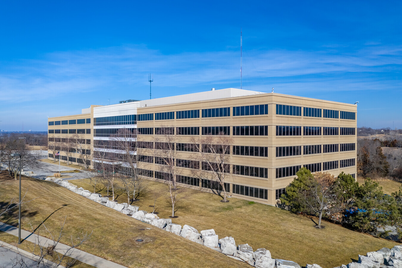
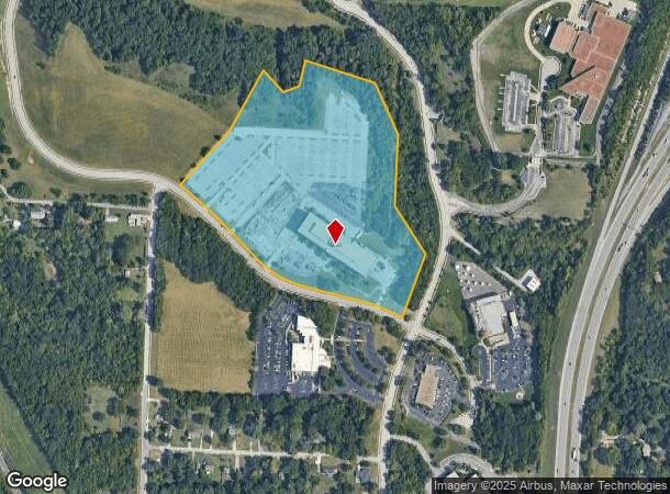
6501 Beacon Dr
Kansas City, MO-KS
Winchester Office Center West Phase Ii
46-140-09-07-00-0-00-000
WINCHESTER OFFICE CENTER WEST PHASE II LOT 1
Officebuilding
Jackson
X
Missouri
29095C0269G
1
2023
26.32 AC
2024
Kansas City MO
012501
Kansas City
112,500 SF
DEMOGRAPHICS near 6501 Beacon Dr
1 Mile
3 Mile
5 Mile
2024 Total Population
1,652
50,076
186,982
2029 Population
1,669
50,377
187,898
Pop Growth 2024-2029
+ 1.03%
+ 0.60%
+ 0.49%
Average Age
40
39
39
2024 Total Households
730
21,257
79,236
HH Growth 2024-2029
+ 0.82%
+ 0.50%
+ 0.37%
Median Household Inc
$55,416
$49,501
$53,807
Avg Household Size
2.20
2.30
2.20
2024 Avg HH Vehicles
2.00
2.00
2.00
Median Home Value
$144,026
$126,750
$158,540
Median Year Built
1962
1961
1958
Nearby Places
- Restaurants
- Banks
- Shops
- Fitness
- Groceries
PUBLIC TRANSPORTATION
COMMUTER RAIL
Kansas City (Lincoln Service Missouri River Runner - Amtrak, Missouri River Runner - Amtrak, Southwest Chief - Amtrak)
DRIVE
WALK
Distance
Kansas City (Lincoln Service Missouri River Runner - Amtrak, Missouri River Runner - Amtrak, Southwest Chief - Amtrak)
19 min
9.7 mi
AIRPORT
Kansas City International
DRIVE
WALK
Distance
Kansas City International
44 min
29.9 mi
Freight Ports
Tulsa Port Of Catoosa
DRIVE
WALK
Distance
Tulsa Port Of Catoosa
267 min
236.2 mi
Nearby Properties
Address
Land Use
TOTAL SIZE
Lot Size
Zoning
Address
Land Use
TOTAL SIZE
Lot Size
Zoning
153,946 SF
5.90 AC
Address
Land Use
TOTAL SIZE
Lot Size
Zoning
784,265 SF
23.72 AC
Address
Land Use
TOTAL SIZE
Lot Size
Zoning
62,211 SF
39.88 AC
Address
Land Use
TOTAL SIZE
Lot Size
Zoning
137,428 SF
27.76 AC
Address
Land Use
TOTAL SIZE
Lot Size
Zoning
608,974 SF
40.53 AC
Address
Land Use
TOTAL SIZE
Lot Size
Zoning
389,178 SF
33.30 AC
Address
Land Use
TOTAL SIZE
Lot Size
Zoning
148,196 SF
1.79 AC
Address
Land Use
TOTAL SIZE
Lot Size
Zoning
34,832 SF
8.29 AC
Address
Land Use
TOTAL SIZE
Lot Size
Zoning
291,768 SF
39.93 AC
Address
Land Use
TOTAL SIZE
Lot Size
Zoning
43,433 SF
21.81 AC
Address
Land Use
TOTAL SIZE
Lot Size
Zoning
Address
Land Use
TOTAL SIZE
Lot Size
Zoning
27,610 SF
7.50 AC
Address
Land Use
TOTAL SIZE
Lot Size
Zoning
82,607 SF
9.90 AC
Address
Land Use
TOTAL SIZE
Lot Size
Zoning
106,160 SF
25.09 AC
Address
Land Use
TOTAL SIZE
Lot Size
Zoning
68,309 SF
4.92 AC
Address
Land Use
TOTAL SIZE
Lot Size
Zoning
55,147 SF
13.26 AC
Address
Land Use
TOTAL SIZE
Lot Size
Zoning
127,732 SF
152 AC
Address
Land Use
TOTAL SIZE
Lot Size
Zoning
77,689 SF
14.10 AC
Address
Land Use
TOTAL SIZE
Lot Size
Zoning
175,502 SF
0.27 AC
Address
Land Use
TOTAL SIZE
Lot Size
Zoning
286,962 SF
234.92 AC
Address
Land Use
TOTAL SIZE
Lot Size
Zoning
145,569 SF
16.90 AC
Address
Land Use
TOTAL SIZE
Lot Size
Zoning
107,289 SF
3.91 AC
C2R5
Address
Land Use
TOTAL SIZE
Lot Size
Zoning
65,969 SF
10.35 AC
Address
Land Use
TOTAL SIZE
Lot Size
Zoning
110,663 SF
19.86 AC
Address
Land Use
TOTAL SIZE
Lot Size
Zoning
103,076 SF
21.88 AC
Address
Land Use
TOTAL SIZE
Lot Size
Zoning
9.57 AC
Address
Land Use
TOTAL SIZE
Lot Size
Zoning
Address
Land Use
TOTAL SIZE
Lot Size
Zoning
82,432 SF
5.24 AC
Address
Land Use
TOTAL SIZE
Lot Size
Zoning
180,877 SF
70.70 AC
The World's #1 Commercial Real Estate Marketplace
Connect with us
© 2025 CoStar Group
The information above has been obtained from sources believed reliable. While we do not doubt its accuracy we have not verified it and make no guarantee, warranty or representation about it. It is your responsibility to independently confirm its accuracy and completeness. Any projections, opinions, assumptions, or estimates used are for example only and do not represent the current or future performance of the property. The value of this transaction to you depends on tax and other factors which should be evaluated by your tax, financial, and legal advisors. You and your advisors should conduct a careful, independent investigation of the property to determine to your satisfaction the suitability of the property for your needs.