Property Record
653 Bluefield Rd, Mooresville, NC 28117
NEARBY LISTINGS FOR SALE OR LEASE
Property Detail
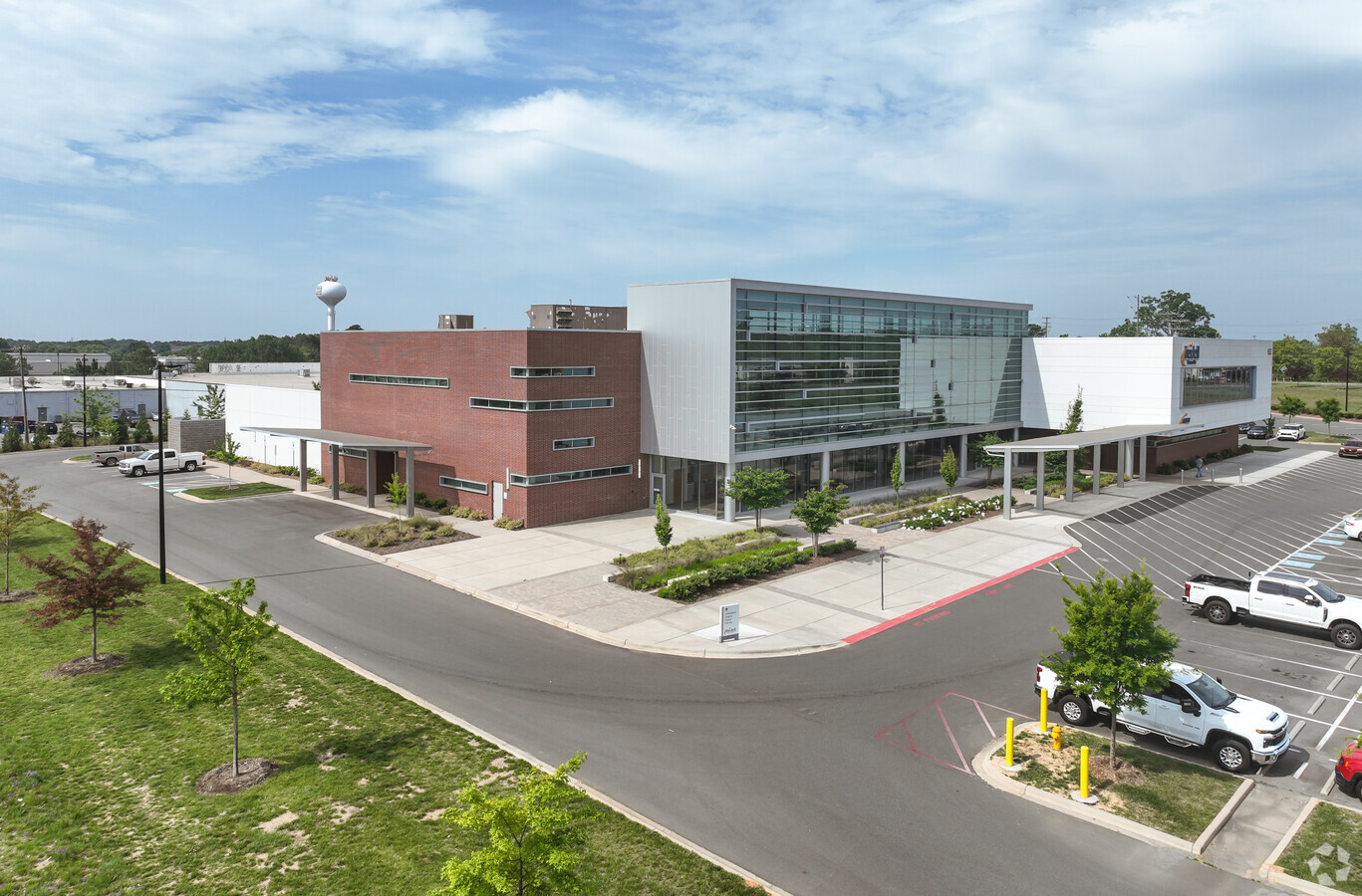
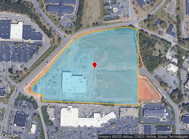
653 Bluefield Rd
Charlotte-Concord-Gastonia, NC-SC
CRIPPLE CREEK SR1467 ANNEX25-175 DOT2897/666
4647-57-3428.000
Iredell
Medicalbuilding
North Carolina
2024
15.66 AC
2024
Iredell County
061203
Charlotte
71,652 SF
DEMOGRAPHICS near 653 Bluefield Rd
1 Mile
3 Mile
5 Mile
2024 Total Population
4,712
35,551
82,308
2029 Population
5,391
40,269
93,300
Pop Growth 2024-2029
+ 14.41%
+ 13.27%
+ 13.35%
Average Age
40
40
40
2024 Total Households
2,037
14,643
32,143
HH Growth 2024-2029
+ 14.19%
+ 13.19%
+ 13.30%
Median Household Inc
$80,798
$82,369
$88,794
Avg Household Size
2.20
2.40
2.50
2024 Avg HH Vehicles
2.00
2.00
2.00
Median Home Value
$343,229
$319,192
$336,898
Median Year Built
2009
2002
2001
Nearby Places
- Restaurants
- Banks
- Shops
- Fitness
- Groceries
PUBLIC TRANSPORTATION
AIRPORT
Concord-Padgett Regional
DRIVE
WALK
Distance
Concord-Padgett Regional
34 min
25.4 mi
Charlotte/Douglas International
DRIVE
WALK
Distance
Charlotte/Douglas International
45 min
33.4 mi
Freight Ports
Port of Wilmington
DRIVE
WALK
Distance
Port of Wilmington
278 min
224.3 mi
SALE & LEASE HISTORY
LISTING DATE
SALE/LEASE

Feb 02, 2023
For Lease
Nearby Properties
Address
Land Use
TOTAL SIZE
Lot Size
Zoning
Address
Land Use
TOTAL SIZE
Lot Size
Zoning
55,473 SF
28.69 AC
CM
Address
Land Use
TOTAL SIZE
Lot Size
Zoning
45,582 SF
11.48 AC
CM
Address
Land Use
TOTAL SIZE
Lot Size
Zoning
79,967 SF
19.17 AC
CM
Address
Land Use
TOTAL SIZE
Lot Size
Zoning
8,620 SF
31.12 AC
TN
Address
Land Use
TOTAL SIZE
Lot Size
Zoning
26,946 SF
19.86 AC
TN
Address
Land Use
TOTAL SIZE
Lot Size
Zoning
4,516 SF
24.47 AC
CM
Address
Land Use
TOTAL SIZE
Lot Size
Zoning
27,545 SF
20.02 AC
TN
Address
Land Use
TOTAL SIZE
Lot Size
Zoning
60,233 SF
7.82 AC
CM
Address
Land Use
TOTAL SIZE
Lot Size
Zoning
27,657 SF
36.94 AC
TN
Address
Land Use
TOTAL SIZE
Lot Size
Zoning
8,491 SF
22.23 AC
CM
Address
Land Use
TOTAL SIZE
Lot Size
Zoning
67,175 SF
8.66 AC
CM
Address
Land Use
TOTAL SIZE
Lot Size
Zoning
28,284 SF
22.42 AC
TN
Address
Land Use
TOTAL SIZE
Lot Size
Zoning
8,842 SF
22.50 AC
CC
Address
Land Use
TOTAL SIZE
Lot Size
Zoning
8,328 SF
38.14 AC
IN
Address
Land Use
TOTAL SIZE
Lot Size
Zoning
29,316 SF
15.52 AC
TN
Address
Land Use
TOTAL SIZE
Lot Size
Zoning
71,652 SF
15.66 AC
CC
Address
Land Use
TOTAL SIZE
Lot Size
Zoning
7,632 SF
26 AC
TN
Address
Land Use
TOTAL SIZE
Lot Size
Zoning
6,375 SF
25.90 AC
RG
Address
Land Use
TOTAL SIZE
Lot Size
Zoning
30,038 SF
22.55 AC
CC
Address
Land Use
TOTAL SIZE
Lot Size
Zoning
129,131 SF
73.02 AC
RLS
Address
Land Use
TOTAL SIZE
Lot Size
Zoning
10,424 SF
15.90 AC
TN
Address
Land Use
TOTAL SIZE
Lot Size
Zoning
209,000 SF
50.72 AC
RA
Address
Land Use
TOTAL SIZE
Lot Size
Zoning
192,854 SF
62.67 AC
RA
Address
Land Use
TOTAL SIZE
Lot Size
Zoning
13,740 SF
15 AC
CC
Address
Land Use
TOTAL SIZE
Lot Size
Zoning
27,766 SF
15.31 AC
RG
Address
Land Use
TOTAL SIZE
Lot Size
Zoning
9,200 SF
9.74 AC
CC
Address
Land Use
TOTAL SIZE
Lot Size
Zoning
159,468 SF
16.61 AC
CC
Address
Land Use
TOTAL SIZE
Lot Size
Zoning
57,142 SF
6 AC
CC
Address
Land Use
TOTAL SIZE
Lot Size
Zoning
87,626 SF
22.38 AC
R3
The World's #1 Commercial Real Estate Marketplace
Connect with us
© 2025 CoStar Group
The information above has been obtained from sources believed reliable. While we do not doubt its accuracy we have not verified it and make no guarantee, warranty or representation about it. It is your responsibility to independently confirm its accuracy and completeness. Any projections, opinions, assumptions, or estimates used are for example only and do not represent the current or future performance of the property. The value of this transaction to you depends on tax and other factors which should be evaluated by your tax, financial, and legal advisors. You and your advisors should conduct a careful, independent investigation of the property to determine to your satisfaction the suitability of the property for your needs.