Property Record
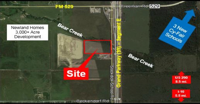
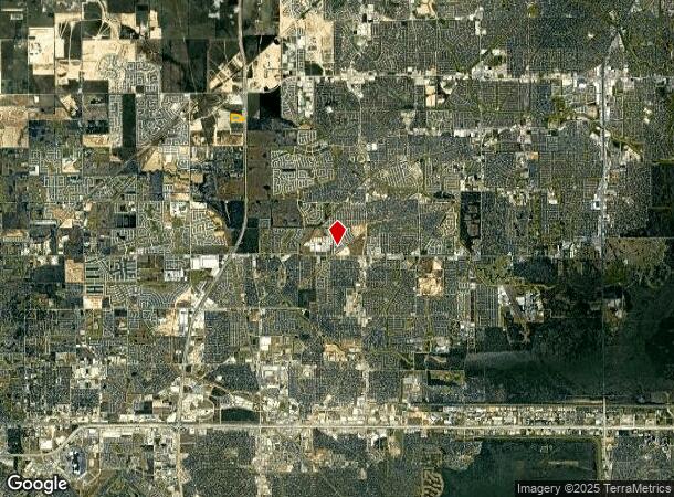
6545 Stockdick School Rd, Katy, TX 77449
NEARBY LISTINGS FOR SALE OR LEASE
Property Detail
6545 Stockdick School Rd
0431120000006
Abst 446 H&Tcrr Sec 31
Outdoorrecreationbeachmountaindesert
TR 1C ABST 446 H&TCRR SEC 31 BLK 2
AE
Harris
48201C0585M
Texas
2023
11.47 AC
2023
Katy/Grand Parkway West
542202
Houston
22,475 SF
Houston-The Woodlands-Sugar Land, TX
DEMOGRAPHICS near 6545 Stockdick School Rd
1 Mile
3 Mile
5 Mile
2024 Total Population
1,527
70,955
230,922
2029 Population
1,646
74,420
239,339
Pop Growth 2024-2029
+ 7.79%
+ 4.88%
+ 3.64%
Average Age
33
33
34
2024 Total Households
449
20,444
68,255
HH Growth 2024-2029
+ 7.80%
+ 4.89%
+ 3.59%
Median Household Inc
$73,377
$87,854
$92,452
Avg Household Size
3.40
3.40
3.30
2024 Avg HH Vehicles
2.00
2.00
2.00
Median Home Value
$221,921
$236,543
$239,082
Median Year Built
2010
2010
2009
Nearby Places
- Restaurants
- Banks
- Shops
- Fitness
- Groceries
PUBLIC TRANSPORTATION
AIRPORT
George Bush Intcntl/Houston
DRIVE
WALK
Distance
George Bush Intcntl/Houston
46 min
34.0 mi
William P Hobby
DRIVE
WALK
Distance
William P Hobby
59 min
38.9 mi
Freight Ports
Port of Houston
DRIVE
WALK
Distance
Port of Houston
52 min
35.7 mi
SALE & LEASE HISTORY
LISTING DATE
SALE/LEASE

Sep 24, 2016
For Sale
Mar 19, 2018
For Lease
Nearby Properties
Address
Land Use
TOTAL SIZE
Lot Size
Zoning
Address
Land Use
TOTAL SIZE
Lot Size
Zoning
826,250 SF
54.15 AC
Address
Land Use
TOTAL SIZE
Lot Size
Zoning
395,495 SF
13.83 AC
Address
Land Use
TOTAL SIZE
Lot Size
Zoning
439,347 SF
13.50 AC
Address
Land Use
TOTAL SIZE
Lot Size
Zoning
891,129 SF
44.38 AC
Address
Land Use
TOTAL SIZE
Lot Size
Zoning
341,844 SF
16.71 AC
Address
Land Use
TOTAL SIZE
Lot Size
Zoning
343,605 SF
11.90 AC
Address
Land Use
TOTAL SIZE
Lot Size
Zoning
305,624 SF
13.12 AC
Address
Land Use
TOTAL SIZE
Lot Size
Zoning
347,834 SF
15.25 AC
Address
Land Use
TOTAL SIZE
Lot Size
Zoning
284,321 SF
10.54 AC
Address
Land Use
TOTAL SIZE
Lot Size
Zoning
335,899 SF
12.62 AC
Address
Land Use
TOTAL SIZE
Lot Size
Zoning
331,263 SF
11.36 AC
Address
Land Use
TOTAL SIZE
Lot Size
Zoning
693,781 SF
6.86 AC
Address
Land Use
TOTAL SIZE
Lot Size
Zoning
334,971 SF
18.43 AC
Address
Land Use
TOTAL SIZE
Lot Size
Zoning
272,033 SF
12.74 AC
Address
Land Use
TOTAL SIZE
Lot Size
Zoning
439,808 SF
23.75 AC
Address
Land Use
TOTAL SIZE
Lot Size
Zoning
235,154 SF
13 AC
Address
Land Use
TOTAL SIZE
Lot Size
Zoning
347,192 SF
16.10 AC
Address
Land Use
TOTAL SIZE
Lot Size
Zoning
305,624 SF
Address
Land Use
TOTAL SIZE
Lot Size
Zoning
266,532 SF
6.45 AC
Address
Land Use
TOTAL SIZE
Lot Size
Zoning
262,174 SF
11.64 AC
Address
Land Use
TOTAL SIZE
Lot Size
Zoning
375,152 SF
19.57 AC
Address
Land Use
TOTAL SIZE
Lot Size
Zoning
206,020 SF
8.98 AC
Address
Land Use
TOTAL SIZE
Lot Size
Zoning
131,544 SF
19.04 AC
Address
Land Use
TOTAL SIZE
Lot Size
Zoning
211,757 SF
9.02 AC
Address
Land Use
TOTAL SIZE
Lot Size
Zoning
420,370 SF
17.05 AC
Address
Land Use
TOTAL SIZE
Lot Size
Zoning
339,835 SF
12.09 AC
Address
Land Use
TOTAL SIZE
Lot Size
Zoning
292,645 SF
12.71 AC
Address
Land Use
TOTAL SIZE
Lot Size
Zoning
266,532 SF
21.76 AC
Address
Land Use
TOTAL SIZE
Lot Size
Zoning
270,000 SF
14.25 AC
Address
Land Use
TOTAL SIZE
Lot Size
Zoning
838,700 SF
36.68 AC
The World's #1 Commercial Real Estate Marketplace
Connect with us
© 2025 CoStar Group
The information above has been obtained from sources believed reliable. While we do not doubt its accuracy we have not verified it and make no guarantee, warranty or representation about it. It is your responsibility to independently confirm its accuracy and completeness. Any projections, opinions, assumptions, or estimates used are for example only and do not represent the current or future performance of the property. The value of this transaction to you depends on tax and other factors which should be evaluated by your tax, financial, and legal advisors. You and your advisors should conduct a careful, independent investigation of the property to determine to your satisfaction the suitability of the property for your needs.