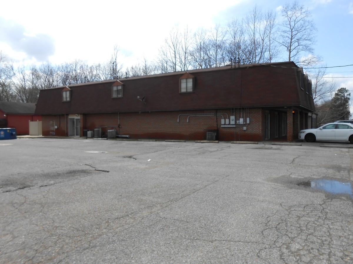
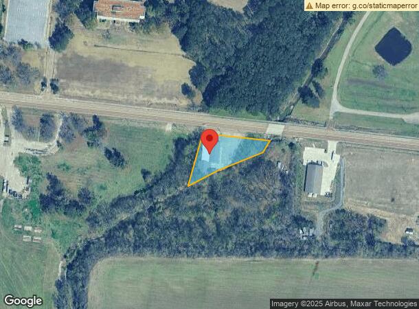
Property Record
6543 Navy Rd, Millington, TN 38053
NEARBY LISTINGS FOR SALE OR LEASE
-
-
View all Millington listings for sale on LoopNet.com
Property Detail
6543 Navy Rd
Memphis, TN-MS-AR
Casper Creek
D0-116D-00-002C
SS NAVY ROAD
Animalhospitalvet
Shelby
AE
Tennessee
47157C0180G
1&2
2023
1.38 AC
2024
North
020210
Memphis
11,267 SF
DEMOGRAPHICS near 6543 Navy Rd
1 Mile
3 Mile
5 Mile
2024 Total Population
2,537
5,062
19,861
2029 Population
2,500
4,972
19,631
Pop Growth 2024-2029
(1.46%)
(1.78%)
(1.16%)
Average Age
37
38
40
2024 Total Households
918
1,900
7,603
HH Growth 2024-2029
(1.53%)
(1.84%)
(1.28%)
Median Household Inc
$51,786
$55,533
$61,295
Avg Household Size
2.70
2.60
2.50
2024 Avg HH Vehicles
2.00
2.00
2.00
Median Home Value
$70,348
$167,672
$220,296
Median Year Built
1971
1972
1980
Nearby Places
- Restaurants
- Banks
- Shops
- Fitness
- Groceries
PUBLIC TRANSPORTATION
AIRPORT
Memphis International
DRIVE
WALK
Distance
Memphis International
41 min
25.5 mi
Freight Ports
Port of Shreveport
DRIVE
WALK
Distance
Port of Shreveport
424 min
387.8 mi
SALE & LEASE HISTORY
LISTING DATE
SALE/LEASE

Mar 05, 2018
For Sale
Nearby Properties
Address
Land Use
TOTAL SIZE
Lot Size
Zoning
Address
Land Use
TOTAL SIZE
Lot Size
Zoning
619.59 AC
M-2
Address
Land Use
TOTAL SIZE
Lot Size
Zoning
107,077 SF
10.98 AC
P-C
Address
Land Use
TOTAL SIZE
Lot Size
Zoning
62,477 SF
1.60 AC
B-2
Address
Land Use
TOTAL SIZE
Lot Size
Zoning
38.70 AC
M-1
Address
Land Use
TOTAL SIZE
Lot Size
Zoning
105.50 AC
M-1
Address
Land Use
TOTAL SIZE
Lot Size
Zoning
26,350 SF
4.08 AC
P-C
Address
Land Use
TOTAL SIZE
Lot Size
Zoning
184.12 AC
M-2
Address
Land Use
TOTAL SIZE
Lot Size
Zoning
347.69 AC
M-2
Address
Land Use
TOTAL SIZE
Lot Size
Zoning
108,870 SF
12.63 AC
R-0
Address
Land Use
TOTAL SIZE
Lot Size
Zoning
112.50 AC
M-2
Address
Land Use
TOTAL SIZE
Lot Size
Zoning
18,228 SF
4.41 AC
M-2
Address
Land Use
TOTAL SIZE
Lot Size
Zoning
437.93 AC
A
Address
Land Use
TOTAL SIZE
Lot Size
Zoning
32,257 SF
1.75 AC
B-2
Address
Land Use
TOTAL SIZE
Lot Size
Zoning
10,793 SF
1.30 AC
B-2
Address
Land Use
TOTAL SIZE
Lot Size
Zoning
59,559 SF
4.94 AC
B-2
Address
Land Use
TOTAL SIZE
Lot Size
Zoning
6,060 SF
5 AC
R-1
Address
Land Use
TOTAL SIZE
Lot Size
Zoning
20 AC
M-1
Address
Land Use
TOTAL SIZE
Lot Size
Zoning
45.10 AC
B-2
Address
Land Use
TOTAL SIZE
Lot Size
Zoning
5,152 SF
1.50 AC
B-2
Address
Land Use
TOTAL SIZE
Lot Size
Zoning
9,409 SF
4.64 AC
M-2
Address
Land Use
TOTAL SIZE
Lot Size
Zoning
6,260 SF
0.59 AC
P-C
Address
Land Use
TOTAL SIZE
Lot Size
Zoning
693.62 AC
CA
Address
Land Use
TOTAL SIZE
Lot Size
Zoning
26,075 SF
15.76 AC
P-C
Address
Land Use
TOTAL SIZE
Lot Size
Zoning
5,815 SF
3.03 AC
B-2
Address
Land Use
TOTAL SIZE
Lot Size
Zoning
21.04 AC
M-2
Address
Land Use
TOTAL SIZE
Lot Size
Zoning
8,750 SF
1.57 AC
R-8
Address
Land Use
TOTAL SIZE
Lot Size
Zoning
5,496 SF
0.87 AC
CMU-3
Address
Land Use
TOTAL SIZE
Lot Size
Zoning
15,630 SF
2.41 AC
CMU-1
Address
Land Use
TOTAL SIZE
Lot Size
Zoning
13,350 SF
2.27 AC
CMU-1
Address
Land Use
TOTAL SIZE
Lot Size
Zoning
6,380 SF
3.08 AC
B-2
The World's #1 Commercial Real Estate Marketplace
Connect with us
© 2025 CoStar Group
The information above has been obtained from sources believed reliable. While we do not doubt its accuracy we have not verified it and make no guarantee, warranty or representation about it. It is your responsibility to independently confirm its accuracy and completeness. Any projections, opinions, assumptions, or estimates used are for example only and do not represent the current or future performance of the property. The value of this transaction to you depends on tax and other factors which should be evaluated by your tax, financial, and legal advisors. You and your advisors should conduct a careful, independent investigation of the property to determine to your satisfaction the suitability of the property for your needs.