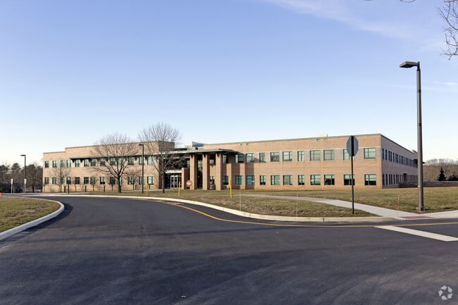
Property Record
660 Rosedale Rd, Princeton, NJ 08540
NEARBY LISTINGS FOR SALE OR LEASE
Property Detail
660 Rosedale Rd
07-07801-0000-00021
Mercer
Officebuilding
New Jersey
AE
21
34021C0127F
113.83 AC
2024
Trenton
2025
Northern New Jersey
003304
Trenton, NJ
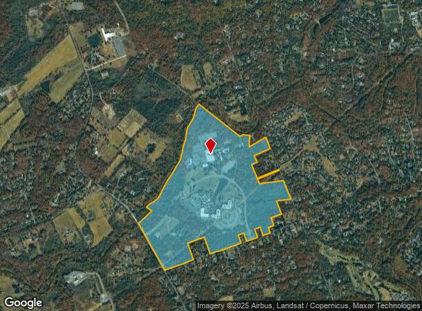
DEMOGRAPHICS near 660 Rosedale Rd
1 Mile
3 Mile
5 Mile
2024 Total Population
1,028
18,708
78,562
2029 Population
1,023
18,718
78,190
Pop Growth 2024-2029
(0.49%)
+ 0.05%
(0.47%)
Average Age
44
41
41
2024 Total Households
358
6,731
29,666
HH Growth 2024-2029
(0.84%)
+ 0.25%
(0.42%)
Median Household Inc
$249,580
$183,692
$144,202
Avg Household Size
2.80
2.60
2.50
2024 Avg HH Vehicles
2.00
2.00
2.00
Median Home Value
$997,916
$864,975
$651,216
Median Year Built
1987
1981
1983
Nearby Places
Map Layers
Map Styles
 Street
 Aerial
- Restaurants
- Banks
- Shops
- Fitness
- Groceries
PUBLIC TRANSPORTATION
COMMUTER RAIL
Princeton (Princeton Branch - NJ Transit Commuter Rail (NJ Transit))
DRIVE
WALK
Distance
Princeton (Princeton Branch - NJ Transit Commuter Rail (NJ Transit))
13 min
4.3 mi
Princeton Junction (Northeast Corridor Line - NJ Transit Commuter Rail (NJ Transit), Princeton Branch - NJ Transit Commuter Rail (NJ Transit))
DRIVE
WALK
Distance
Princeton Junction (Northeast Corridor Line - NJ Transit Commuter Rail (NJ Transit), Princeton Branch - NJ Transit Commuter Rail (NJ Transit))
20 min
7.3 mi
AIRPORT
Trenton Mercer
DRIVE
WALK
Distance
Trenton Mercer
22 min
12.0 mi
Freight Ports
Port of Philadelphia
DRIVE
WALK
Distance
Port of Philadelphia
59 min
39.5 mi
Nearby Properties
Address
Land Use
TOTAL SIZE
Lot Size
Zoning
Address
Land Use
TOTAL SIZE
Lot Size
Zoning
272.88 AC
RD-1
Address
Land Use
TOTAL SIZE
Lot Size
Zoning
8.97 AC
HMC
Address
Land Use
TOTAL SIZE
Lot Size
Zoning
52,000 SF
0.62 AC
CBCP
Address
Land Use
TOTAL SIZE
Lot Size
Zoning
36.45 AC
E4
Address
Land Use
TOTAL SIZE
Lot Size
Zoning
9.22 AC
E4
Address
Land Use
TOTAL SIZE
Lot Size
Zoning
1,577 SF
59.61 AC
E2
Address
Land Use
TOTAL SIZE
Lot Size
Zoning
4.44 AC
Address
Land Use
TOTAL SIZE
Lot Size
Zoning
72,000 SF
0.09 AC
CB
Address
Land Use
TOTAL SIZE
Lot Size
Zoning
30 AC
E4
Address
Land Use
TOTAL SIZE
Lot Size
Zoning
480 SF
5.23 AC
Address
Land Use
TOTAL SIZE
Lot Size
Zoning
149,709 SF
2.36 AC
Address
Land Use
TOTAL SIZE
Lot Size
Zoning
20.79 AC
E4
Address
Land Use
TOTAL SIZE
Lot Size
Zoning
4.39 AC
Address
Land Use
TOTAL SIZE
Lot Size
Zoning
27.04 AC
R1
Address
Land Use
TOTAL SIZE
Lot Size
Zoning
5.74 AC
E4
Address
Land Use
TOTAL SIZE
Lot Size
Zoning
2,938 SF
8.96 AC
E4
Address
Land Use
TOTAL SIZE
Lot Size
Zoning
29,088 SF
1.06 AC
Address
Land Use
TOTAL SIZE
Lot Size
Zoning
188,880 SF
0.69 AC
CBCP
Address
Land Use
TOTAL SIZE
Lot Size
Zoning
Address
Land Use
TOTAL SIZE
Lot Size
Zoning
71,001 SF
2.16 AC
Address
Land Use
TOTAL SIZE
Lot Size
Zoning
1.28 AC
CB
Address
Land Use
TOTAL SIZE
Lot Size
Zoning
85,345 SF
1.77 AC
Address
Land Use
TOTAL SIZE
Lot Size
Zoning
1.50 AC
E4MP
Address
Land Use
TOTAL SIZE
Lot Size
Zoning
80,506 SF
1.99 AC
Address
Land Use
TOTAL SIZE
Lot Size
Zoning
0.02 AC
CBCP
Address
Land Use
TOTAL SIZE
Lot Size
Zoning
65,435 SF
2.60 AC
Address
Land Use
TOTAL SIZE
Lot Size
Zoning
Address
Land Use
TOTAL SIZE
Lot Size
Zoning
62,821 SF
0.35 AC
CBCP
Address
Land Use
TOTAL SIZE
Lot Size
Zoning
58,337 SF
1.86 AC
The World's #1 Commercial Real Estate Marketplace
Connect with us
© 2026 CoStar Group
The information above has been obtained from sources believed reliable. While we do not doubt its accuracy we have not verified it and make no guarantee, warranty or representation about it. It is your responsibility to independently confirm its accuracy and completeness. Any projections, opinions, assumptions, or estimates used are for example only and do not represent the current or future performance of the property. The value of this transaction to you depends on tax and other factors which should be evaluated by your tax, financial, and legal advisors. You and your advisors should conduct a careful, independent investigation of the property to determine to your satisfaction the suitability of the property for your needs.