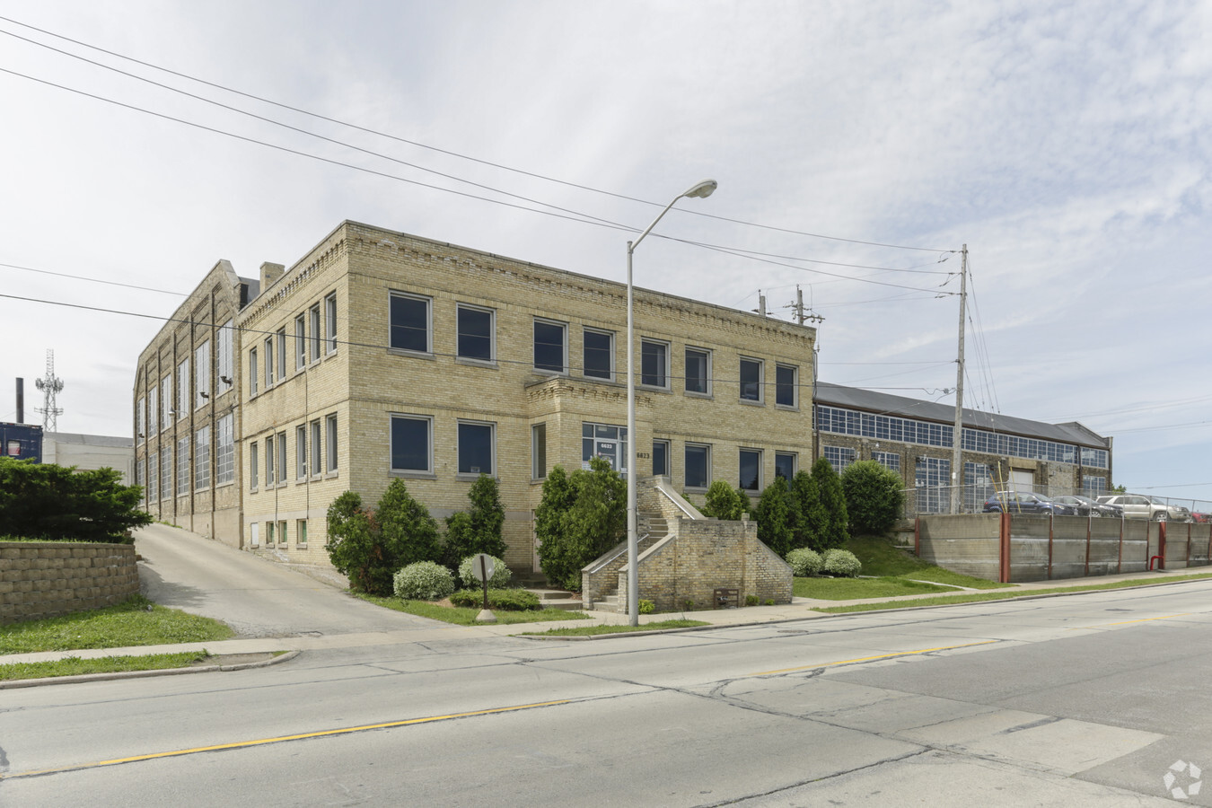
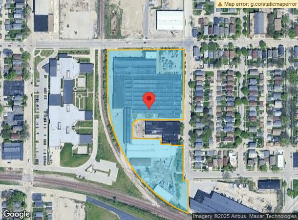
Property Record
1745 S 66Th St, Milwaukee, WI 53214

NEARBY LISTINGS FOR SALE OR LEASE
Property Detail
1745 S 66Th St
Milwaukee-Waukesha-West Allis, WI
Redivision Of Lot 4 Blk 3 Assessors Plat
454-0255-001
CERTIFIED SUR MAP #4912 DOC #6036691
Commercialnec
Milwaukee
X
Wisconsin
55079C0088E
6.89 AC
2023
West Allis
2023
Milwaukee/Madison
100400
DEMOGRAPHICS near 1745 S 66Th St
1 Mile
3 Mile
5 Mile
2024 Total Population
25,906
170,210
435,214
2029 Population
25,359
165,980
427,194
Pop Growth 2024-2029
(2.11%)
(2.49%)
(1.84%)
Average Age
39
38
37
2024 Total Households
11,509
71,949
180,419
HH Growth 2024-2029
(2.12%)
(2.49%)
(1.83%)
Median Household Inc
$57,946
$58,026
$55,815
Avg Household Size
2.10
2.30
2.30
2024 Avg HH Vehicles
2.00
2.00
1.00
Median Home Value
$162,816
$173,742
$193,444
Median Year Built
1948
1951
1952
Nearby Places
- Restaurants
- Banks
- Shops
- Fitness
- Groceries
PUBLIC TRANSPORTATION
COMMUTER RAIL
Milwaukee (Empire Builder - Amtrak)
DRIVE
WALK
Distance
Milwaukee (Empire Builder - Amtrak)
10 min
5.2 mi
General Mitchell Intl. Airport Amtrak Station (Hiawatha Service - Amtrak)
DRIVE
WALK
Distance
General Mitchell Intl. Airport Amtrak Station (Hiawatha Service - Amtrak)
21 min
8.9 mi
AIRPORT
General Mitchell International
DRIVE
WALK
Distance
General Mitchell International
21 min
9.1 mi
Freight Ports
Port Milwaukee
DRIVE
WALK
Distance
Port Milwaukee
13 min
5.1 mi
SALE & LEASE HISTORY
LISTING DATE
SALE/LEASE

Jul 24, 2020
For Lease
Jul 11, 2017
For Lease
Nearby Properties
Address
Land Use
TOTAL SIZE
Lot Size
Zoning
Address
Land Use
TOTAL SIZE
Lot Size
Zoning
52.61 AC
INSTITUTIO
Address
Land Use
TOTAL SIZE
Lot Size
Zoning
20.55 AC
Address
Land Use
TOTAL SIZE
Lot Size
Zoning
36.11 AC
Address
Land Use
TOTAL SIZE
Lot Size
Zoning
122.52 AC
TL
Address
Land Use
TOTAL SIZE
Lot Size
Zoning
23.16 AC
Address
Land Use
TOTAL SIZE
Lot Size
Zoning
35.55 AC
INSTITUTIO
Address
Land Use
TOTAL SIZE
Lot Size
Zoning
13.48 AC
Address
Land Use
TOTAL SIZE
Lot Size
Zoning
5.12 AC
Address
Land Use
TOTAL SIZE
Lot Size
Zoning
68.35 AC
TL
Address
Land Use
TOTAL SIZE
Lot Size
Zoning
Address
Land Use
TOTAL SIZE
Lot Size
Zoning
9.33 AC
PUD
Address
Land Use
TOTAL SIZE
Lot Size
Zoning
47.96 AC
TL
Address
Land Use
TOTAL SIZE
Lot Size
Zoning
3.74 AC
PUD
Address
Land Use
TOTAL SIZE
Lot Size
Zoning
8,881 SF
7.52 AC
Address
Land Use
TOTAL SIZE
Lot Size
Zoning
8.78 AC
Address
Land Use
TOTAL SIZE
Lot Size
Zoning
0.36 AC
Address
Land Use
TOTAL SIZE
Lot Size
Zoning
20.60 AC
TL
Address
Land Use
TOTAL SIZE
Lot Size
Zoning
132,289 SF
5.34 AC
PD
Address
Land Use
TOTAL SIZE
Lot Size
Zoning
44.01 AC
INSTITUTIO
Address
Land Use
TOTAL SIZE
Lot Size
Zoning
20.49 AC
TL
Address
Land Use
TOTAL SIZE
Lot Size
Zoning
164,825 SF
7.93 AC
PD
Address
Land Use
TOTAL SIZE
Lot Size
Zoning
7.55 AC
SP-INS
Address
Land Use
TOTAL SIZE
Lot Size
Zoning
5.31 AC
Address
Land Use
TOTAL SIZE
Lot Size
Zoning
159,673 SF
6.78 AC
PD
Address
Land Use
TOTAL SIZE
Lot Size
Zoning
39.81 AC
Address
Land Use
TOTAL SIZE
Lot Size
Zoning
16.84 AC
Address
Land Use
TOTAL SIZE
Lot Size
Zoning
4.62 AC
IO2
Address
Land Use
TOTAL SIZE
Lot Size
Zoning
2.29 AC
INSTITUTIO
Address
Land Use
TOTAL SIZE
Lot Size
Zoning
13.39 AC
Address
Land Use
TOTAL SIZE
Lot Size
Zoning
113,300 SF
5.60 AC
IL1
The World's #1 Commercial Real Estate Marketplace
Connect with us
© 2025 CoStar Group
The information above has been obtained from sources believed reliable. While we do not doubt its accuracy we have not verified it and make no guarantee, warranty or representation about it. It is your responsibility to independently confirm its accuracy and completeness. Any projections, opinions, assumptions, or estimates used are for example only and do not represent the current or future performance of the property. The value of this transaction to you depends on tax and other factors which should be evaluated by your tax, financial, and legal advisors. You and your advisors should conduct a careful, independent investigation of the property to determine to your satisfaction the suitability of the property for your needs.