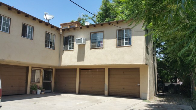
Property Record
672 W 9Th St, San Bernardino, CA 92410


NEARBY LISTINGS FOR SALE OR LEASE
Property Detail
672 W 9Th St
Riverside-San Bernardino-Ontario, CA
San Bernardino
0140-142-18
C1TY COM AT PT 49 FT 8 1NCHES W OF SE COR LOT 2 BLK 70 TH N 141.25 FT TH W 99 FT 4 1NCHES TH S 141.25 FT TH E 99 FT 4 1NCHES TO POB
Apartment
San Bernardino
X
California
06071C8681J
2
2024
0.32 AC
2025
Downtown San Bernardino
005601
Inland Empire (California)
7,221 SF
DEMOGRAPHICS near 672 W 9Th St
1 Mile
3 Mile
5 Mile
2024 Total Population
25,197
156,064
384,757
2029 Population
25,528
158,133
390,963
Pop Growth 2024-2029
+ 1.31%
+ 1.33%
+ 1.61%
Average Age
33
34
34
2024 Total Households
7,258
42,874
108,246
HH Growth 2024-2029
+ 1.60%
+ 1.42%
+ 1.70%
Median Household Inc
$40,685
$50,934
$59,060
Avg Household Size
3.30
3.50
3.40
2024 Avg HH Vehicles
2.00
2.00
2.00
Median Home Value
$275,559
$303,441
$342,350
Median Year Built
1962
1960
1969
Nearby Places
Map Layers
Map Styles
 Street
 Aerial
- Restaurants
- Banks
- Shops
- Fitness
- Groceries
PUBLIC TRANSPORTATION
COMMUTER RAIL
San Bernardino (Inland Empire-Orange County Line - Southern California Regional Rail Authority (Metrolink), San Bernardino Line - Southern California Regional Rail Authority (Metrolink))
DRIVE
WALK
Distance
San Bernardino (Inland Empire-Orange County Line - Southern California Regional Rail Authority (Metrolink), San Bernardino Line - Southern California Regional Rail Authority (Metrolink))
4 min
18 min
0.9 mi
Rialto (San Bernardino Line - Southern California Regional Rail Authority (Metrolink))
DRIVE
WALK
Distance
Rialto (San Bernardino Line - Southern California Regional Rail Authority (Metrolink))
13 min
5.4 mi
AIRPORT
Ontario International
DRIVE
WALK
Distance
Ontario International
27 min
23.3 mi
Freight Ports
Port of Long Beach
DRIVE
WALK
Distance
Port of Long Beach
1 min
56.4 mi
SALE & LEASE HISTORY
LISTING DATE
SALE/LEASE

May 23, 2017
For Sale
May 01, 2019
For Sale
Jun 26, 2017
For Sale
Jun 14, 2017
For Sale
Nearby Properties
Address
Land Use
TOTAL SIZE
Lot Size
Zoning
Address
Land Use
TOTAL SIZE
Lot Size
Zoning
2,134,798 SF
153.92 AC
Address
Land Use
TOTAL SIZE
Lot Size
Zoning
778,653 SF
19.31 AC
Address
Land Use
TOTAL SIZE
Lot Size
Zoning
457,253 SF
20.14 AC
Address
Land Use
TOTAL SIZE
Lot Size
Zoning
497,664 SF
56.39 AC
Address
Land Use
TOTAL SIZE
Lot Size
Zoning
1,032,072 SF
61.74 AC
Address
Land Use
TOTAL SIZE
Lot Size
Zoning
330,420 SF
15.31 AC
Address
Land Use
TOTAL SIZE
Lot Size
Zoning
1,081,199 SF
49.77 AC
Address
Land Use
TOTAL SIZE
Lot Size
Zoning
300,188 SF
11.98 AC
Address
Land Use
TOTAL SIZE
Lot Size
Zoning
379,299 SF
19.97 AC
Address
Land Use
TOTAL SIZE
Lot Size
Zoning
1,139,976 SF
49.56 AC
Address
Land Use
TOTAL SIZE
Lot Size
Zoning
758,180 SF
31.86 AC
Address
Land Use
TOTAL SIZE
Lot Size
Zoning
391,468 SF
16.73 AC
Address
Land Use
TOTAL SIZE
Lot Size
Zoning
1,205,400 SF
58.05 AC
Address
Land Use
TOTAL SIZE
Lot Size
Zoning
206,244 SF
15.22 AC
Address
Land Use
TOTAL SIZE
Lot Size
Zoning
913,716 SF
20 AC
Address
Land Use
TOTAL SIZE
Lot Size
Zoning
474,680 SF
17.95 AC
Address
Land Use
TOTAL SIZE
Lot Size
Zoning
404,725 SF
19.29 AC
Address
Land Use
TOTAL SIZE
Lot Size
Zoning
472,962 SF
23.28 AC
Address
Land Use
TOTAL SIZE
Lot Size
Zoning
178,926 SF
9.12 AC
IC
Address
Land Use
TOTAL SIZE
Lot Size
Zoning
549,796 SF
13.61 AC
Address
Land Use
TOTAL SIZE
Lot Size
Zoning
277,822 SF
13.65 AC
Address
Land Use
TOTAL SIZE
Lot Size
Zoning
335,000 SF
8.44 AC
Address
Land Use
TOTAL SIZE
Lot Size
Zoning
151,859 SF
7.23 AC
Address
Land Use
TOTAL SIZE
Lot Size
Zoning
415,405 SF
18.43 AC
IC
Address
Land Use
TOTAL SIZE
Lot Size
Zoning
592,710 SF
28.89 AC
Address
Land Use
TOTAL SIZE
Lot Size
Zoning
318,940 SF
14.26 AC
Address
Land Use
TOTAL SIZE
Lot Size
Zoning
154,639 SF
6.87 AC
Address
Land Use
TOTAL SIZE
Lot Size
Zoning
599,690 SF
17.08 AC
IC
Address
Land Use
TOTAL SIZE
Lot Size
Zoning
413,953 SF
19.58 AC
Address
Land Use
TOTAL SIZE
Lot Size
Zoning
159,956 SF
9.20 AC
The World's #1 Commercial Real Estate Marketplace
Connect with us
© 2026 CoStar Group
The information above has been obtained from sources believed reliable. While we do not doubt its accuracy we have not verified it and make no guarantee, warranty or representation about it. It is your responsibility to independently confirm its accuracy and completeness. Any projections, opinions, assumptions, or estimates used are for example only and do not represent the current or future performance of the property. The value of this transaction to you depends on tax and other factors which should be evaluated by your tax, financial, and legal advisors. You and your advisors should conduct a careful, independent investigation of the property to determine to your satisfaction the suitability of the property for your needs.