Property Record
6670 Clinton Hwy, Knoxville, TN 37912
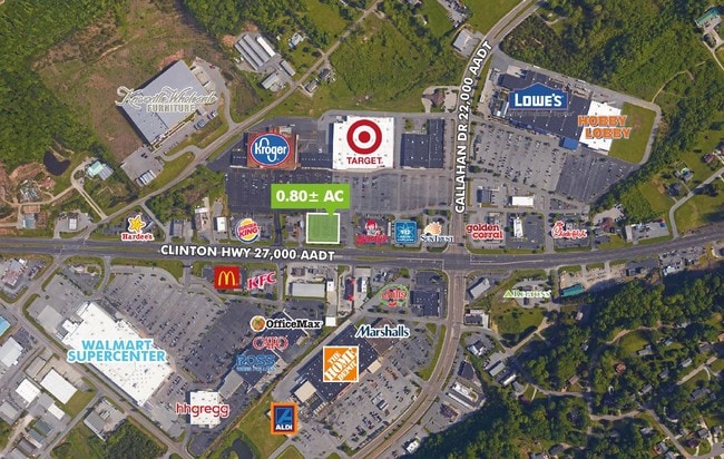

NEARBY LISTINGS FOR SALE OR LEASE
Property Detail
6670 Clinton Hwy
Knoxville, TN
Target Re Anx (2004) 0-412-95
067LB-005
SUBDIVISIONNAME TARGET RESUBDIVISION ANX (2004) 0-412-9 5 LOWLOT 1 HIGHLOT LOWBLOCK HIGHBLOCK DIMENSIONS 58. 75 X 180 X IRR
Wholesaleoutletdiscountstore
Knox
X
Tennessee
47093C0120F
1
2025
7.32 AC
2025
North/Broadway
004800
Knoxville
115,586 SF
DEMOGRAPHICS near 6670 Clinton Hwy
1 Mile
3 Mile
5 Mile
2024 Total Population
3,648
43,889
126,854
2029 Population
3,996
47,420
137,336
Pop Growth 2024-2029
+ 9.54%
+ 8.05%
+ 8.26%
Average Age
39
40
38
2024 Total Households
1,480
18,037
53,081
HH Growth 2024-2029
+ 9.59%
+ 8.13%
+ 8.38%
Median Household Inc
$74,062
$64,633
$57,021
Avg Household Size
2.40
2.40
2.30
2024 Avg HH Vehicles
2.00
2.00
2.00
Median Home Value
$211,625
$195,804
$209,810
Median Year Built
1994
1984
1983
Nearby Places
Map Layers
Map Styles
 Street
 Aerial
- Restaurants
- Banks
- Shops
- Fitness
- Groceries
PUBLIC TRANSPORTATION
AIRPORT
McGhee Tyson
DRIVE
WALK
Distance
McGhee Tyson
39 min
22.7 mi
Freight Ports
North Charleston Terminal
DRIVE
WALK
Distance
North Charleston Terminal
424 min
369.2 mi
SALE & LEASE HISTORY
LISTING DATE
SALE/LEASE

Nov 02, 2016
For Sale
Nearby Properties
Address
Land Use
TOTAL SIZE
Lot Size
Zoning
Address
Land Use
TOTAL SIZE
Lot Size
Zoning
4,922 SF
46.42 AC
Address
Land Use
TOTAL SIZE
Lot Size
Zoning
4,555 SF
23.09 AC
Address
Land Use
TOTAL SIZE
Lot Size
Zoning
3,697 SF
16.71 AC
Address
Land Use
TOTAL SIZE
Lot Size
Zoning
4,884 SF
22.38 AC
Address
Land Use
TOTAL SIZE
Lot Size
Zoning
3,046 SF
13.43 AC
Address
Land Use
TOTAL SIZE
Lot Size
Zoning
11,187 SF
9.85 AC
Address
Land Use
TOTAL SIZE
Lot Size
Zoning
122,198 SF
12.92 AC
Address
Land Use
TOTAL SIZE
Lot Size
Zoning
9,924 SF
10.20 AC
Address
Land Use
TOTAL SIZE
Lot Size
Zoning
50,857 SF
37.82 AC
Address
Land Use
TOTAL SIZE
Lot Size
Zoning
14,270 SF
46.96 AC
Address
Land Use
TOTAL SIZE
Lot Size
Zoning
172,462 SF
22.86 AC
Address
Land Use
TOTAL SIZE
Lot Size
Zoning
211,808 SF
17.33 AC
Address
Land Use
TOTAL SIZE
Lot Size
Zoning
96,514 SF
8.47 AC
Address
Land Use
TOTAL SIZE
Lot Size
Zoning
133,171 SF
11.96 AC
Address
Land Use
TOTAL SIZE
Lot Size
Zoning
49,190 SF
6.44 AC
Address
Land Use
TOTAL SIZE
Lot Size
Zoning
53,961 SF
2.32 AC
Address
Land Use
TOTAL SIZE
Lot Size
Zoning
16,000 SF
8.97 AC
Address
Land Use
TOTAL SIZE
Lot Size
Zoning
90,942 SF
4.05 AC
Address
Land Use
TOTAL SIZE
Lot Size
Zoning
23,306 SF
10.08 AC
Address
Land Use
TOTAL SIZE
Lot Size
Zoning
109,500 SF
10.03 AC
Address
Land Use
TOTAL SIZE
Lot Size
Zoning
48,957 SF
2.76 AC
Address
Land Use
TOTAL SIZE
Lot Size
Zoning
57,900 SF
9.97 AC
Address
Land Use
TOTAL SIZE
Lot Size
Zoning
2,562 SF
4.25 AC
Address
Land Use
TOTAL SIZE
Lot Size
Zoning
58,972 SF
4.94 AC
Address
Land Use
TOTAL SIZE
Lot Size
Zoning
48,130 SF
16.07 AC
Address
Land Use
TOTAL SIZE
Lot Size
Zoning
73,008 SF
2.45 AC
Address
Land Use
TOTAL SIZE
Lot Size
Zoning
17,112 SF
5 AC
Address
Land Use
TOTAL SIZE
Lot Size
Zoning
56,759 SF
5.22 AC
Address
Land Use
TOTAL SIZE
Lot Size
Zoning
15,400 SF
6.77 AC
Address
Land Use
TOTAL SIZE
Lot Size
Zoning
22,022 SF
3.13 AC
The World's #1 Commercial Real Estate Marketplace
Connect with us
© 2026 CoStar Group
The information above has been obtained from sources believed reliable. While we do not doubt its accuracy we have not verified it and make no guarantee, warranty or representation about it. It is your responsibility to independently confirm its accuracy and completeness. Any projections, opinions, assumptions, or estimates used are for example only and do not represent the current or future performance of the property. The value of this transaction to you depends on tax and other factors which should be evaluated by your tax, financial, and legal advisors. You and your advisors should conduct a careful, independent investigation of the property to determine to your satisfaction the suitability of the property for your needs.