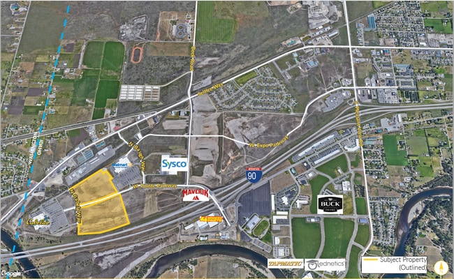
Property Record
6675 W Pointe Pkwy, Post Falls, ID 83854
NEARBY LISTINGS FOR SALE OR LEASE
-
-
Pleasant View and Lochsa @ Pleasant View and Lochsa
Post Falls, ID 83854
$1,399,000
3.61 AC Lots
Land
-
Pleasant View Road And Grange Avenue
Post Falls, ID 83854
$675,000 - $6,750,000
4.50 - 4.79 AC Lot
Land
-
-
View all Post Falls listings for sale on LoopNet.com
Property Detail
6675 W Pointe Pkwy
Coeur d'Alene, ID
Post Falls
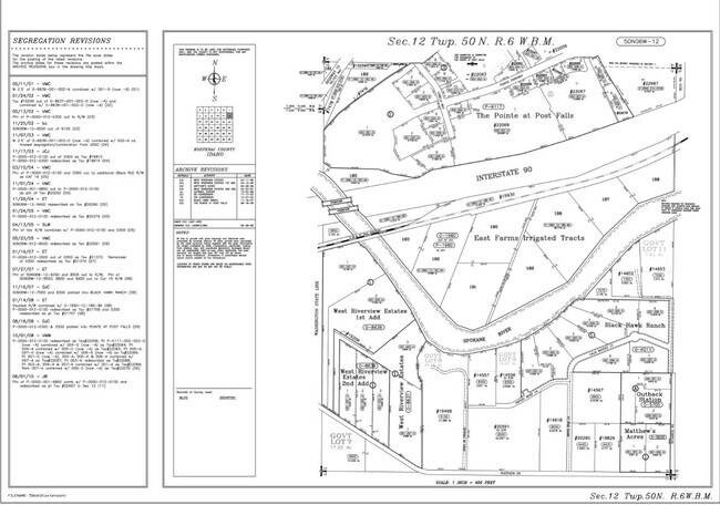
PK117003002A
THE POINTE AT POST FALLS, LT 10 BLOCK 3 1250N06W
Commercialacreage
Kootenai
X
Idaho
53063C0610D
10
2025
14.28 AC
2025
Post Falls
000401
Coeur D'Alene
DEMOGRAPHICS near 6675 W Pointe Pkwy
1 Mile
3 Mile
5 Mile
2024 Total Population
2,224
15,488
51,731
2029 Population
2,556
17,726
59,949
Pop Growth 2024-2029
+ 14.93%
+ 14.45%
+ 15.89%
Average Age
38
40
40
2024 Total Households
802
5,678
19,589
HH Growth 2024-2029
+ 15.96%
+ 14.92%
+ 16.17%
Median Household Inc
$59,807
$77,182
$83,471
Avg Household Size
2.70
2.70
2.60
2024 Avg HH Vehicles
2.00
2.00
2.00
Median Home Value
$462,499
$484,883
$506,248
Median Year Built
1997
1997
1997
Nearby Places
Map Layers
Map Styles
 Street
 Aerial
- Restaurants
- Banks
- Shops
- Fitness
- Groceries
PUBLIC TRANSPORTATION
AIRPORT
Spokane International
DRIVE
WALK
Distance
Spokane International
35 min
26.6 mi
Freight Ports
Port of Everett
DRIVE
WALK
Distance
Port of Everett
362 min
322.2 mi
SALE & LEASE HISTORY
LISTING DATE
SALE/LEASE

Apr 07, 2021
For Sale
Nearby Properties
Address
Land Use
TOTAL SIZE
Lot Size
Zoning
Address
Land Use
TOTAL SIZE
Lot Size
Zoning
602,024 SF
44.20 AC
I
Address
Land Use
TOTAL SIZE
Lot Size
Zoning
182,288 SF
45.50 AC
MZ
Address
Land Use
TOTAL SIZE
Lot Size
Zoning
53,118 SF
7.61 AC
Address
Land Use
TOTAL SIZE
Lot Size
Zoning
150,900 SF
7.24 AC
AG
Address
Land Use
TOTAL SIZE
Lot Size
Zoning
42,636 SF
24.81 AC
Address
Land Use
TOTAL SIZE
Lot Size
Zoning
235,906 SF
13.17 AC
Address
Land Use
TOTAL SIZE
Lot Size
Zoning
25,698 SF
11.33 AC
Address
Land Use
TOTAL SIZE
Lot Size
Zoning
145,377 SF
35.35 AC
Address
Land Use
TOTAL SIZE
Lot Size
Zoning
26,619 SF
15 AC
Address
Land Use
TOTAL SIZE
Lot Size
Zoning
165,984 SF
9.61 AC
Address
Land Use
TOTAL SIZE
Lot Size
Zoning
129,238 SF
24.58 AC
AG
Address
Land Use
TOTAL SIZE
Lot Size
Zoning
78,795 SF
39.53 AC
C2
Address
Land Use
TOTAL SIZE
Lot Size
Zoning
156,211 SF
17.09 AC
Address
Land Use
TOTAL SIZE
Lot Size
Zoning
199,920 SF
18.36 AC
COMDEV
Address
Land Use
TOTAL SIZE
Lot Size
Zoning
85,000 SF
1.22 AC
Address
Land Use
TOTAL SIZE
Lot Size
Zoning
64,648 SF
14.82 AC
AG
Address
Land Use
TOTAL SIZE
Lot Size
Zoning
60,246 SF
3.67 AC
Address
Land Use
TOTAL SIZE
Lot Size
Zoning
103,056 SF
8.18 AC
Address
Land Use
TOTAL SIZE
Lot Size
Zoning
115,992 SF
6.87 AC
Address
Land Use
TOTAL SIZE
Lot Size
Zoning
21,008 SF
2.53 AC
Address
Land Use
TOTAL SIZE
Lot Size
Zoning
31,986 SF
15.98 AC
Address
Land Use
TOTAL SIZE
Lot Size
Zoning
70,560 SF
14.69 AC
COMDEV
Address
Land Use
TOTAL SIZE
Lot Size
Zoning
108,441 SF
10.01 AC
COM
Address
Land Use
TOTAL SIZE
Lot Size
Zoning
66,603 SF
37.87 AC
R-5
Address
Land Use
TOTAL SIZE
Lot Size
Zoning
34,688 SF
5.50 AC
Address
Land Use
TOTAL SIZE
Lot Size
Zoning
41,462 SF
10 AC
Address
Land Use
TOTAL SIZE
Lot Size
Zoning
28,005 SF
2.98 AC
Address
Land Use
TOTAL SIZE
Lot Size
Zoning
28,579 SF
4.51 AC
Address
Land Use
TOTAL SIZE
Lot Size
Zoning
53,900 SF
4.37 AC
The World's #1 Commercial Real Estate Marketplace
Connect with us
© 2026 CoStar Group
The information above has been obtained from sources believed reliable. While we do not doubt its accuracy we have not verified it and make no guarantee, warranty or representation about it. It is your responsibility to independently confirm its accuracy and completeness. Any projections, opinions, assumptions, or estimates used are for example only and do not represent the current or future performance of the property. The value of this transaction to you depends on tax and other factors which should be evaluated by your tax, financial, and legal advisors. You and your advisors should conduct a careful, independent investigation of the property to determine to your satisfaction the suitability of the property for your needs.