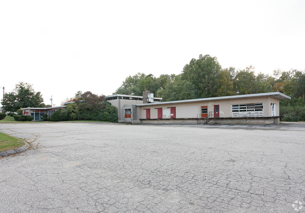
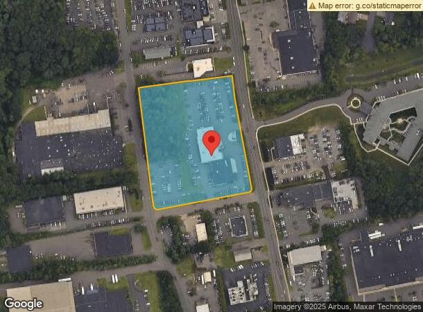
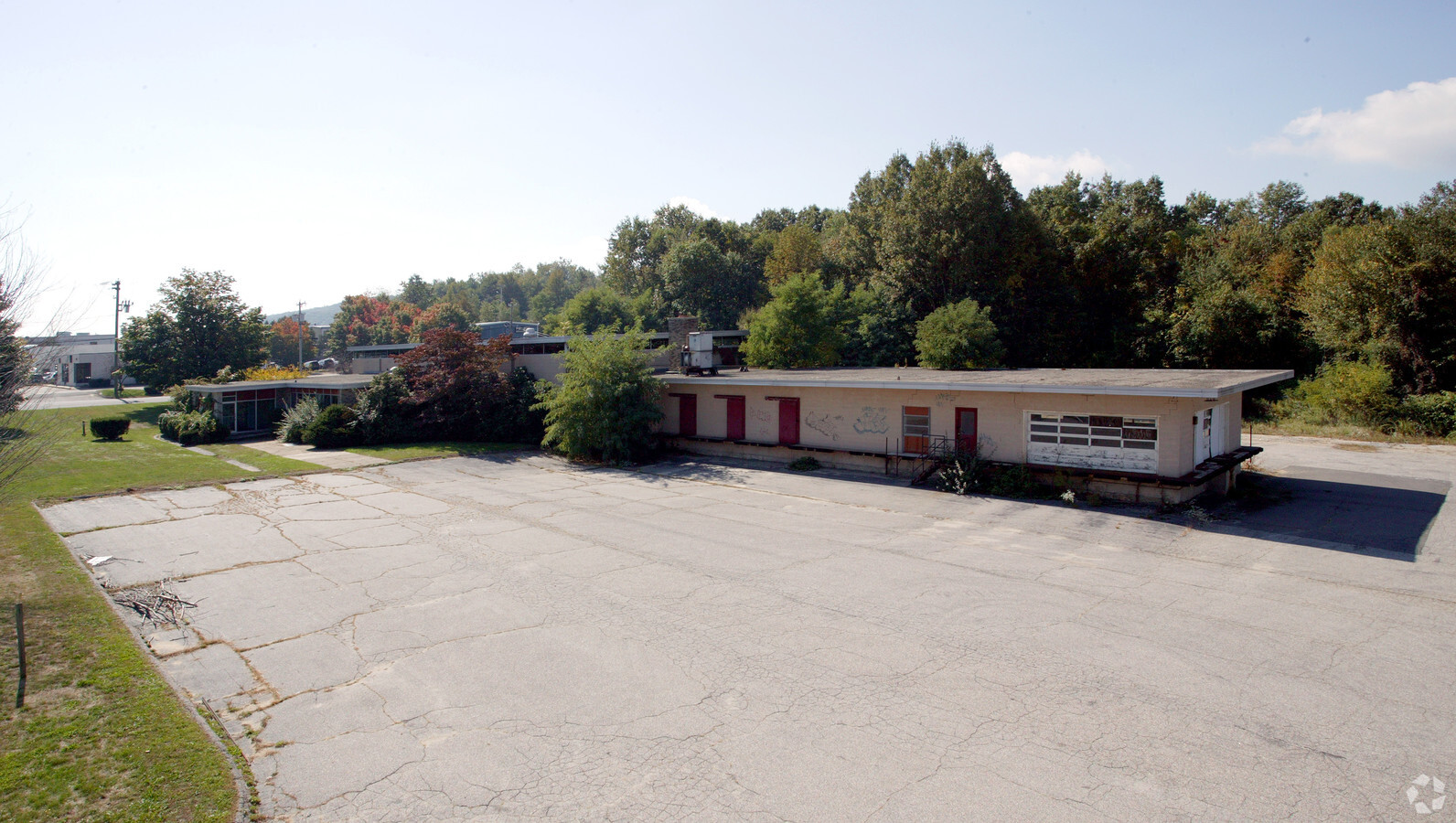
Property Record
674 Straits Tpke, Watertown, CT 06795
NEARBY LISTINGS FOR SALE OR LEASE
-
-
-
-
No Photo
-
-
-
-
View all Watertown listings for sale on LoopNet.com
Property Detail
674 Straits Tpke
Torrington, CT
Litchfield
WATE-000159-000045-000030
Connecticut
Vehiclerentalsvehiclesales
30
2024
4.78 AC
2024
New Milford/SW L'fld
360200
Hartford
26,210 SF
DEMOGRAPHICS near 674 Straits Tpke
1 Mile
3 Mile
5 Mile
2024 Total Population
4,906
49,583
124,390
2029 Population
4,929
49,434
123,986
Pop Growth 2024-2029
+ 0.47%
(0.30%)
(0.32%)
Average Age
44
40
39
2024 Total Households
1,854
18,949
47,976
HH Growth 2024-2029
+ 0.59%
(0.32%)
(0.32%)
Median Household Inc
$78,539
$69,254
$55,657
Avg Household Size
2.50
2.50
2.50
2024 Avg HH Vehicles
2.00
2.00
2.00
Median Home Value
$232,193
$225,446
$195,044
Median Year Built
1967
1961
1959
Nearby Places
- Restaurants
- Banks
- Shops
- Fitness
- Groceries
PUBLIC TRANSPORTATION
COMMUTER RAIL
Waterbury Station (New Haven Line - Metro-North Commuter Railroad Company (Metro-North))
DRIVE
WALK
Distance
Waterbury Station (New Haven Line - Metro-North Commuter Railroad Company (Metro-North))
9 min
4.5 mi
Naugatuck Station (New Haven Line - Metro-North Commuter Railroad Company (Metro-North))
DRIVE
WALK
Distance
Naugatuck Station (New Haven Line - Metro-North Commuter Railroad Company (Metro-North))
10 min
6.6 mi
AIRPORT
Tweed/New Haven
DRIVE
WALK
Distance
Tweed/New Haven
49 min
30.0 mi
Freight Ports
Port of New Haven
DRIVE
WALK
Distance
Port of New Haven
44 min
27.2 mi
Nearby Properties
Address
Land Use
TOTAL SIZE
Lot Size
Zoning
Address
Land Use
TOTAL SIZE
Lot Size
Zoning
196,057 SF
17 AC
RS
Address
Land Use
TOTAL SIZE
Lot Size
Zoning
16.10 AC
CO
Address
Land Use
TOTAL SIZE
Lot Size
Zoning
75 AC
R20
Address
Land Use
TOTAL SIZE
Lot Size
Zoning
156,279 SF
12.13 AC
RL
Address
Land Use
TOTAL SIZE
Lot Size
Zoning
182,949 SF
9.10 AC
RS
Address
Land Use
TOTAL SIZE
Lot Size
Zoning
155,861 SF
13.70 AC
R125
Address
Land Use
TOTAL SIZE
Lot Size
Zoning
201,817 SF
34.84 AC
R125
Address
Land Use
TOTAL SIZE
Lot Size
Zoning
140,700 SF
25.55 AC
R30
Address
Land Use
TOTAL SIZE
Lot Size
Zoning
129,672 SF
8 AC
IG
Address
Land Use
TOTAL SIZE
Lot Size
Zoning
36.10 AC
RS
Address
Land Use
TOTAL SIZE
Lot Size
Zoning
76,264 SF
15.03 AC
RS
Address
Land Use
TOTAL SIZE
Lot Size
Zoning
49,768 SF
4.35 AC
CO
Address
Land Use
TOTAL SIZE
Lot Size
Zoning
26.40 AC
RS-12
Address
Land Use
TOTAL SIZE
Lot Size
Zoning
30.46 AC
RM
Address
Land Use
TOTAL SIZE
Lot Size
Zoning
72,336 SF
15.39 AC
R30
Address
Land Use
TOTAL SIZE
Lot Size
Zoning
24.60 AC
RM
Address
Land Use
TOTAL SIZE
Lot Size
Zoning
54,820 SF
1.03 AC
CA
Address
Land Use
TOTAL SIZE
Lot Size
Zoning
209.81 AC
R125
Address
Land Use
TOTAL SIZE
Lot Size
Zoning
78,530 SF
20.98 AC
BSC
Address
Land Use
TOTAL SIZE
Lot Size
Zoning
326,357 SF
53.34 AC
IR200
Address
Land Use
TOTAL SIZE
Lot Size
Zoning
84,480 SF
11.06 AC
BSC
Address
Land Use
TOTAL SIZE
Lot Size
Zoning
180,169 SF
3.64 AC
RM
Address
Land Use
TOTAL SIZE
Lot Size
Zoning
53,668 SF
5.14 AC
CO
Address
Land Use
TOTAL SIZE
Lot Size
Zoning
12.45 AC
RM
Address
Land Use
TOTAL SIZE
Lot Size
Zoning
60,703 SF
6.60 AC
R125
Address
Land Use
TOTAL SIZE
Lot Size
Zoning
47.80 AC
RS
Address
Land Use
TOTAL SIZE
Lot Size
Zoning
178,860 SF
52.98 AC
IR200
Address
Land Use
TOTAL SIZE
Lot Size
Zoning
13.52 AC
RM
Address
Land Use
TOTAL SIZE
Lot Size
Zoning
12,764 SF
1.93 AC
CA
Address
Land Use
TOTAL SIZE
Lot Size
Zoning
216,200 SF
12.43 AC
IG
The World's #1 Commercial Real Estate Marketplace
Connect with us
© 2025 CoStar Group
The information above has been obtained from sources believed reliable. While we do not doubt its accuracy we have not verified it and make no guarantee, warranty or representation about it. It is your responsibility to independently confirm its accuracy and completeness. Any projections, opinions, assumptions, or estimates used are for example only and do not represent the current or future performance of the property. The value of this transaction to you depends on tax and other factors which should be evaluated by your tax, financial, and legal advisors. You and your advisors should conduct a careful, independent investigation of the property to determine to your satisfaction the suitability of the property for your needs.