Property Record
675 Us Highway 117 S, Burgaw, NC 28425
NEARBY LISTINGS FOR SALE OR LEASE
-
-
View all Burgaw listings for lease on LoopNet.com
Property Detail
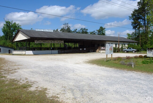
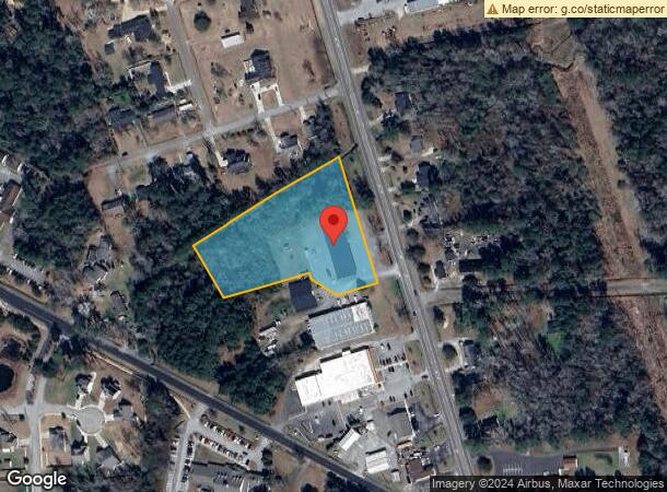
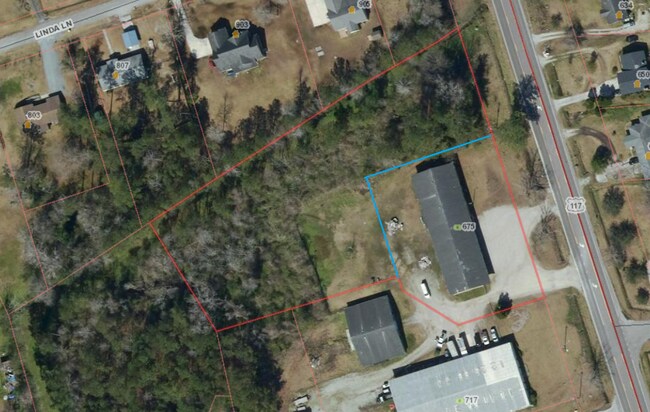
675 Us Highway 117 S
Wilmington, NC
Final Map Of Division Of The Bonnie Blue
3229-70-8883-0000
L1, PB 48/90, BONNIE BLUES BLUEBERRY SURVEY
Storebuilding
Pender
X
North Carolina
3720322900J
1
2024
2.95 AC
2024
West Pender County
920403
Wilmington
4,070 SF
DEMOGRAPHICS near 675 Us Highway 117 S
1 Mile
3 Mile
5 Mile
2024 Total Population
1,405
4,633
8,327
2029 Population
1,682
5,559
10,021
Pop Growth 2024-2029
+ 19.72%
+ 19.99%
+ 20.34%
Average Age
45
44
43
2024 Total Households
503
1,597
2,995
HH Growth 2024-2029
+ 19.68%
+ 20.29%
+ 20.67%
Median Household Inc
$62,213
$58,160
$56,775
Avg Household Size
2.40
2.40
2.40
2024 Avg HH Vehicles
2.00
2.00
2.00
Median Home Value
$214,102
$191,263
$184,886
Median Year Built
1990
1990
1992
Nearby Places
Map Layers
Map Styles
 Street
 Aerial
- Restaurants
- Banks
- Shops
- Fitness
- Groceries
PUBLIC TRANSPORTATION
AIRPORT
Wilmington International
DRIVE
WALK
Distance
Wilmington International
34 min
20.6 mi
Albert J Ellis
DRIVE
WALK
Distance
Albert J Ellis
49 min
32.4 mi
Freight Ports
Port of Wilmington
DRIVE
WALK
Distance
Port of Wilmington
42 min
29.5 mi
SALE & LEASE HISTORY
LISTING DATE
SALE/LEASE

May 22, 2023
For Lease
Nearby Properties
Address
Land Use
TOTAL SIZE
Lot Size
Zoning
Address
Land Use
TOTAL SIZE
Lot Size
Zoning
8,100 SF
60 AC
RA
Address
Land Use
TOTAL SIZE
Lot Size
Zoning
410,688 SF
17.71 AC
RA
Address
Land Use
TOTAL SIZE
Lot Size
Zoning
65,761 SF
3.75 AC
RA
Address
Land Use
TOTAL SIZE
Lot Size
Zoning
22,381 SF
6 AC
RA
Address
Land Use
TOTAL SIZE
Lot Size
Zoning
68,976 SF
8.36 AC
RA
Address
Land Use
TOTAL SIZE
Lot Size
Zoning
18,057 SF
13.28 AC
RA
Address
Land Use
TOTAL SIZE
Lot Size
Zoning
60,000 SF
9.68 AC
RA
Address
Land Use
TOTAL SIZE
Lot Size
Zoning
26,812 SF
16.72 AC
RA
Address
Land Use
TOTAL SIZE
Lot Size
Zoning
22,605 SF
4.13 AC
RA
Address
Land Use
TOTAL SIZE
Lot Size
Zoning
42,930 SF
2.91 AC
RA
Address
Land Use
TOTAL SIZE
Lot Size
Zoning
39,095 SF
2 AC
RA
Address
Land Use
TOTAL SIZE
Lot Size
Zoning
46,398 SF
3.88 AC
RA
Address
Land Use
TOTAL SIZE
Lot Size
Zoning
29,048 SF
1.75 AC
RA
Address
Land Use
TOTAL SIZE
Lot Size
Zoning
13,288 SF
6.86 AC
RA
Address
Land Use
TOTAL SIZE
Lot Size
Zoning
4,329 SF
4.50 AC
RA
Address
Land Use
TOTAL SIZE
Lot Size
Zoning
57,914 SF
7.08 AC
INCORP
Address
Land Use
TOTAL SIZE
Lot Size
Zoning
23,141 SF
1 AC
RA
Address
Land Use
TOTAL SIZE
Lot Size
Zoning
55,650 SF
7.39 AC
RA
Address
Land Use
TOTAL SIZE
Lot Size
Zoning
17,042 SF
1.15 AC
RA
Address
Land Use
TOTAL SIZE
Lot Size
Zoning
48,400 SF
6.63 AC
RA
Address
Land Use
TOTAL SIZE
Lot Size
Zoning
63,360 SF
6 AC
INCORP
Address
Land Use
TOTAL SIZE
Lot Size
Zoning
36,906 SF
9 AC
RA
Address
Land Use
TOTAL SIZE
Lot Size
Zoning
49,787 SF
11 AC
RA
Address
Land Use
TOTAL SIZE
Lot Size
Zoning
8,960 SF
4.12 AC
RA
Address
Land Use
TOTAL SIZE
Lot Size
Zoning
63,222 SF
5 AC
RA
Address
Land Use
TOTAL SIZE
Lot Size
Zoning
13,214 SF
0.62 AC
RA
Address
Land Use
TOTAL SIZE
Lot Size
Zoning
34,756 SF
6 AC
RA
Address
Land Use
TOTAL SIZE
Lot Size
Zoning
39,616 SF
6.50 AC
RA
Address
Land Use
TOTAL SIZE
Lot Size
Zoning
15,379 SF
3.70 AC
RA
Address
Land Use
TOTAL SIZE
Lot Size
Zoning
13,832 SF
0.50 AC
INCORP
The World's #1 Commercial Real Estate Marketplace
Connect with us
© 2026 CoStar Group
The information above has been obtained from sources believed reliable. While we do not doubt its accuracy we have not verified it and make no guarantee, warranty or representation about it. It is your responsibility to independently confirm its accuracy and completeness. Any projections, opinions, assumptions, or estimates used are for example only and do not represent the current or future performance of the property. The value of this transaction to you depends on tax and other factors which should be evaluated by your tax, financial, and legal advisors. You and your advisors should conduct a careful, independent investigation of the property to determine to your satisfaction the suitability of the property for your needs.