Property Record
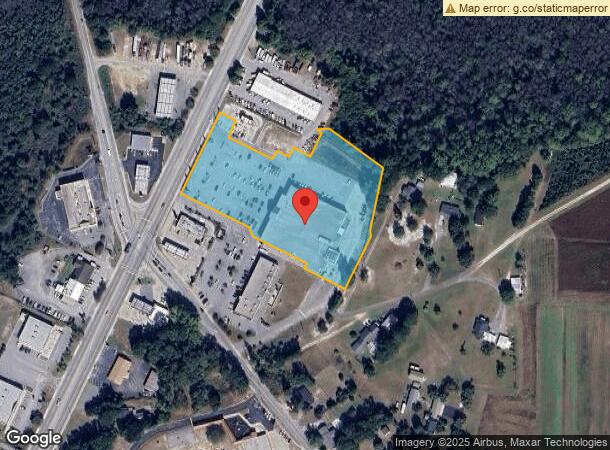
675 Main St, West Columbia, SC 29170
NEARBY LISTINGS FOR SALE OR LEASE
Property Detail
675 Main St
006798-06-008
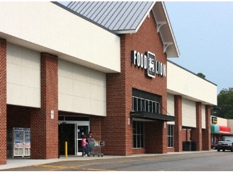
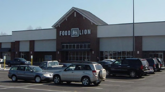
S. CONGAREE FOOD LION
Storebuilding
Lexington
AE
South Carolina
45063C0267J
4.53 AC
0
Cayce/West Columbia
2024
Columbia
020703
Columbia, SC
47,126 SF
DEMOGRAPHICS near 675 Main St
1 Mile
3 Mile
5 Mile
2024 Total Population
1,816
16,214
55,831
2029 Population
1,992
17,721
60,955
Pop Growth 2024-2029
+ 9.69%
+ 9.29%
+ 9.18%
Average Age
42
40
40
2024 Total Households
722
6,456
22,612
HH Growth 2024-2029
+ 9.70%
+ 9.42%
+ 9.32%
Median Household Inc
$45,268
$59,307
$60,411
Avg Household Size
2.40
2.50
2.40
2024 Avg HH Vehicles
2.00
2.00
2.00
Median Home Value
$160,198
$162,831
$149,862
Median Year Built
1977
1986
1987
Nearby Places
- Restaurants
- Banks
- Shops
- Fitness
- Groceries
PUBLIC TRANSPORTATION
AIRPORT
Columbia Metro
DRIVE
WALK
Distance
Columbia Metro
10 min
2.5 mi
Freight Ports
North Charleston Terminal
DRIVE
WALK
Distance
North Charleston Terminal
118 min
104.3 mi
Nearby Properties
Address
Land Use
TOTAL SIZE
Lot Size
Zoning
Address
Land Use
TOTAL SIZE
Lot Size
Zoning
461,888 SF
61.50 AC
ID
Address
Land Use
TOTAL SIZE
Lot Size
Zoning
3,614 SF
1,444.32 AC
ID
Address
Land Use
TOTAL SIZE
Lot Size
Zoning
180,000 SF
27.57 AC
ID
Address
Land Use
TOTAL SIZE
Lot Size
Zoning
9,800 SF
13.52 AC
ID
Address
Land Use
TOTAL SIZE
Lot Size
Zoning
5,502 SF
16.15 AC
ID
Address
Land Use
TOTAL SIZE
Lot Size
Zoning
41,860 SF
6.54 AC
ID
Address
Land Use
TOTAL SIZE
Lot Size
Zoning
318,309 SF
33.51 AC
ID
Address
Land Use
TOTAL SIZE
Lot Size
Zoning
200,000 SF
10.58 AC
ID
Address
Land Use
TOTAL SIZE
Lot Size
Zoning
279,568 SF
11.38 AC
ID
Address
Land Use
TOTAL SIZE
Lot Size
Zoning
430.11 AC
ID
Address
Land Use
TOTAL SIZE
Lot Size
Zoning
254,399 SF
49.79 AC
ID
Address
Land Use
TOTAL SIZE
Lot Size
Zoning
202,029 SF
21.13 AC
ID
Address
Land Use
TOTAL SIZE
Lot Size
Zoning
73,778 SF
4.95 AC
A
Address
Land Use
TOTAL SIZE
Lot Size
Zoning
17,442 SF
2.78 AC
Address
Land Use
TOTAL SIZE
Lot Size
Zoning
54,092 SF
5.90 AC
ID
Address
Land Use
TOTAL SIZE
Lot Size
Zoning
8,030 SF
1.66 AC
C1
Address
Land Use
TOTAL SIZE
Lot Size
Zoning
181,060 SF
10.61 AC
ID
Address
Land Use
TOTAL SIZE
Lot Size
Zoning
45,822 SF
9.88 AC
ID
Address
Land Use
TOTAL SIZE
Lot Size
Zoning
87.19 AC
ID
Address
Land Use
TOTAL SIZE
Lot Size
Zoning
111,130 SF
15.68 AC
ID
Address
Land Use
TOTAL SIZE
Lot Size
Zoning
96,736 SF
8.30 AC
Address
Land Use
TOTAL SIZE
Lot Size
Zoning
78.48 AC
ID
Address
Land Use
TOTAL SIZE
Lot Size
Zoning
31,000 SF
7.49 AC
C2
Address
Land Use
TOTAL SIZE
Lot Size
Zoning
42.62 AC
ID
Address
Land Use
TOTAL SIZE
Lot Size
Zoning
32,239 SF
2.66 AC
ID
Address
Land Use
TOTAL SIZE
Lot Size
Zoning
Address
Land Use
TOTAL SIZE
Lot Size
Zoning
40,550 SF
3.95 AC
ID
Address
Land Use
TOTAL SIZE
Lot Size
Zoning
3,000 SF
2.75 AC
ID
Address
Land Use
TOTAL SIZE
Lot Size
Zoning
9,882 SF
1.60 AC
RD
The World's #1 Commercial Real Estate Marketplace
Connect with us
© 2025 CoStar Group
The information above has been obtained from sources believed reliable. While we do not doubt its accuracy we have not verified it and make no guarantee, warranty or representation about it. It is your responsibility to independently confirm its accuracy and completeness. Any projections, opinions, assumptions, or estimates used are for example only and do not represent the current or future performance of the property. The value of this transaction to you depends on tax and other factors which should be evaluated by your tax, financial, and legal advisors. You and your advisors should conduct a careful, independent investigation of the property to determine to your satisfaction the suitability of the property for your needs.