Property Record
6758 Shallowford Rd, Lewisville, NC 27023
NEARBY LISTINGS FOR SALE OR LEASE
-
-
View all Lewisville listings for lease on LoopNet.com
Property Detail
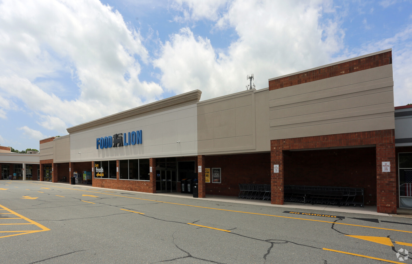
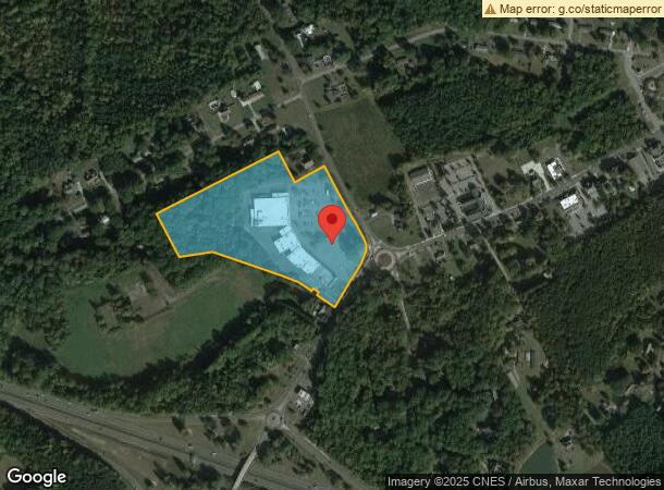
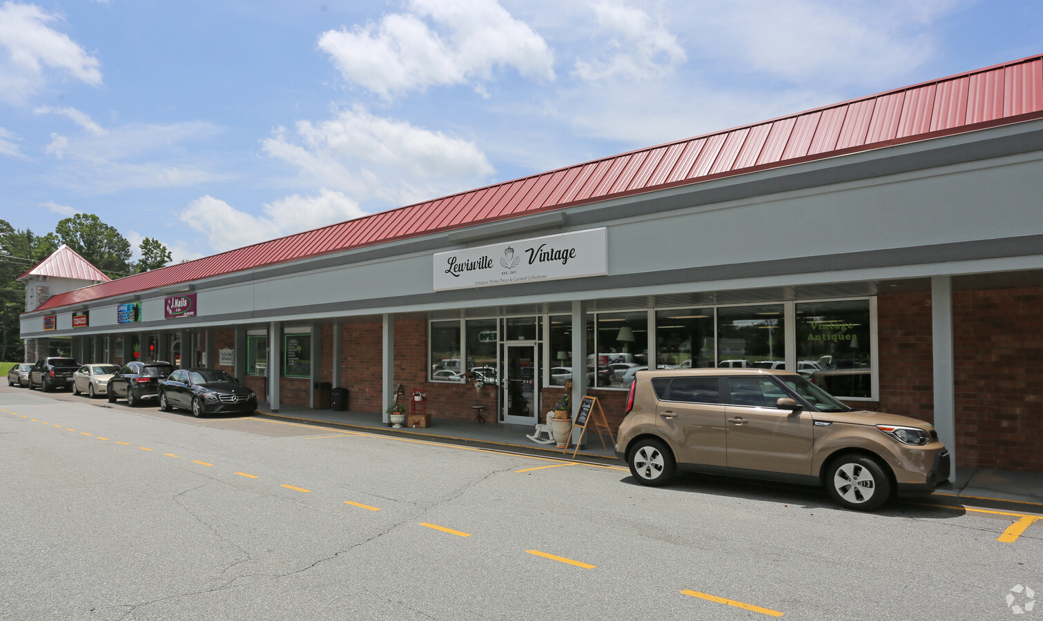
6758 Shallowford Rd
Winston-Salem, NC
Oaks At Lewisville
5875-76-6417
OAKS AT LEWISVILLE LO:302B BL:4406 BU:1
Storebuilding
Forsyth
X
North Carolina
3710587500J
302b
2023
13.40 AC
2024
Western Forsyth County
004009
Greensboro/Winston-Salem
2,365 SF
DEMOGRAPHICS near 6758 Shallowford Rd
1 Mile
3 Mile
5 Mile
2024 Total Population
2,216
17,936
52,240
2029 Population
2,318
18,744
54,389
Pop Growth 2024-2029
+ 4.60%
+ 4.50%
+ 4.11%
Average Age
42
42
42
2024 Total Households
890
6,889
21,114
HH Growth 2024-2029
+ 4.49%
+ 4.47%
+ 4.07%
Median Household Inc
$87,500
$97,729
$89,210
Avg Household Size
2.50
2.60
2.40
2024 Avg HH Vehicles
2.00
2.00
2.00
Median Home Value
$336,742
$317,221
$306,778
Median Year Built
1990
1990
1990
Nearby Places
- Restaurants
- Banks
- Shops
- Fitness
- Groceries
PUBLIC TRANSPORTATION
AIRPORT
Piedmont Triad International
DRIVE
WALK
Distance
Piedmont Triad International
45 min
31.9 mi
Freight Ports
Virginia Port Authority - Richmond
DRIVE
WALK
Distance
Virginia Port Authority - Richmond
272 min
235.6 mi
SALE & LEASE HISTORY
LISTING DATE
SALE/LEASE

Jun 28, 2017
For Lease
Nearby Properties
Address
Land Use
TOTAL SIZE
Lot Size
Zoning
Address
Land Use
TOTAL SIZE
Lot Size
Zoning
187,927 SF
20.53 AC
CD1-S
Address
Land Use
TOTAL SIZE
Lot Size
Zoning
349,983 SF
19.63 AC
HB-S
Address
Land Use
TOTAL SIZE
Lot Size
Zoning
152,991 SF
13.94 AC
HB-S
Address
Land Use
TOTAL SIZE
Lot Size
Zoning
69,984 SF
16.14 AC
RM8
Address
Land Use
TOTAL SIZE
Lot Size
Zoning
75,795 SF
8.59 AC
PB-S,RM12
Address
Land Use
TOTAL SIZE
Lot Size
Zoning
75,991 SF
8.68 AC
PB-S,RM12
Address
Land Use
TOTAL SIZE
Lot Size
Zoning
54,297 SF
8.44 AC
HB-S
Address
Land Use
TOTAL SIZE
Lot Size
Zoning
64,676 SF
10.88 AC
IP
Address
Land Use
TOTAL SIZE
Lot Size
Zoning
52,208 SF
33.17 AC
RM12
Address
Land Use
TOTAL SIZE
Lot Size
Zoning
20,616 SF
4.94 AC
PB,RS9
Address
Land Use
TOTAL SIZE
Lot Size
Zoning
12,776 SF
30.92 AC
HB-S
Address
Land Use
TOTAL SIZE
Lot Size
Zoning
22,902 SF
5.20 AC
RM12-S
Address
Land Use
TOTAL SIZE
Lot Size
Zoning
15,806 SF
3.09 AC
IP-S
Address
Land Use
TOTAL SIZE
Lot Size
Zoning
17,422 SF
2.63 AC
LD1-S
Address
Land Use
TOTAL SIZE
Lot Size
Zoning
14,190 SF
0.95 AC
IP
Address
Land Use
TOTAL SIZE
Lot Size
Zoning
37,905 SF
7.82 AC
HB,HB-S
Address
Land Use
TOTAL SIZE
Lot Size
Zoning
59,838 SF
4.86 AC
HB
Address
Land Use
TOTAL SIZE
Lot Size
Zoning
5,677 SF
0.49 AC
IP
Address
Land Use
TOTAL SIZE
Lot Size
Zoning
14,553 SF
1.68 AC
HB-S
Address
Land Use
TOTAL SIZE
Lot Size
Zoning
9,975 SF
2.15 AC
HB
Address
Land Use
TOTAL SIZE
Lot Size
Zoning
24,362 SF
7.02 AC
LB,RS9
Address
Land Use
TOTAL SIZE
Lot Size
Zoning
30,075 SF
NULL
Address
Land Use
TOTAL SIZE
Lot Size
Zoning
10,319 SF
1.79 AC
LD1-S
Address
Land Use
TOTAL SIZE
Lot Size
Zoning
11,200 SF
1.63 AC
HB-S
Address
Land Use
TOTAL SIZE
Lot Size
Zoning
34,580 SF
5.43 AC
LB-S,PB
Address
Land Use
TOTAL SIZE
Lot Size
Zoning
7,819 SF
1.45 AC
HB-S
Address
Land Use
TOTAL SIZE
Lot Size
Zoning
11,572 SF
2.39 AC
IP
Address
Land Use
TOTAL SIZE
Lot Size
Zoning
11,068 SF
0.74 AC
LD1-S
Address
Land Use
TOTAL SIZE
Lot Size
Zoning
3,007 SF
1.01 AC
HB
The World's #1 Commercial Real Estate Marketplace
Connect with us
© 2025 CoStar Group
The information above has been obtained from sources believed reliable. While we do not doubt its accuracy we have not verified it and make no guarantee, warranty or representation about it. It is your responsibility to independently confirm its accuracy and completeness. Any projections, opinions, assumptions, or estimates used are for example only and do not represent the current or future performance of the property. The value of this transaction to you depends on tax and other factors which should be evaluated by your tax, financial, and legal advisors. You and your advisors should conduct a careful, independent investigation of the property to determine to your satisfaction the suitability of the property for your needs.