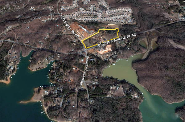
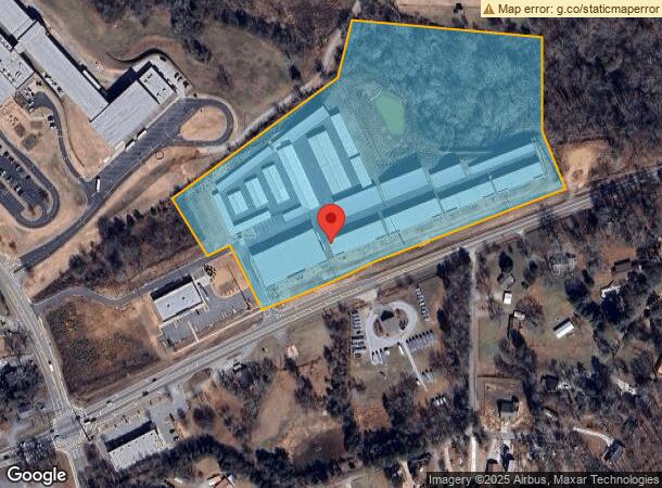
Property Record
6775 Browns Bridge Rd, Gainesville, GA 30506


NEARBY LISTINGS FOR SALE OR LEASE
Property Detail
6775 Browns Bridge Rd
Atlanta-Sandy Springs-Roswell, GA
Chattahoochee
283-200
14-1 847-877-878 TR 2
Commercialnec
Forsyth
A
Georgia
13139C0275G
13.25 AC
2024
N Fulton/Forsyth County
2024
Atlanta
130102
DEMOGRAPHICS near 6775 Browns Bridge Rd
1 Mile
3 Mile
5 Mile
2024 Total Population
2,370
14,343
37,701
2029 Population
2,773
16,805
43,972
Pop Growth 2024-2029
+ 17.00%
+ 17.17%
+ 16.63%
Average Age
43
42
41
2024 Total Households
857
5,139
13,566
HH Growth 2024-2029
+ 17.04%
+ 17.18%
+ 16.68%
Median Household Inc
$99,451
$99,193
$96,842
Avg Household Size
2.80
2.80
2.70
2024 Avg HH Vehicles
2.00
2.00
2.00
Median Home Value
$492,856
$490,635
$422,116
Median Year Built
1996
1995
1998
Nearby Places
- Restaurants
- Banks
- Shops
- Fitness
- Groceries
SALE & LEASE HISTORY
LISTING DATE
SALE/LEASE

Sep 24, 2016
For Sale
Mar 22, 2017
For Sale
Feb 27, 2017
For Sale
Feb 24, 2017
For Sale
Nearby Properties
Address
Land Use
TOTAL SIZE
Lot Size
Zoning
Address
Land Use
TOTAL SIZE
Lot Size
Zoning
250,371 SF
88.47 AC
A1
Address
Land Use
TOTAL SIZE
Lot Size
Zoning
181,442 SF
32.34 AC
A1
Address
Land Use
TOTAL SIZE
Lot Size
Zoning
80,956 SF
6.07 AC
CBD
Address
Land Use
TOTAL SIZE
Lot Size
Zoning
4,450 SF
106 AC
LR
Address
Land Use
TOTAL SIZE
Lot Size
Zoning
375 SF
154 AC
LR
Address
Land Use
TOTAL SIZE
Lot Size
Zoning
33,608 SF
3.34 AC
HB
Address
Land Use
TOTAL SIZE
Lot Size
Zoning
46,540 SF
11.10 AC
CBD
Address
Land Use
TOTAL SIZE
Lot Size
Zoning
33,376 SF
4.34 AC
M1
Address
Land Use
TOTAL SIZE
Lot Size
Zoning
3,060 SF
8.47 AC
M1
Address
Land Use
TOTAL SIZE
Lot Size
Zoning
47,453 SF
6.87 AC
CBD
Address
Land Use
TOTAL SIZE
Lot Size
Zoning
3,248 SF
LR
Address
Land Use
TOTAL SIZE
Lot Size
Zoning
6.91 AC
A1
Address
Land Use
TOTAL SIZE
Lot Size
Zoning
22,280 SF
1.94 AC
M1
Address
Land Use
TOTAL SIZE
Lot Size
Zoning
20,040 SF
2.17 AC
M1
Address
Land Use
TOTAL SIZE
Lot Size
Zoning
1,922 SF
21 AC
CBD
Address
Land Use
TOTAL SIZE
Lot Size
Zoning
1,564 SF
20.37 AC
CBD
Address
Land Use
TOTAL SIZE
Lot Size
Zoning
20,205 SF
1.33 AC
M1
Address
Land Use
TOTAL SIZE
Lot Size
Zoning
20,000 SF
1.92 AC
M1
Address
Land Use
TOTAL SIZE
Lot Size
Zoning
43,528 SF
5.08 AC
CBD
Address
Land Use
TOTAL SIZE
Lot Size
Zoning
3,779 SF
16.17 AC
A1
Address
Land Use
TOTAL SIZE
Lot Size
Zoning
30,752 SF
2.83 AC
M1
Address
Land Use
TOTAL SIZE
Lot Size
Zoning
1,758 SF
55.57 AC
A1
Address
Land Use
TOTAL SIZE
Lot Size
Zoning
7,150 SF
8.54 AC
A1
Address
Land Use
TOTAL SIZE
Lot Size
Zoning
5,318 SF
5.61 AC
A1
Address
Land Use
TOTAL SIZE
Lot Size
Zoning
99.66 AC
RES2
Address
Land Use
TOTAL SIZE
Lot Size
Zoning
14,466 SF
1.78 AC
M1
Address
Land Use
TOTAL SIZE
Lot Size
Zoning
15,846 SF
1.48 AC
CBD
Address
Land Use
TOTAL SIZE
Lot Size
Zoning
15,000 SF
1.82 AC
M1
Address
Land Use
TOTAL SIZE
Lot Size
Zoning
14,302 SF
1.43 AC
M1
The World's #1 Commercial Real Estate Marketplace
Connect with us
© 2025 CoStar Group
The information above has been obtained from sources believed reliable. While we do not doubt its accuracy we have not verified it and make no guarantee, warranty or representation about it. It is your responsibility to independently confirm its accuracy and completeness. Any projections, opinions, assumptions, or estimates used are for example only and do not represent the current or future performance of the property. The value of this transaction to you depends on tax and other factors which should be evaluated by your tax, financial, and legal advisors. You and your advisors should conduct a careful, independent investigation of the property to determine to your satisfaction the suitability of the property for your needs.