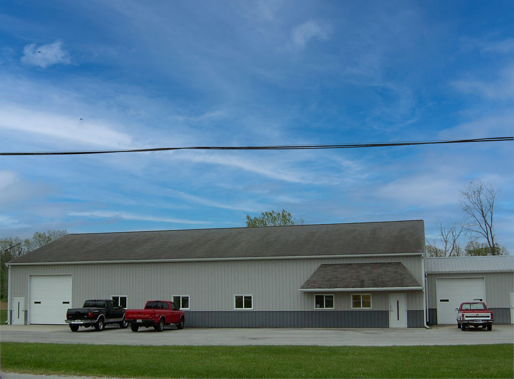
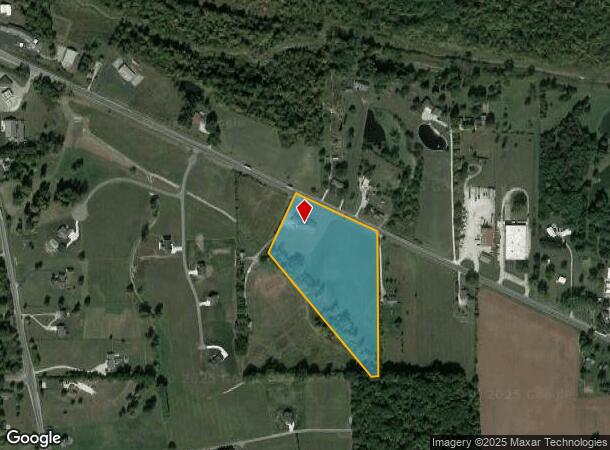
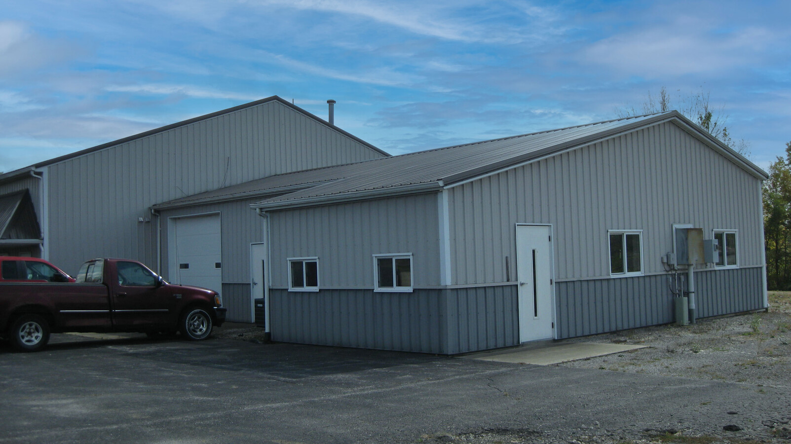
Property Record
679 W Markle Rd, Huntington, IN 46750
NEARBY LISTINGS FOR SALE OR LEASE
Property Detail
679 W Markle Rd
35-05-24-300-007.401-004
003-00074-01 PT E PT SW SEC 24 9.02 AC
Commercialnec
Huntington
X
Indiana
18069C0255D
9.02 AC
2023
Fort Wayne
2023
Other Market Areas
961700
Huntington, IN
7,062 SF
DEMOGRAPHICS near 679 W Markle Rd
1 Mile
3 Mile
5 Mile
2024 Total Population
461
16,838
22,109
2029 Population
465
17,085
22,370
Pop Growth 2024-2029
+ 0.87%
+ 1.47%
+ 1.18%
Average Age
43
40
40
2024 Total Households
199
6,840
8,934
HH Growth 2024-2029
+ 1.01%
+ 1.51%
+ 1.23%
Median Household Inc
$48,124
$48,302
$52,296
Avg Household Size
2.30
2.30
2.30
2024 Avg HH Vehicles
2.00
2.00
2.00
Median Home Value
$133,898
$84,970
$107,531
Median Year Built
1965
1949
1956
Nearby Places
- Restaurants
- Banks
- Shops
- Fitness
- Groceries
PUBLIC TRANSPORTATION
AIRPORT
Fort Wayne International
DRIVE
WALK
Distance
Fort Wayne International
33 min
22.9 mi
Freight Ports
Port of Toledo
DRIVE
WALK
Distance
Port of Toledo
167 min
133.9 mi
SALE & LEASE HISTORY
LISTING DATE
SALE/LEASE

Nov 08, 2023
For Sale
Nearby Properties
Address
Land Use
TOTAL SIZE
Lot Size
Zoning
Address
Land Use
TOTAL SIZE
Lot Size
Zoning
119,200 SF
2.17 AC
Address
Land Use
TOTAL SIZE
Lot Size
Zoning
15.96 AC
Address
Land Use
TOTAL SIZE
Lot Size
Zoning
43,916 SF
0.36 AC
Address
Land Use
TOTAL SIZE
Lot Size
Zoning
42,036 SF
0.15 AC
Address
Land Use
TOTAL SIZE
Lot Size
Zoning
225,560 SF
13.32 AC
Address
Land Use
TOTAL SIZE
Lot Size
Zoning
57,829 SF
0.72 AC
Address
Land Use
TOTAL SIZE
Lot Size
Zoning
25,284 SF
10 AC
Address
Land Use
TOTAL SIZE
Lot Size
Zoning
21,102 SF
70.94 AC
Address
Land Use
TOTAL SIZE
Lot Size
Zoning
22,180 SF
24.28 AC
Address
Land Use
TOTAL SIZE
Lot Size
Zoning
43,924 SF
0.49 AC
Address
Land Use
TOTAL SIZE
Lot Size
Zoning
45,429 SF
12.20 AC
Address
Land Use
TOTAL SIZE
Lot Size
Zoning
2,400 SF
14.24 AC
Address
Land Use
TOTAL SIZE
Lot Size
Zoning
137,514 SF
13.31 AC
Address
Land Use
TOTAL SIZE
Lot Size
Zoning
67,830 SF
0.35 AC
Address
Land Use
TOTAL SIZE
Lot Size
Zoning
30,357 SF
0.34 AC
Address
Land Use
TOTAL SIZE
Lot Size
Zoning
5,735 SF
4.46 AC
Address
Land Use
TOTAL SIZE
Lot Size
Zoning
1,728 SF
6.08 AC
Address
Land Use
TOTAL SIZE
Lot Size
Zoning
2,583 SF
8.02 AC
Address
Land Use
TOTAL SIZE
Lot Size
Zoning
47,612 SF
0.57 AC
Address
Land Use
TOTAL SIZE
Lot Size
Zoning
2,650 SF
61.32 AC
Address
Land Use
TOTAL SIZE
Lot Size
Zoning
79,160 SF
18.77 AC
Address
Land Use
TOTAL SIZE
Lot Size
Zoning
56,238 SF
4.70 AC
Address
Land Use
TOTAL SIZE
Lot Size
Zoning
27,819 SF
6.28 AC
Address
Land Use
TOTAL SIZE
Lot Size
Zoning
14,660 SF
1.37 AC
Address
Land Use
TOTAL SIZE
Lot Size
Zoning
21,776 SF
1.36 AC
Address
Land Use
TOTAL SIZE
Lot Size
Zoning
5,590 SF
2 AC
Address
Land Use
TOTAL SIZE
Lot Size
Zoning
46,846 SF
4.40 AC
Address
Land Use
TOTAL SIZE
Lot Size
Zoning
50,000 SF
5.97 AC
Address
Land Use
TOTAL SIZE
Lot Size
Zoning
78,437 SF
3.60 AC
Address
Land Use
TOTAL SIZE
Lot Size
Zoning
14,000 SF
13.93 AC
The World's #1 Commercial Real Estate Marketplace
Connect with us
© 2025 CoStar Group
The information above has been obtained from sources believed reliable. While we do not doubt its accuracy we have not verified it and make no guarantee, warranty or representation about it. It is your responsibility to independently confirm its accuracy and completeness. Any projections, opinions, assumptions, or estimates used are for example only and do not represent the current or future performance of the property. The value of this transaction to you depends on tax and other factors which should be evaluated by your tax, financial, and legal advisors. You and your advisors should conduct a careful, independent investigation of the property to determine to your satisfaction the suitability of the property for your needs.