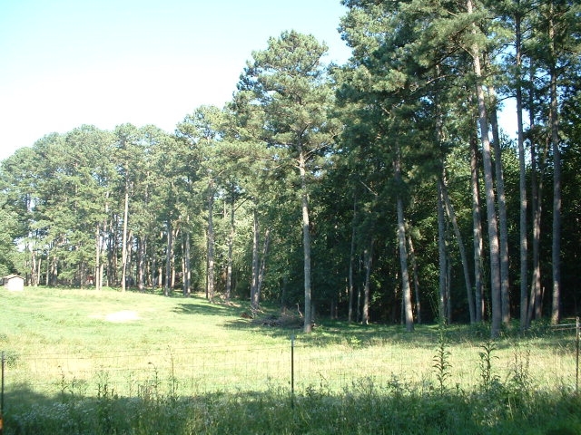
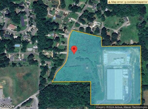
Property Record
680 Peek Rd Se, Dalton, GA 30721
NEARBY LISTINGS FOR SALE OR LEASE
-
-
View all Dalton listings for sale on LoopNet.com
Property Detail
680 Peek Rd Se
13-012-36-000
Comm Land 25000 Ac
Warehouse
14.14A LL12 13
X
Whitfield
13213C0200D
Georgia
2024
14.14 AC
2023
Georgia Northwest
001200
Other Market Areas
80,000 SF
Dalton, GA
DEMOGRAPHICS near 680 Peek Rd Se
1 Mile
3 Mile
5 Mile
2024 Total Population
2,126
14,421
46,581
2029 Population
2,158
14,514
46,754
Pop Growth 2024-2029
+ 1.51%
+ 0.64%
+ 0.37%
Average Age
36
36
37
2024 Total Households
691
4,756
15,837
HH Growth 2024-2029
+ 1.45%
+ 0.57%
+ 0.37%
Median Household Inc
$48,481
$47,079
$46,362
Avg Household Size
3.00
3.00
2.90
2024 Avg HH Vehicles
2.00
2.00
2.00
Median Home Value
$92,092
$154,763
$163,778
Median Year Built
1986
1983
1982
Nearby Places
- Restaurants
- Banks
- Shops
- Fitness
- Groceries
PUBLIC TRANSPORTATION
AIRPORT
Lovell Field
Drive
Walk
Distance
Lovell Field
48 min
33.6 mi
Freight Ports
Georgia Ports - Savannah
Drive
Walk
Distance
Georgia Ports - Savannah
375 min
333.7 mi
Nearby Properties
Address
Land Use
TOTAL SIZE
Lot Size
Zoning
Address
Land Use
TOTAL SIZE
Lot Size
Zoning
193120
41.95 AC
Address
Land Use
TOTAL SIZE
Lot Size
Zoning
662926
67.28 AC
Address
Land Use
TOTAL SIZE
Lot Size
Zoning
513638
61.78 AC
Address
Land Use
TOTAL SIZE
Lot Size
Zoning
433597
36.86 AC
Address
Land Use
TOTAL SIZE
Lot Size
Zoning
200000
15.18 AC
M-2
Address
Land Use
TOTAL SIZE
Lot Size
Zoning
1183067
48.97 AC
Address
Land Use
TOTAL SIZE
Lot Size
Zoning
189280
8.18 AC
M-2
Address
Land Use
TOTAL SIZE
Lot Size
Zoning
193716
29.23 AC
Address
Land Use
TOTAL SIZE
Lot Size
Zoning
174347
87.57 AC
Address
Land Use
TOTAL SIZE
Lot Size
Zoning
38016
18 AC
Address
Land Use
TOTAL SIZE
Lot Size
Zoning
747587
24.63 AC
Address
Land Use
TOTAL SIZE
Lot Size
Zoning
341549
25.46 AC
Address
Land Use
TOTAL SIZE
Lot Size
Zoning
1125548
24.22 AC
Address
Land Use
TOTAL SIZE
Lot Size
Zoning
243100
27.04 AC
Address
Land Use
TOTAL SIZE
Lot Size
Zoning
261000
9.88 AC
Address
Land Use
TOTAL SIZE
Lot Size
Zoning
209000
19.58 AC
Address
Land Use
TOTAL SIZE
Lot Size
Zoning
471045
45.93 AC
Address
Land Use
TOTAL SIZE
Lot Size
Zoning
450292
23.87 AC
Address
Land Use
TOTAL SIZE
Lot Size
Zoning
55584
21.34 AC
Address
Land Use
TOTAL SIZE
Lot Size
Zoning
541013
21.88 AC
Address
Land Use
TOTAL SIZE
Lot Size
Zoning
255350
18.64 AC
Address
Land Use
TOTAL SIZE
Lot Size
Zoning
337431
14.51 AC
Address
Land Use
TOTAL SIZE
Lot Size
Zoning
184000
29.32 AC
Address
Land Use
TOTAL SIZE
Lot Size
Zoning
234696
41.91 AC
Address
Land Use
TOTAL SIZE
Lot Size
Zoning
299446
10.50 AC
Address
Land Use
TOTAL SIZE
Lot Size
Zoning
355274
17.41 AC
Address
Land Use
TOTAL SIZE
Lot Size
Zoning
337368
13.46 AC
Address
Land Use
TOTAL SIZE
Lot Size
Zoning
154660
24.70 AC
M-2
Address
Land Use
TOTAL SIZE
Lot Size
Zoning
211114
16.09 AC
Address
Land Use
TOTAL SIZE
Lot Size
Zoning
276936
37.08 AC
Start a new search to find other properties for sale or lease
Connect with us
© 2024 CoStar Group
The information above has been obtained from sources believed reliable. While we do not doubt its accuracy we have not verified it and make no guarantee, warranty or representation about it. It is your responsibility to independently confirm its accuracy and completeness. Any projections, opinions, assumptions, or estimates used are for example only and do not represent the current or future performance of the property. The value of this transaction to you depends on tax and other factors which should be evaluated by your tax, financial, and legal advisors. You and your advisors should conduct a careful, independent investigation of the property to determine to your satisfaction the suitability of the property for your needs.