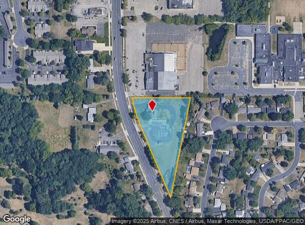
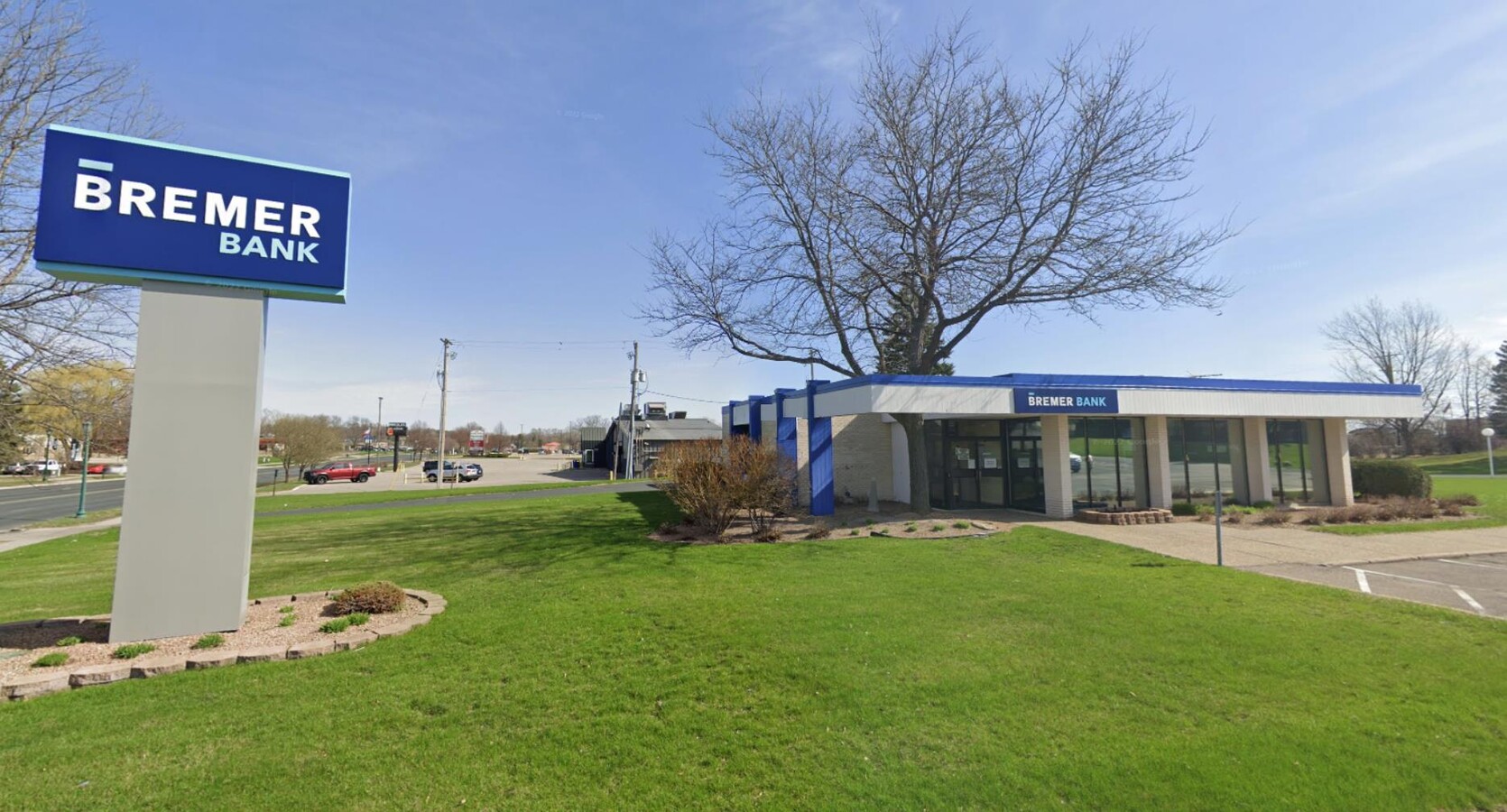
Property Record
6800 Cahill Ave, Inver Grove Heights, MN 55076

NEARBY LISTINGS FOR SALE OR LEASE
Property Detail
6800 Cahill Ave
Minneapolis-St. Paul-Bloomington, MN-WI
South Grove No 11
20-71160-00-010
SOUTH GROVE NO 11 A OUTLOT
Commercialnec
Dakota
X
Minnesota
27037C0110E
10
2024
2.17 AC
2023
Eagan
060502
Minneapolis/St Paul
2,369 SF
DEMOGRAPHICS near 6800 Cahill Ave
1 Mile
3 Mile
5 Mile
2024 Total Population
8,714
53,864
122,781
2029 Population
8,842
55,440
127,384
Pop Growth 2024-2029
+ 1.47%
+ 2.93%
+ 3.75%
Average Age
43
40
40
2024 Total Households
3,628
21,989
48,237
HH Growth 2024-2029
+ 1.43%
+ 2.87%
+ 3.68%
Median Household Inc
$83,387
$77,071
$85,986
Avg Household Size
2.30
2.40
2.50
2024 Avg HH Vehicles
2.00
2.00
2.00
Median Home Value
$289,291
$282,864
$307,327
Median Year Built
1980
1979
1981
Nearby Places
- Restaurants
- Banks
- Shops
- Fitness
- Groceries
PUBLIC TRANSPORTATION
COMMUTER RAIL
St. Paul-Minneapolis (Empire Builder - Amtrak)
DRIVE
WALK
Distance
St. Paul-Minneapolis (Empire Builder - Amtrak)
14 min
9.1 mi
AIRPORT
Minneapolis-St Paul International/Wold-Chamberlain
DRIVE
WALK
Distance
Minneapolis-St Paul International/Wold-Chamberlain
20 min
11.8 mi
Freight Ports
Port Milwaukee
DRIVE
WALK
Distance
Port Milwaukee
365 min
330.9 mi
SALE & LEASE HISTORY
LISTING DATE
SALE/LEASE

Jul 28, 2022
For Sale
Nearby Properties
Address
Land Use
TOTAL SIZE
Lot Size
Zoning
Address
Land Use
TOTAL SIZE
Lot Size
Zoning
Address
Land Use
TOTAL SIZE
Lot Size
Zoning
228,050 SF
0.32 AC
Address
Land Use
TOTAL SIZE
Lot Size
Zoning
284,876 SF
29.54 AC
Address
Land Use
TOTAL SIZE
Lot Size
Zoning
169,237 SF
23.38 AC
Address
Land Use
TOTAL SIZE
Lot Size
Zoning
191,349 SF
5.10 AC
Address
Land Use
TOTAL SIZE
Lot Size
Zoning
227,382 SF
13.14 AC
Address
Land Use
TOTAL SIZE
Lot Size
Zoning
174,820 SF
7.79 AC
Address
Land Use
TOTAL SIZE
Lot Size
Zoning
111,595 SF
2.24 AC
Address
Land Use
TOTAL SIZE
Lot Size
Zoning
128,798 SF
4.22 AC
Address
Land Use
TOTAL SIZE
Lot Size
Zoning
147,944 SF
5.17 AC
Address
Land Use
TOTAL SIZE
Lot Size
Zoning
98,138 SF
2.12 AC
Address
Land Use
TOTAL SIZE
Lot Size
Zoning
219,438 SF
90.20 AC
Address
Land Use
TOTAL SIZE
Lot Size
Zoning
106,040 SF
5.70 AC
Address
Land Use
TOTAL SIZE
Lot Size
Zoning
143,712 SF
9.57 AC
Address
Land Use
TOTAL SIZE
Lot Size
Zoning
290,362 SF
12.83 AC
Address
Land Use
TOTAL SIZE
Lot Size
Zoning
117,784 SF
1.86 AC
Address
Land Use
TOTAL SIZE
Lot Size
Zoning
64,860 SF
2.65 AC
Address
Land Use
TOTAL SIZE
Lot Size
Zoning
67,370 SF
1.18 AC
Address
Land Use
TOTAL SIZE
Lot Size
Zoning
87,080 SF
2.16 AC
Address
Land Use
TOTAL SIZE
Lot Size
Zoning
95,693 SF
3.64 AC
Address
Land Use
TOTAL SIZE
Lot Size
Zoning
185,715 SF
11.50 AC
Address
Land Use
TOTAL SIZE
Lot Size
Zoning
63,311 SF
6.23 AC
Address
Land Use
TOTAL SIZE
Lot Size
Zoning
110,256 SF
4.04 AC
Address
Land Use
TOTAL SIZE
Lot Size
Zoning
108,000 SF
6.44 AC
Address
Land Use
TOTAL SIZE
Lot Size
Zoning
130,171 SF
10.22 AC
Address
Land Use
TOTAL SIZE
Lot Size
Zoning
161,676 SF
13.90 AC
Address
Land Use
TOTAL SIZE
Lot Size
Zoning
141,090 SF
16.79 AC
Address
Land Use
TOTAL SIZE
Lot Size
Zoning
72,350 SF
1.86 AC
Address
Land Use
TOTAL SIZE
Lot Size
Zoning
86,527 SF
10.21 AC
Address
Land Use
TOTAL SIZE
Lot Size
Zoning
201,558 SF
10.85 AC
The World's #1 Commercial Real Estate Marketplace
Connect with us
© 2025 CoStar Group
The information above has been obtained from sources believed reliable. While we do not doubt its accuracy we have not verified it and make no guarantee, warranty or representation about it. It is your responsibility to independently confirm its accuracy and completeness. Any projections, opinions, assumptions, or estimates used are for example only and do not represent the current or future performance of the property. The value of this transaction to you depends on tax and other factors which should be evaluated by your tax, financial, and legal advisors. You and your advisors should conduct a careful, independent investigation of the property to determine to your satisfaction the suitability of the property for your needs.