Property Record
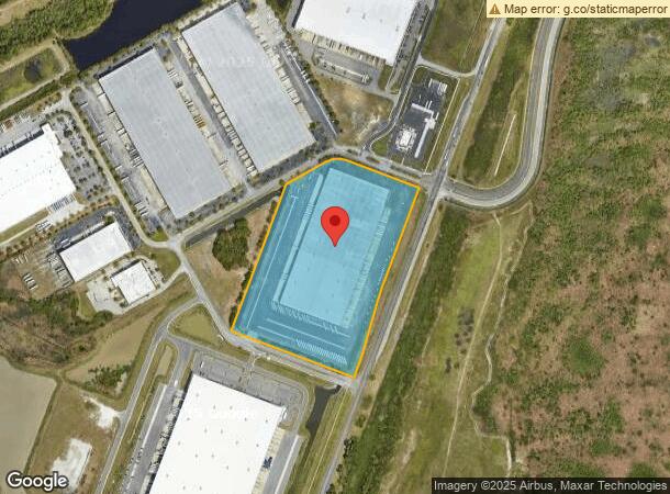
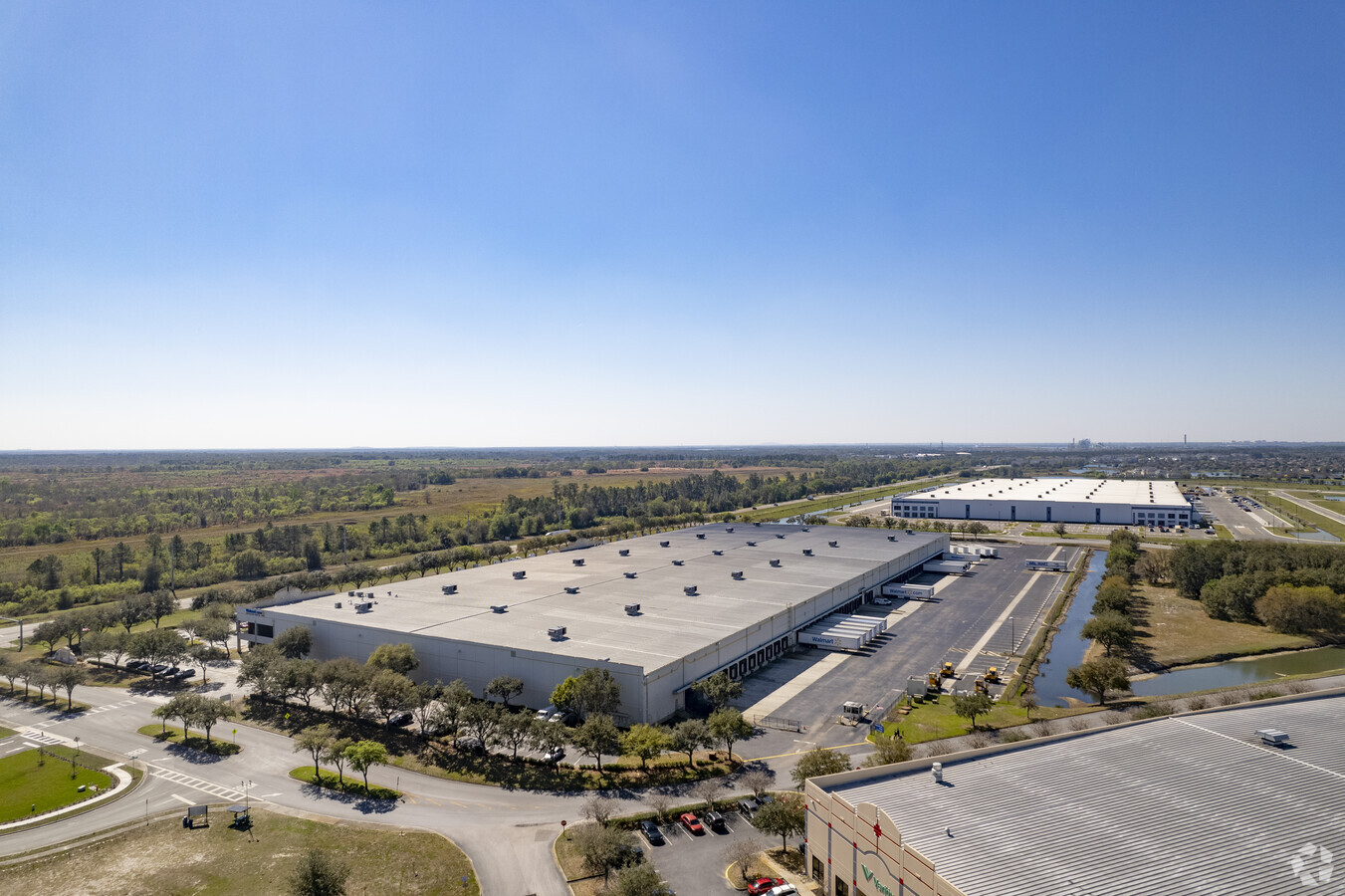
6800 State Road 33 N, Lakeland, FL 33805

NEARBY LISTINGS FOR SALE OR LEASE
Property Detail
6800 State Road 33 N
Lakeland-Winter Haven, FL
First Park At Bridgewater Phase One
24-27-15-161081-000010
FIRST PARK AT BRIDGEWATER PHASE ONE PB 117 PG 4 LOT 1 LESS THAT PT LYING WITHIN FIRST PARK BLVD AS SHOWN IN PB 127 PGS 38-39
Warehouse
Polk
X
Florida
12105C0170G
1
2023
22.39 AC
2023
Polk County
011400
Tampa/St Petersburg
359,142 SF
DEMOGRAPHICS near 6800 State Road 33 N
1 Mile
3 Mile
5 Mile
2024 Total Population
1,312
21,698
57,824
2029 Population
1,578
25,899
69,211
Pop Growth 2024-2029
+ 20.27%
+ 19.36%
+ 19.69%
Average Age
40
42
42
2024 Total Households
468
8,514
22,691
HH Growth 2024-2029
+ 20.30%
+ 19.36%
+ 19.63%
Median Household Inc
$97,169
$69,376
$57,945
Avg Household Size
2.80
2.50
2.50
2024 Avg HH Vehicles
2.00
2.00
2.00
Median Home Value
$283,103
$219,109
$198,666
Median Year Built
2003
1993
1990
Nearby Places
- Restaurants
- Banks
- Shops
- Fitness
- Groceries
PUBLIC TRANSPORTATION
COMMUTER RAIL
Lakeland (Silver Star - Amtrak)
DRIVE
WALK
Distance
Lakeland (Silver Star - Amtrak)
15 min
8.2 mi
Freight Ports
Port of Tampa Bay
DRIVE
WALK
Distance
Port of Tampa Bay
51 min
40.7 mi
SALE & LEASE HISTORY
LISTING DATE
SALE/LEASE

Jan 07, 2019
For Lease
Nearby Properties
Address
Land Use
TOTAL SIZE
Lot Size
Zoning
Address
Land Use
TOTAL SIZE
Lot Size
Zoning
1,004,929 SF
138.29 AC
RC
Address
Land Use
TOTAL SIZE
Lot Size
Zoning
1,013,375 SF
59.99 AC
Address
Land Use
TOTAL SIZE
Lot Size
Zoning
710,790 SF
59.77 AC
PUD
Address
Land Use
TOTAL SIZE
Lot Size
Zoning
470,032 SF
23.21 AC
Address
Land Use
TOTAL SIZE
Lot Size
Zoning
605,400 SF
60.58 AC
RC
Address
Land Use
TOTAL SIZE
Lot Size
Zoning
358,929 SF
65.46 AC
XX
Address
Land Use
TOTAL SIZE
Lot Size
Zoning
537,608 SF
42.33 AC
RC
Address
Land Use
TOTAL SIZE
Lot Size
Zoning
245,853 SF
20.09 AC
Address
Land Use
TOTAL SIZE
Lot Size
Zoning
430,813 SF
43.97 AC
RC
Address
Land Use
TOTAL SIZE
Lot Size
Zoning
400,000 SF
34.90 AC
Address
Land Use
TOTAL SIZE
Lot Size
Zoning
400,000 SF
18.51 AC
Address
Land Use
TOTAL SIZE
Lot Size
Zoning
338,930 SF
24.33 AC
Address
Land Use
TOTAL SIZE
Lot Size
Zoning
301,940 SF
21.85 AC
RE1
Address
Land Use
TOTAL SIZE
Lot Size
Zoning
324,191 SF
23.37 AC
PUD
Address
Land Use
TOTAL SIZE
Lot Size
Zoning
275,184 SF
16.32 AC
Address
Land Use
TOTAL SIZE
Lot Size
Zoning
139,302 SF
16.50 AC
RC
Address
Land Use
TOTAL SIZE
Lot Size
Zoning
89,879 SF
13.48 AC
C4
Address
Land Use
TOTAL SIZE
Lot Size
Zoning
100,740 SF
17.62 AC
RC
Address
Land Use
TOTAL SIZE
Lot Size
Zoning
132,600 SF
14.62 AC
Address
Land Use
TOTAL SIZE
Lot Size
Zoning
129,480 SF
12.32 AC
RE1
Address
Land Use
TOTAL SIZE
Lot Size
Zoning
61,000 SF
9 AC
PUD
Address
Land Use
TOTAL SIZE
Lot Size
Zoning
80,000 SF
9.76 AC
Address
Land Use
TOTAL SIZE
Lot Size
Zoning
30,429 SF
5.95 AC
Address
Land Use
TOTAL SIZE
Lot Size
Zoning
49,600 SF
5 AC
Address
Land Use
TOTAL SIZE
Lot Size
Zoning
56,203 SF
43.81 AC
C3
Address
Land Use
TOTAL SIZE
Lot Size
Zoning
28,350 SF
15.97 AC
Address
Land Use
TOTAL SIZE
Lot Size
Zoning
29,855 SF
7.76 AC
RC
Address
Land Use
TOTAL SIZE
Lot Size
Zoning
4,650 SF
4.01 AC
Address
Land Use
TOTAL SIZE
Lot Size
Zoning
47,580 SF
7.16 AC
The World's #1 Commercial Real Estate Marketplace
Connect with us
© 2025 CoStar Group
The information above has been obtained from sources believed reliable. While we do not doubt its accuracy we have not verified it and make no guarantee, warranty or representation about it. It is your responsibility to independently confirm its accuracy and completeness. Any projections, opinions, assumptions, or estimates used are for example only and do not represent the current or future performance of the property. The value of this transaction to you depends on tax and other factors which should be evaluated by your tax, financial, and legal advisors. You and your advisors should conduct a careful, independent investigation of the property to determine to your satisfaction the suitability of the property for your needs.