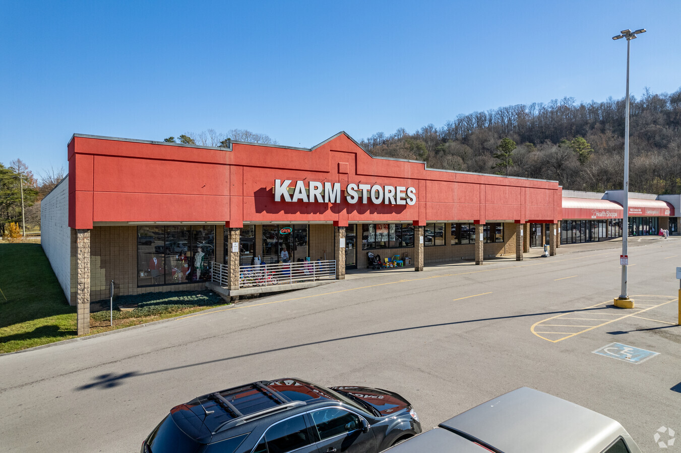
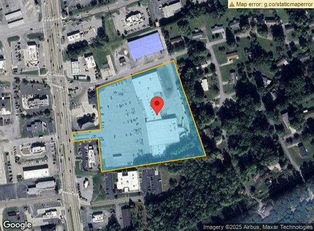
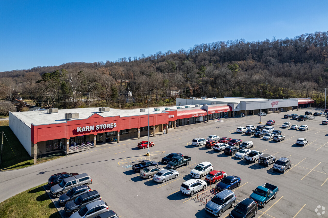
Property Record
6808 Maynardville Pike, Knoxville, TN 37918
NEARBY LISTINGS FOR SALE OR LEASE
-
-
View all Knoxville listings for sale on LoopNet.com
Property Detail
6808 Maynardville Pike
Knoxville, TN
Halls Crossing Ltd
038MA-001
SUBDIVISIONNAME HALLS CROSSING LTD MAPPLATB L230 MAPPLA TP B DIMENSIONS 52 X 180 X IRR
Storebuilding
Knox
X
Tennessee
47093C0133G
3
2024
7.46 AC
2024
North/Broadway
006203
Knoxville
62,931 SF
DEMOGRAPHICS near 6808 Maynardville Pike
1 Mile
3 Mile
5 Mile
2024 Total Population
5,248
41,833
97,414
2029 Population
5,701
45,385
105,611
Pop Growth 2024-2029
+ 8.63%
+ 8.49%
+ 8.41%
Average Age
41
42
41
2024 Total Households
2,176
16,926
40,622
HH Growth 2024-2029
+ 8.64%
+ 8.57%
+ 8.50%
Median Household Inc
$51,667
$68,578
$60,321
Avg Household Size
2.40
2.40
2.30
2024 Avg HH Vehicles
2.00
2.00
2.00
Median Home Value
$196,218
$245,561
$220,841
Median Year Built
1978
1986
1982
Nearby Places
- Restaurants
- Banks
- Shops
- Fitness
- Groceries
PUBLIC TRANSPORTATION
AIRPORT
McGhee Tyson
DRIVE
WALK
Distance
McGhee Tyson
43 min
23.5 mi
Freight Ports
North Charleston Terminal
DRIVE
WALK
Distance
North Charleston Terminal
424 min
367.1 mi
Nearby Properties
Address
Land Use
TOTAL SIZE
Lot Size
Zoning
Address
Land Use
TOTAL SIZE
Lot Size
Zoning
3,196 SF
28.14 AC
Address
Land Use
TOTAL SIZE
Lot Size
Zoning
2,700 SF
22.24 AC
Address
Land Use
TOTAL SIZE
Lot Size
Zoning
190,010 SF
22.70 AC
Address
Land Use
TOTAL SIZE
Lot Size
Zoning
54,851 SF
6.94 AC
Address
Land Use
TOTAL SIZE
Lot Size
Zoning
59,410 SF
6 AC
Address
Land Use
TOTAL SIZE
Lot Size
Zoning
82,739 SF
7.95 AC
Address
Land Use
TOTAL SIZE
Lot Size
Zoning
83,628 SF
9.51 AC
Address
Land Use
TOTAL SIZE
Lot Size
Zoning
65,429 SF
19.72 AC
Address
Land Use
TOTAL SIZE
Lot Size
Zoning
92,010 SF
1.44 AC
Address
Land Use
TOTAL SIZE
Lot Size
Zoning
37,688 SF
5.81 AC
Address
Land Use
TOTAL SIZE
Lot Size
Zoning
4,284 SF
1.62 AC
Address
Land Use
TOTAL SIZE
Lot Size
Zoning
22,600 SF
13.63 AC
Address
Land Use
TOTAL SIZE
Lot Size
Zoning
8,526 SF
7.18 AC
Address
Land Use
TOTAL SIZE
Lot Size
Zoning
5,856 SF
17.60 AC
Address
Land Use
TOTAL SIZE
Lot Size
Zoning
34,166 SF
6.94 AC
Address
Land Use
TOTAL SIZE
Lot Size
Zoning
48,759 SF
4.43 AC
Address
Land Use
TOTAL SIZE
Lot Size
Zoning
816 SF
9.33 AC
Address
Land Use
TOTAL SIZE
Lot Size
Zoning
36,512 SF
3.29 AC
Address
Land Use
TOTAL SIZE
Lot Size
Zoning
57,818 SF
13.74 AC
Address
Land Use
TOTAL SIZE
Lot Size
Zoning
13,620 SF
3.08 AC
Address
Land Use
TOTAL SIZE
Lot Size
Zoning
93.40 AC
Address
Land Use
TOTAL SIZE
Lot Size
Zoning
13,366 SF
1.68 AC
Address
Land Use
TOTAL SIZE
Lot Size
Zoning
5,910 SF
7.40 AC
Address
Land Use
TOTAL SIZE
Lot Size
Zoning
25,680 SF
6.92 AC
Address
Land Use
TOTAL SIZE
Lot Size
Zoning
31,504 SF
4.90 AC
Address
Land Use
TOTAL SIZE
Lot Size
Zoning
31,241 SF
1.20 AC
Address
Land Use
TOTAL SIZE
Lot Size
Zoning
85,553 SF
7.46 AC
Address
Land Use
TOTAL SIZE
Lot Size
Zoning
132,093 SF
9.83 AC
Address
Land Use
TOTAL SIZE
Lot Size
Zoning
940 SF
7 AC
Address
Land Use
TOTAL SIZE
Lot Size
Zoning
44,874 SF
6.28 AC
The World's #1 Commercial Real Estate Marketplace
Connect with us
© 2025 CoStar Group
The information above has been obtained from sources believed reliable. While we do not doubt its accuracy we have not verified it and make no guarantee, warranty or representation about it. It is your responsibility to independently confirm its accuracy and completeness. Any projections, opinions, assumptions, or estimates used are for example only and do not represent the current or future performance of the property. The value of this transaction to you depends on tax and other factors which should be evaluated by your tax, financial, and legal advisors. You and your advisors should conduct a careful, independent investigation of the property to determine to your satisfaction the suitability of the property for your needs.