Property Record
6900 Corporation Pky, Battleboro, NC 27809
NEARBY LISTINGS FOR SALE OR LEASE
-
-
View all Battleboro listings for sale on LoopNet.com
Property Detail
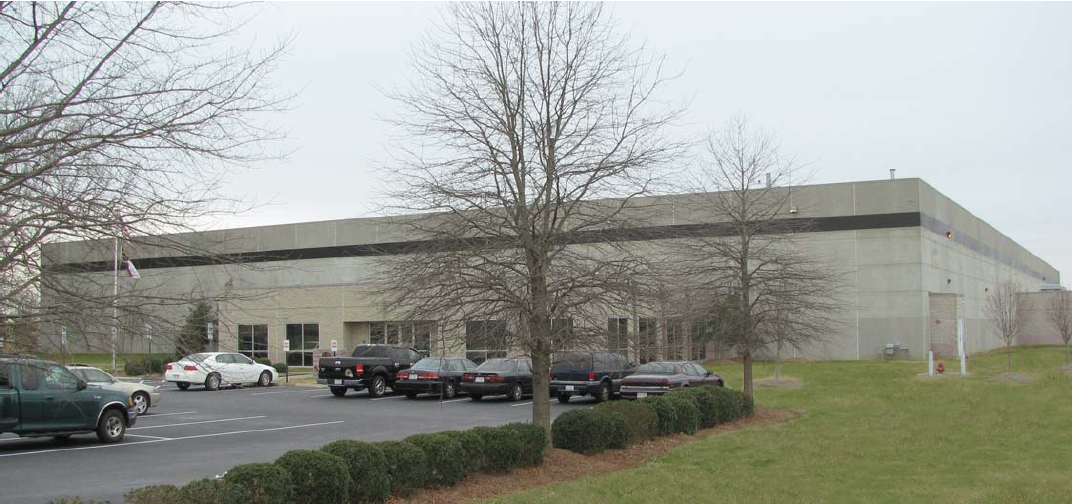
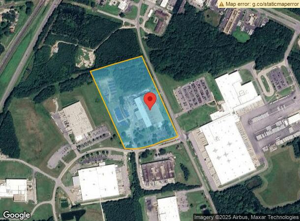
6900 Corporation Pky
3844-00-81-6800
Map Of Recombination
Manufacturinglight
MB1886 PG399
X
Nash
3720384400K
North Carolina
2024
17.98 AC
2024
Rocky Mount/Wilson
010700
Other Market Areas
105,673 SF
Rocky Mount, NC
DEMOGRAPHICS near 6900 Corporation Pky
1 Mile
3 Mile
5 Mile
2024 Total Population
154
1,671
13,452
2029 Population
158
1,730
13,810
Pop Growth 2024-2029
+ 2.60%
+ 3.53%
+ 2.66%
Average Age
43
44
41
2024 Total Households
62
700
5,655
HH Growth 2024-2029
+ 1.61%
+ 3.57%
+ 2.69%
Median Household Inc
$155,208
$72,272
$61,265
Avg Household Size
2.50
2.40
2.30
2024 Avg HH Vehicles
3.00
3.00
2.00
Median Home Value
$238,889
$205,963
$156,354
Median Year Built
1992
1991
1986
Nearby Places
- Restaurants
- Banks
- Shops
- Fitness
- Groceries
PUBLIC TRANSPORTATION
COMMUTER RAIL
Rocky Mount (Carolinian - Amtrak, Palmetto - Amtrak, Silver Meteor - Amtrak, Silver Star - Amtrak)
DRIVE
WALK
Distance
Rocky Mount (Carolinian - Amtrak, Palmetto - Amtrak, Silver Meteor - Amtrak, Silver Star - Amtrak)
16 min
9.1 mi
Freight Ports
Virginia Port Authority - Richmond
DRIVE
WALK
Distance
Virginia Port Authority - Richmond
123 min
108.0 mi
Nearby Properties
Address
Land Use
TOTAL SIZE
Lot Size
Zoning
Address
Land Use
TOTAL SIZE
Lot Size
Zoning
25,099 SF
105.61 AC
GC
Address
Land Use
TOTAL SIZE
Lot Size
Zoning
36,151 SF
23.17 AC
R30
Address
Land Use
TOTAL SIZE
Lot Size
Zoning
96,000 SF
14.65 AC
PI
Address
Land Use
TOTAL SIZE
Lot Size
Zoning
88,822 SF
20 AC
PIR30
Address
Land Use
TOTAL SIZE
Lot Size
Zoning
100,472 SF
9.71 AC
MI
Address
Land Use
TOTAL SIZE
Lot Size
Zoning
108,070 SF
15.82 AC
PIR30
Address
Land Use
TOTAL SIZE
Lot Size
Zoning
38,400 SF
14.06 AC
Address
Land Use
TOTAL SIZE
Lot Size
Zoning
648 SF
431.28 AC
GI
Address
Land Use
TOTAL SIZE
Lot Size
Zoning
22,990 SF
1.93 AC
FI
Address
Land Use
TOTAL SIZE
Lot Size
Zoning
20,700 SF
4.78 AC
GC
Address
Land Use
TOTAL SIZE
Lot Size
Zoning
1,800 SF
13.91 AC
GI
Address
Land Use
TOTAL SIZE
Lot Size
Zoning
1,400 SF
91.48 AC
PDRCU
Address
Land Use
TOTAL SIZE
Lot Size
Zoning
10,858 SF
10.56 AC
R30
Address
Land Use
TOTAL SIZE
Lot Size
Zoning
48.61 AC
R30
Address
Land Use
TOTAL SIZE
Lot Size
Zoning
18,302 SF
1.25 AC
FI
Address
Land Use
TOTAL SIZE
Lot Size
Zoning
3,655 SF
1.28 AC
B2
Address
Land Use
TOTAL SIZE
Lot Size
Zoning
200.88 AC
PDRCU
Address
Land Use
TOTAL SIZE
Lot Size
Zoning
8,430 SF
6.15 AC
FI
Address
Land Use
TOTAL SIZE
Lot Size
Zoning
44,960 SF
2.37 AC
FI
Address
Land Use
TOTAL SIZE
Lot Size
Zoning
17,694 SF
1.23 AC
FI
Address
Land Use
TOTAL SIZE
Lot Size
Zoning
8,595 SF
1.97 AC
I2CU
Address
Land Use
TOTAL SIZE
Lot Size
Zoning
56,482 SF
3.29 AC
FI
Address
Land Use
TOTAL SIZE
Lot Size
Zoning
5,000 SF
0.72 AC
FI
Address
Land Use
TOTAL SIZE
Lot Size
Zoning
1,300 SF
2.36 AC
GC
Address
Land Use
TOTAL SIZE
Lot Size
Zoning
1,985 SF
5.36 AC
FI
Address
Land Use
TOTAL SIZE
Lot Size
Zoning
4,800 SF
2.55 AC
GC
Address
Land Use
TOTAL SIZE
Lot Size
Zoning
64,138 SF
4.58 AC
FI
Address
Land Use
TOTAL SIZE
Lot Size
Zoning
21.84 AC
GC
Address
Land Use
TOTAL SIZE
Lot Size
Zoning
7,038 SF
2.52 AC
R30
The World's #1 Commercial Real Estate Marketplace
Connect with us
© 2025 CoStar Group
The information above has been obtained from sources believed reliable. While we do not doubt its accuracy we have not verified it and make no guarantee, warranty or representation about it. It is your responsibility to independently confirm its accuracy and completeness. Any projections, opinions, assumptions, or estimates used are for example only and do not represent the current or future performance of the property. The value of this transaction to you depends on tax and other factors which should be evaluated by your tax, financial, and legal advisors. You and your advisors should conduct a careful, independent investigation of the property to determine to your satisfaction the suitability of the property for your needs.