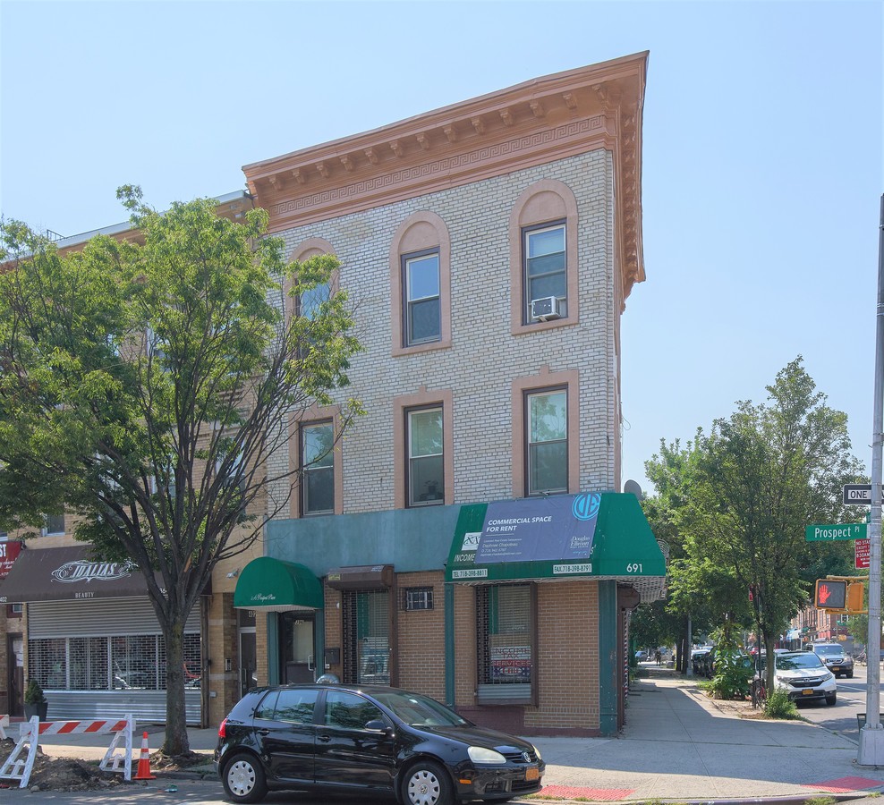
Property Record
691 Washington Ave, Brooklyn, NY 11238

NEARBY LISTINGS FOR SALE OR LEASE
Property Detail
691 Washington Ave
01161-0007
DOCID-2020071600358001
Retailwithmorethanonenonretailuse
Kings
X
New York
3604970212F
7
2024
0.03 AC
2024
North Brooklyn
020500
Long Island (New York)
2,760 SF
New York-Jersey City-White Plains, NY-NJ
DEMOGRAPHICS near 691 Washington Ave
1 Mile
3 Mile
5 Mile
2024 Total Population
176,909
1,313,424
2,774,113
2029 Population
168,818
1,243,759
2,594,204
Pop Growth 2024-2029
(4.57%)
(5.30%)
(6.49%)
Average Age
38
38
38
2024 Total Households
77,419
510,255
1,086,737
HH Growth 2024-2029
(5.10%)
(5.71%)
(6.74%)
Median Household Inc
$104,711
$75,410
$79,169
Avg Household Size
2.20
2.50
2.40
2024 Avg HH Vehicles
.00
.00
.00
Median Home Value
$1,048,349
$953,700
$878,037
Median Year Built
1947
1948
1948
Nearby Places
- Restaurants
- Banks
- Shops
- Fitness
- Groceries
PUBLIC TRANSPORTATION
TRANSIT/SUBWAY
Park Place (S Line) (Franklin Avenue Shuttle - New York MTA Subway (The Subway))
DRIVE
WALK
Distance
Park Place (S Line) (Franklin Avenue Shuttle - New York MTA Subway (The Subway))
1 min
7 min
0.3 mi
Eastern Parkway-Brooklyn Museum (2 - New York MTA Subway (The Subway), 3 - New York MTA Subway (The Subway), 4 - New York MTA Subway (The Subway))
DRIVE
WALK
Distance
Eastern Parkway-Brooklyn Museum (2 - New York MTA Subway (The Subway), 3 - New York MTA Subway (The Subway), 4 - New York MTA Subway (The Subway))
1 min
8 min
0.4 mi
Botanic Garden (Franklin Avenue Shuttle - New York MTA Subway (The Subway))
DRIVE
WALK
Distance
Botanic Garden (Franklin Avenue Shuttle - New York MTA Subway (The Subway))
1 min
10 min
0.5 mi
Grand Army Plaza (2 - New York MTA Subway (The Subway), 3 - New York MTA Subway (The Subway), 4 - New York MTA Subway (The Subway))
DRIVE
WALK
Distance
Grand Army Plaza (2 - New York MTA Subway (The Subway), 3 - New York MTA Subway (The Subway), 4 - New York MTA Subway (The Subway))
2 min
10 min
0.5 mi
Franklin Avenue (2,3,4,5 Line) (2 - New York MTA Subway (The Subway), 3 - New York MTA Subway (The Subway), 4 - New York MTA Subway (The Subway), 5 - New York MTA Subway (The Subway))
DRIVE
WALK
Distance
Franklin Avenue (2,3,4,5 Line) (2 - New York MTA Subway (The Subway), 3 - New York MTA Subway (The Subway), 4 - New York MTA Subway (The Subway), 5 - New York MTA Subway (The Subway))
1 min
11 min
0.6 mi
COMMUTER RAIL
Atlantic Terminal (Babylon Branch - Long Island Rail Road, City Terminal Zone - Long Island Rail Road, Hempstead Branch - Long Island Rail Road, West Hempstead Branch - Long Island Rail Road)
DRIVE
WALK
Distance
Atlantic Terminal (Babylon Branch - Long Island Rail Road, City Terminal Zone - Long Island Rail Road, Hempstead Branch - Long Island Rail Road, West Hempstead Branch - Long Island Rail Road)
3 min
18 min
1.0 mi
Nostrand Avenue Station (Far Rockaway Branch - Long Island Rail Road, Hempstead Branch - Long Island Rail Road, Long Beach Branch - Long Island Rail Road, West Hempstead Branch - Long Island Rail Road)
DRIVE
WALK
Distance
Nostrand Avenue Station (Far Rockaway Branch - Long Island Rail Road, Hempstead Branch - Long Island Rail Road, Long Beach Branch - Long Island Rail Road, West Hempstead Branch - Long Island Rail Road)
3 min
20 min
1.1 mi
AIRPORT
Laguardia
DRIVE
WALK
Distance
Laguardia
19 min
9.9 mi
John F Kennedy International
DRIVE
WALK
Distance
John F Kennedy International
23 min
12.7 mi
Newark Liberty International
DRIVE
WALK
Distance
Newark Liberty International
28 min
16.2 mi
Freight Ports
NY - Red Hook Container Terminal
DRIVE
WALK
Distance
NY - Red Hook Container Terminal
9 min
3.0 mi
SALE & LEASE HISTORY
LISTING DATE
SALE/LEASE

Oct 03, 2019
For Lease
Oct 02, 2019
For Sale
Jan 25, 2019
For Lease
Dec 13, 2018
For Lease
Aug 07, 2019
For Sale
Nearby Properties
Address
Land Use
TOTAL SIZE
Lot Size
Zoning
Address
Land Use
TOTAL SIZE
Lot Size
Zoning
2,812,739 SF
2.10 AC
C5-3
Address
Land Use
TOTAL SIZE
Lot Size
Zoning
92,440 SF
466.23 AC
R5
Address
Land Use
TOTAL SIZE
Lot Size
Zoning
2,542,066 SF
175.96 AC
R3-2
Address
Land Use
TOTAL SIZE
Lot Size
Zoning
758 SF
1.45 AC
PARK
Address
Land Use
TOTAL SIZE
Lot Size
Zoning
1,503,150 SF
20.47 AC
R5
Address
Land Use
TOTAL SIZE
Lot Size
Zoning
393.54 AC
PARK
Address
Land Use
TOTAL SIZE
Lot Size
Zoning
577,381 SF
3.19 AC
R6
Address
Land Use
TOTAL SIZE
Lot Size
Zoning
942,992 SF
2.22 AC
R7-1
Address
Land Use
TOTAL SIZE
Lot Size
Zoning
2,948,300 SF
27.71 AC
R7-2
Address
Land Use
TOTAL SIZE
Lot Size
Zoning
1,079,361 SF
1.07 AC
C5-3
Address
Land Use
TOTAL SIZE
Lot Size
Zoning
902,000 SF
6.44 AC
M3-1
Address
Land Use
TOTAL SIZE
Lot Size
Zoning
1,330,743 SF
2.20 AC
C6-4
Address
Land Use
TOTAL SIZE
Lot Size
Zoning
990,250 SF
1.12 AC
C6-9
Address
Land Use
TOTAL SIZE
Lot Size
Zoning
296,915 SF
0.31 AC
C5-3
Address
Land Use
TOTAL SIZE
Lot Size
Zoning
830,879 SF
1 AC
C5-4
Address
Land Use
TOTAL SIZE
Lot Size
Zoning
383,249 SF
1.32 AC
R6
Address
Land Use
TOTAL SIZE
Lot Size
Zoning
835,231 SF
11.32 AC
R6
Address
Land Use
TOTAL SIZE
Lot Size
Zoning
449,695 SF
0.60 AC
C6-2
Address
Land Use
TOTAL SIZE
Lot Size
Zoning
1,061,228 SF
8.86 AC
R5
Address
Land Use
TOTAL SIZE
Lot Size
Zoning
579,404 SF
11.20 AC
R6
Address
Land Use
TOTAL SIZE
Lot Size
Zoning
790,392 SF
0.74 AC
M1-1
Address
Land Use
TOTAL SIZE
Lot Size
Zoning
550,232 SF
1.68 AC
R7-2
Address
Land Use
TOTAL SIZE
Lot Size
Zoning
561,945 SF
11.58 AC
R6
Address
Land Use
TOTAL SIZE
Lot Size
Zoning
662,532 SF
1.21 AC
C6-4
Address
Land Use
TOTAL SIZE
Lot Size
Zoning
978,544 SF
1.60 AC
C61A
Address
Land Use
TOTAL SIZE
Lot Size
Zoning
370,363 SF
0.34 AC
C6-4
Address
Land Use
TOTAL SIZE
Lot Size
Zoning
392,162 SF
1.86 AC
M3-1
Address
Land Use
TOTAL SIZE
Lot Size
Zoning
667,250 SF
1.06 AC
C64.5
Address
Land Use
TOTAL SIZE
Lot Size
Zoning
629,064 SF
0.99 AC
C6-4
Address
Land Use
TOTAL SIZE
Lot Size
Zoning
472,115 SF
0.49 AC
C64.5
The World's #1 Commercial Real Estate Marketplace
Connect with us
© 2025 CoStar Group
The information above has been obtained from sources believed reliable. While we do not doubt its accuracy we have not verified it and make no guarantee, warranty or representation about it. It is your responsibility to independently confirm its accuracy and completeness. Any projections, opinions, assumptions, or estimates used are for example only and do not represent the current or future performance of the property. The value of this transaction to you depends on tax and other factors which should be evaluated by your tax, financial, and legal advisors. You and your advisors should conduct a careful, independent investigation of the property to determine to your satisfaction the suitability of the property for your needs.