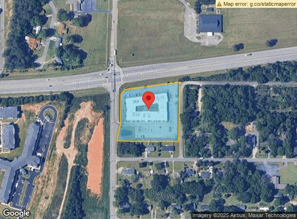
Property Record
691 Wellborn Rd, Warner Robins, GA 31088

NEARBY LISTINGS FOR SALE OR LEASE
Property Detail
691 Wellborn Rd
0W006A040000
Russell Pk 37
Officebuilding
PARCEL A-1 3.407 ACRES 222/5TH
X
Houston
13289C0200B
Georgia
2024
3.41 AC
2024
Perry/Warner Robins
020700
Other Market Areas
29,377 SF
Warner Robins, GA
DEMOGRAPHICS near 691 Wellborn Rd
1 Mile
3 Mile
5 Mile
2024 Total Population
4,094
36,839
89,120
2029 Population
4,534
40,560
97,799
Pop Growth 2024-2029
+ 10.75%
+ 10.10%
+ 9.74%
Average Age
35
37
37
2024 Total Households
1,543
14,342
34,583
HH Growth 2024-2029
+ 10.89%
+ 10.02%
+ 9.56%
Median Household Inc
$43,124
$61,560
$64,398
Avg Household Size
2.60
2.50
2.50
2024 Avg HH Vehicles
2.00
2.00
2.00
Median Home Value
$84,716
$142,821
$157,965
Median Year Built
1982
1979
1985
Nearby Places
- Restaurants
- Banks
- Shops
- Fitness
- Groceries
SALE & LEASE HISTORY
LISTING DATE
SALE/LEASE

Sep 25, 2016
For Lease
May 22, 2017
For Sale
Jun 02, 2023
For Sale
Jul 24, 2019
For Lease
Jan 03, 2022
For Sale
Feb 21, 2018
For Sale
Apr 01, 2022
For Lease
Nearby Properties
Address
Land Use
TOTAL SIZE
Lot Size
Zoning
Address
Land Use
TOTAL SIZE
Lot Size
Zoning
88,965 SF
18.72 AC
R2
Address
Land Use
TOTAL SIZE
Lot Size
Zoning
11,658 SF
30.23 AC
R2
Address
Land Use
TOTAL SIZE
Lot Size
Zoning
10,568 SF
35.44 AC
R4
Address
Land Use
TOTAL SIZE
Lot Size
Zoning
100,320 SF
26.91 AC
C2
Address
Land Use
TOTAL SIZE
Lot Size
Zoning
304,246 SF
23.11 AC
C2
Address
Land Use
TOTAL SIZE
Lot Size
Zoning
178,400 SF
49.03 AC
R2
Address
Land Use
TOTAL SIZE
Lot Size
Zoning
3,199 SF
41.42 AC
R4
Address
Land Use
TOTAL SIZE
Lot Size
Zoning
842,179 SF
101.75 AC
M2
Address
Land Use
TOTAL SIZE
Lot Size
Zoning
210,408 SF
47.18 AC
C2
Address
Land Use
TOTAL SIZE
Lot Size
Zoning
19,200 SF
14.70 AC
R4
Address
Land Use
TOTAL SIZE
Lot Size
Zoning
156,000 SF
19.25 AC
R2
Address
Land Use
TOTAL SIZE
Lot Size
Zoning
17,832 SF
13.60 AC
R4
Address
Land Use
TOTAL SIZE
Lot Size
Zoning
120,000 SF
19.03 AC
R3
Address
Land Use
TOTAL SIZE
Lot Size
Zoning
93,450 SF
11.16 AC
R2
Address
Land Use
TOTAL SIZE
Lot Size
Zoning
60,000 SF
8.95 AC
C3
Address
Land Use
TOTAL SIZE
Lot Size
Zoning
25,062 SF
R4
Address
Land Use
TOTAL SIZE
Lot Size
Zoning
75,400 SF
12.12 AC
R2
Address
Land Use
TOTAL SIZE
Lot Size
Zoning
1,512 SF
309.01 AC
M2
Address
Land Use
TOTAL SIZE
Lot Size
Zoning
71,434 SF
10.58 AC
R2
Address
Land Use
TOTAL SIZE
Lot Size
Zoning
60,120 SF
13.97 AC
R2
Address
Land Use
TOTAL SIZE
Lot Size
Zoning
14,096 SF
14.12 AC
R4
Address
Land Use
TOTAL SIZE
Lot Size
Zoning
75,613 SF
11.51 AC
C1
Address
Land Use
TOTAL SIZE
Lot Size
Zoning
90,000 SF
9.20 AC
R2
Address
Land Use
TOTAL SIZE
Lot Size
Zoning
22,500 SF
9.80 AC
R2
Address
Land Use
TOTAL SIZE
Lot Size
Zoning
5,412 SF
4.98 AC
R4
Address
Land Use
TOTAL SIZE
Lot Size
Zoning
85,000 SF
12.61 AC
R2
Address
Land Use
TOTAL SIZE
Lot Size
Zoning
72,688 SF
9.47 AC
R1
Address
Land Use
TOTAL SIZE
Lot Size
Zoning
102,400 SF
28.22 AC
M2
Address
Land Use
TOTAL SIZE
Lot Size
Zoning
40,000 SF
13.01 AC
C2
Address
Land Use
TOTAL SIZE
Lot Size
Zoning
24,864 SF
9.13 AC
R2
The World's #1 Commercial Real Estate Marketplace
Connect with us
© 2025 CoStar Group
The information above has been obtained from sources believed reliable. While we do not doubt its accuracy we have not verified it and make no guarantee, warranty or representation about it. It is your responsibility to independently confirm its accuracy and completeness. Any projections, opinions, assumptions, or estimates used are for example only and do not represent the current or future performance of the property. The value of this transaction to you depends on tax and other factors which should be evaluated by your tax, financial, and legal advisors. You and your advisors should conduct a careful, independent investigation of the property to determine to your satisfaction the suitability of the property for your needs.