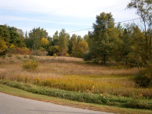
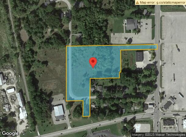
Property Record
6910 S Greenville Rd, Greenville, MI 48838
NEARBY LISTINGS FOR SALE OR LEASE
-
-
View all Greenville listings for sale on LoopNet.com
Property Detail
6910 S Greenville Rd
Other Market Areas
Eureka Court
Grand Rapids-Wyoming, MI
PART OF GOVT LOT 5 SEC 4; DESC AS COM AT THE SE COR OF SD SEC; TH N 0 DEG 00' E 613 FT ALG THE E LINE OF SD SEC TO POB; TH S
052-804-001-00
Montcalm
Commercialnec
Michigan
2024
5
2024
5.21 AC
9712001053
Michigan North Central Area
DEMOGRAPHICS near 6910 S Greenville Rd
1 Mile
3 Mile
5 Mile
2024 Total Population
3,352
13,029
18,216
2029 Population
3,478
13,591
18,998
Pop Growth 2024-2029
+ 3.76%
+ 4.31%
+ 4.29%
Average Age
38
40
41
2024 Total Households
1,331
5,180
7,194
HH Growth 2024-2029
+ 3.61%
+ 4.17%
+ 4.17%
Median Household Inc
$45,833
$50,378
$54,349
Avg Household Size
2.40
2.40
2.40
2024 Avg HH Vehicles
2.00
2.00
2.00
Median Home Value
$132,582
$157,636
$170,845
Median Year Built
1953
1972
1975
Nearby Places
- Restaurants
- Banks
- Shops
- Fitness
- Groceries
PUBLIC TRANSPORTATION
AIRPORT
Gerald R Ford International
DRIVE
WALK
Distance
Gerald R Ford International
61 min
40.4 mi
Freight Ports
Port Milwaukee
DRIVE
WALK
Distance
Port Milwaukee
348 min
296.1 mi
Nearby Properties
Address
Land Use
TOTAL SIZE
Lot Size
Zoning
Address
Land Use
TOTAL SIZE
Lot Size
Zoning
Address
Land Use
TOTAL SIZE
Lot Size
Zoning
Address
Land Use
TOTAL SIZE
Lot Size
Zoning
37.29 AC
R-1
Address
Land Use
TOTAL SIZE
Lot Size
Zoning
10.39 AC
R-1
Address
Land Use
TOTAL SIZE
Lot Size
Zoning
31.05 AC
C-2
Address
Land Use
TOTAL SIZE
Lot Size
Zoning
11.06 AC
Address
Land Use
TOTAL SIZE
Lot Size
Zoning
42.80 AC
IND
Address
Land Use
TOTAL SIZE
Lot Size
Zoning
96.66 AC
IND
Address
Land Use
TOTAL SIZE
Lot Size
Zoning
11.90 AC
C-2
Address
Land Use
TOTAL SIZE
Lot Size
Zoning
7.57 AC
IND
Address
Land Use
TOTAL SIZE
Lot Size
Zoning
1.65 AC
Address
Land Use
TOTAL SIZE
Lot Size
Zoning
7.88 AC
C-2
Address
Land Use
TOTAL SIZE
Lot Size
Zoning
5.64 AC
IND
Address
Land Use
TOTAL SIZE
Lot Size
Zoning
11.61 AC
Address
Land Use
TOTAL SIZE
Lot Size
Zoning
Address
Land Use
TOTAL SIZE
Lot Size
Zoning
6.03 AC
IND
Address
Land Use
TOTAL SIZE
Lot Size
Zoning
2.40 AC
IND
Address
Land Use
TOTAL SIZE
Lot Size
Zoning
13.45 AC
PC
Address
Land Use
TOTAL SIZE
Lot Size
Zoning
4.66 AC
Address
Land Use
TOTAL SIZE
Lot Size
Zoning
3.42 AC
C-2
Address
Land Use
TOTAL SIZE
Lot Size
Zoning
9.61 AC
IND
Address
Land Use
TOTAL SIZE
Lot Size
Zoning
6.09 AC
IND
Address
Land Use
TOTAL SIZE
Lot Size
Zoning
Address
Land Use
TOTAL SIZE
Lot Size
Zoning
4.46 AC
IND
Address
Land Use
TOTAL SIZE
Lot Size
Zoning
4.95 AC
OSC-2
Address
Land Use
TOTAL SIZE
Lot Size
Zoning
2.78 AC
C-2
Address
Land Use
TOTAL SIZE
Lot Size
Zoning
11.50 AC
R-3
Address
Land Use
TOTAL SIZE
Lot Size
Zoning
4.88 AC
Address
Land Use
TOTAL SIZE
Lot Size
Zoning
2.86 AC
C-2
Address
Land Use
TOTAL SIZE
Lot Size
Zoning
The World's #1 Commercial Real Estate Marketplace
Connect with us
© 2025 CoStar Group
The information above has been obtained from sources believed reliable. While we do not doubt its accuracy we have not verified it and make no guarantee, warranty or representation about it. It is your responsibility to independently confirm its accuracy and completeness. Any projections, opinions, assumptions, or estimates used are for example only and do not represent the current or future performance of the property. The value of this transaction to you depends on tax and other factors which should be evaluated by your tax, financial, and legal advisors. You and your advisors should conduct a careful, independent investigation of the property to determine to your satisfaction the suitability of the property for your needs.