Property Record
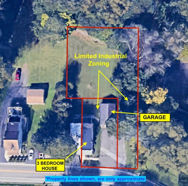
692 Lenni Rd, Aston, PA 19014
NEARBY LISTINGS FOR SALE OR LEASE
-
-
View all Aston listings for sale on LoopNet.com
Property Detail
692 Lenni Rd
06-00-00038-00
George Pincin
Duplex
GRD .38AC
X
Delaware
42045C0089F
Pennsylvania
2024
0.11 AC
2025
Delaware County
407000
Philadelphia
2,226 SF
Philadelphia-Camden-Wilmington, PA-NJ-DE-MD
DEMOGRAPHICS near 692 Lenni Rd
1 Mile
3 Mile
5 Mile
2024 Total Population
3,574
42,531
146,291
2029 Population
3,542
41,959
145,174
Pop Growth 2024-2029
(0.90%)
(1.34%)
(0.76%)
Average Age
41
44
43
2024 Total Households
1,286
15,719
57,079
HH Growth 2024-2029
(1.01%)
(1.52%)
(0.87%)
Median Household Inc
$110,188
$105,007
$92,271
Avg Household Size
2.60
2.50
2.50
2024 Avg HH Vehicles
2.00
2.00
2.00
Median Home Value
$318,134
$374,191
$346,117
Median Year Built
1978
1975
1970
Nearby Places
Map Layers
Map Styles
 Street
 Aerial
- Restaurants
- Banks
- Shops
- Fitness
- Groceries
PUBLIC TRANSPORTATION
COMMUTER RAIL
Elwyn (R3 - Southeastern Pennsylvania Transportation Authority Regional Rail (SEPTA Regional Rail))
DRIVE
WALK
Distance
Elwyn (R3 - Southeastern Pennsylvania Transportation Authority Regional Rail (SEPTA Regional Rail))
7 min
2.8 mi
Wawa (Media/Wawa Line - SEPTA)
DRIVE
WALK
Distance
Wawa (Media/Wawa Line - SEPTA)
6 min
3.4 mi
AIRPORT
Philadelphia International
DRIVE
WALK
Distance
Philadelphia International
26 min
13.7 mi
Freight Ports
Port of Wilmington, RI
DRIVE
WALK
Distance
Port of Wilmington, RI
27 min
17.3 mi
SALE & LEASE HISTORY
LISTING DATE
SALE/LEASE

Jul 11, 2024
For Sale
Nearby Properties
Address
Land Use
TOTAL SIZE
Lot Size
Zoning
Address
Land Use
TOTAL SIZE
Lot Size
Zoning
86,400 SF
75 AC
Address
Land Use
TOTAL SIZE
Lot Size
Zoning
51,394 SF
198.04 AC
Address
Land Use
TOTAL SIZE
Lot Size
Zoning
108,030 SF
26.10 AC
Address
Land Use
TOTAL SIZE
Lot Size
Zoning
9,554 SF
69.96 AC
Address
Land Use
TOTAL SIZE
Lot Size
Zoning
38.39 AC
Address
Land Use
TOTAL SIZE
Lot Size
Zoning
2,226 SF
25.25 AC
Address
Land Use
TOTAL SIZE
Lot Size
Zoning
1,596 SF
21.92 AC
Address
Land Use
TOTAL SIZE
Lot Size
Zoning
62,832 SF
39.05 AC
Address
Land Use
TOTAL SIZE
Lot Size
Zoning
111,606 SF
50 AC
Address
Land Use
TOTAL SIZE
Lot Size
Zoning
36.50 AC
Address
Land Use
TOTAL SIZE
Lot Size
Zoning
137,640 SF
3.67 AC
Address
Land Use
TOTAL SIZE
Lot Size
Zoning
268 AC
Address
Land Use
TOTAL SIZE
Lot Size
Zoning
241,250 SF
2 AC
Address
Land Use
TOTAL SIZE
Lot Size
Zoning
44,759 SF
5 AC
Address
Land Use
TOTAL SIZE
Lot Size
Zoning
61,536 SF
44 AC
Address
Land Use
TOTAL SIZE
Lot Size
Zoning
151,153 SF
242.50 AC
Address
Land Use
TOTAL SIZE
Lot Size
Zoning
66,200 SF
Address
Land Use
TOTAL SIZE
Lot Size
Zoning
208,352 SF
21 AC
Address
Land Use
TOTAL SIZE
Lot Size
Zoning
4,800 SF
27 AC
Address
Land Use
TOTAL SIZE
Lot Size
Zoning
104,220 SF
36.89 AC
Address
Land Use
TOTAL SIZE
Lot Size
Zoning
53,187 SF
217.32 AC
Address
Land Use
TOTAL SIZE
Lot Size
Zoning
51,100 SF
54.10 AC
Address
Land Use
TOTAL SIZE
Lot Size
Zoning
24,240 SF
10.58 AC
Address
Land Use
TOTAL SIZE
Lot Size
Zoning
19,344 SF
11 AC
Address
Land Use
TOTAL SIZE
Lot Size
Zoning
71,365 SF
11.13 AC
Address
Land Use
TOTAL SIZE
Lot Size
Zoning
2,364 SF
5.39 AC
Address
Land Use
TOTAL SIZE
Lot Size
Zoning
23,976 SF
7.89 AC
Address
Land Use
TOTAL SIZE
Lot Size
Zoning
1,204 SF
7.39 AC
Address
Land Use
TOTAL SIZE
Lot Size
Zoning
48,965 SF
36.89 AC
Address
Land Use
TOTAL SIZE
Lot Size
Zoning
56,167 SF
4.95 AC
The World's #1 Commercial Real Estate Marketplace
Connect with us
© 2025 CoStar Group
The information above has been obtained from sources believed reliable. While we do not doubt its accuracy we have not verified it and make no guarantee, warranty or representation about it. It is your responsibility to independently confirm its accuracy and completeness. Any projections, opinions, assumptions, or estimates used are for example only and do not represent the current or future performance of the property. The value of this transaction to you depends on tax and other factors which should be evaluated by your tax, financial, and legal advisors. You and your advisors should conduct a careful, independent investigation of the property to determine to your satisfaction the suitability of the property for your needs.