Property Record
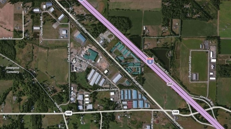
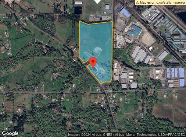
6950 Vista Dr, Ferndale, WA 98248
NEARBY LISTINGS FOR SALE OR LEASE
Property Detail
6950 Vista Dr
390101-476140-0000
THAT PTN OF E 1/2 SE LY NELY OF BLAINE FERNDALE RD (VISTA DR-CO RD 42)-EXC PTN DAF-BEG AT SE SEC COR-TH W ALG S SEC LI 204.5 FT-TH N 38 DEG 2700 W 1100 FT TAP ON C/L OF CO RD 42-TPOB-TH N 38 DEG 2700 W ALG SD C/L 142.5 FT-TH N 54 DEG 0900 E 209.6 FT-
Ranch
Whatcom
X
Washington
53073C0690D
43.79 AC
2024
Bellingham/Northwest
2023
Other Market Areas
010404
Bellingham, WA
3,332 SF
DEMOGRAPHICS near 6950 Vista Dr
1 Mile
3 Mile
5 Mile
2024 Total Population
616
14,151
26,517
2029 Population
638
14,776
27,581
Pop Growth 2024-2029
+ 3.57%
+ 4.42%
+ 4.01%
Average Age
42
39
40
2024 Total Households
226
4,867
9,341
HH Growth 2024-2029
+ 3.54%
+ 4.36%
+ 3.91%
Median Household Inc
$105,208
$90,215
$92,122
Avg Household Size
2.70
2.90
2.80
2024 Avg HH Vehicles
3.00
3.00
3.00
Median Home Value
$623,983
$524,168
$548,454
Median Year Built
1978
1989
1989
Nearby Places
- Restaurants
- Banks
- Shops
- Fitness
- Groceries
PUBLIC TRANSPORTATION
AIRPORT
Bellingham International
Drive
Walk
Distance
Bellingham International
14 min
10.4 mi
Abbotsford International
Drive
Walk
Distance
Abbotsford International
43 min
23.1 mi
Freight Ports
Port of Bellingham, WA
Drive
Walk
Distance
Port of Bellingham, WA
19 min
13.4 mi
SALE & LEASE HISTORY
LISTING DATE
SALE/LEASE

Jan 31, 2017
For Sale
Nearby Properties
Address
Land Use
TOTAL SIZE
Lot Size
Zoning
Address
Land Use
TOTAL SIZE
Lot Size
Zoning
116159
24.54 AC
P
Address
Land Use
TOTAL SIZE
Lot Size
Zoning
203305
13.80 AC
LII
Address
Land Use
TOTAL SIZE
Lot Size
Zoning
64509
4.40 AC
GB
Address
Land Use
TOTAL SIZE
Lot Size
Zoning
153557
39.70 AC
PBI
Address
Land Use
TOTAL SIZE
Lot Size
Zoning
60446
4.03 AC
PBI
Address
Land Use
TOTAL SIZE
Lot Size
Zoning
72720
3.94 AC
LII
Address
Land Use
TOTAL SIZE
Lot Size
Zoning
103600
7 AC
LII
Address
Land Use
TOTAL SIZE
Lot Size
Zoning
109540
5.30 AC
LII
Address
Land Use
TOTAL SIZE
Lot Size
Zoning
140381
9.76 AC
M
Address
Land Use
TOTAL SIZE
Lot Size
Zoning
23499
4.46 AC
MCD
Address
Land Use
TOTAL SIZE
Lot Size
Zoning
56084
2.75 AC
LI
Address
Land Use
TOTAL SIZE
Lot Size
Zoning
52100
4.07 AC
GB
Address
Land Use
TOTAL SIZE
Lot Size
Zoning
505.89 AC
HII
Address
Land Use
TOTAL SIZE
Lot Size
Zoning
115975
9.21 AC
LII
Address
Land Use
TOTAL SIZE
Lot Size
Zoning
25854
4.94 AC
RS8.5
Address
Land Use
TOTAL SIZE
Lot Size
Zoning
43890
6.90 AC
LII
Address
Land Use
TOTAL SIZE
Lot Size
Zoning
39.72 AC
M
Address
Land Use
TOTAL SIZE
Lot Size
Zoning
1788
19.60 AC
R5A
Address
Land Use
TOTAL SIZE
Lot Size
Zoning
59038
5.57 AC
LII
Address
Land Use
TOTAL SIZE
Lot Size
Zoning
2448
62.11 AC
R5A
Address
Land Use
TOTAL SIZE
Lot Size
Zoning
87004
7 AC
LII
Address
Land Use
TOTAL SIZE
Lot Size
Zoning
1051
21.84 AC
GB
Address
Land Use
TOTAL SIZE
Lot Size
Zoning
25380
2.89 AC
LII
Address
Land Use
TOTAL SIZE
Lot Size
Zoning
27500
2.42 AC
LI
Address
Land Use
TOTAL SIZE
Lot Size
Zoning
45883
3.10 AC
LII
Address
Land Use
TOTAL SIZE
Lot Size
Zoning
26681
73 AC
AG
Address
Land Use
TOTAL SIZE
Lot Size
Zoning
7.48 AC
GB
Address
Land Use
TOTAL SIZE
Lot Size
Zoning
11206
3.77 AC
GB
Address
Land Use
TOTAL SIZE
Lot Size
Zoning
27796
5.38 AC
LII
Address
Land Use
TOTAL SIZE
Lot Size
Zoning
30600
2.06 AC
LII
Start a new search to find other properties for sale or lease
Connect with us
© 2024 CoStar Group
The information above has been obtained from sources believed reliable. While we do not doubt its accuracy we have not verified it and make no guarantee, warranty or representation about it. It is your responsibility to independently confirm its accuracy and completeness. Any projections, opinions, assumptions, or estimates used are for example only and do not represent the current or future performance of the property. The value of this transaction to you depends on tax and other factors which should be evaluated by your tax, financial, and legal advisors. You and your advisors should conduct a careful, independent investigation of the property to determine to your satisfaction the suitability of the property for your needs.