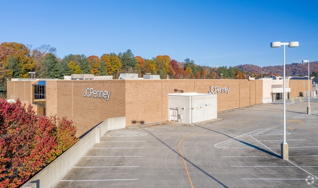
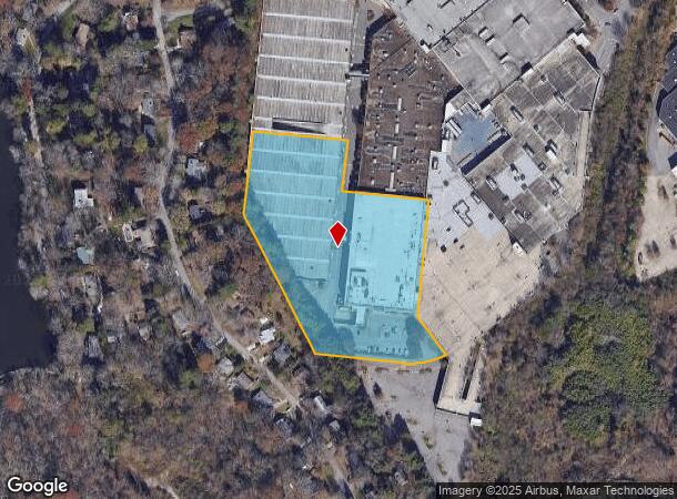
Property Record
7 S Tunnel Rd, Asheville, NC 28805

This Property Is For Sale
NEARBY LISTINGS FOR SALE OR LEASE
Property Detail
7 S Tunnel Rd
9658-14-3261-00000
Kenilworh Forest
Regionalshoppingcenterormallwithanchorstore
PLAT: 0000-0000
X
Buncombe
3700965800J
North Carolina
2024
6.24 AC
2025
Central Asheville
001802
Asheville
67,092 SF
Asheville, NC
DEMOGRAPHICS near 7 S Tunnel Rd
1 Mile
3 Mile
5 Mile
2024 Total Population
6,673
47,025
94,976
2029 Population
6,905
48,784
98,380
Pop Growth 2024-2029
+ 3.48%
+ 3.74%
+ 3.58%
Average Age
42
42
42
2024 Total Households
3,329
22,113
43,127
HH Growth 2024-2029
+ 3.00%
+ 3.34%
+ 3.10%
Median Household Inc
$55,941
$59,843
$64,964
Avg Household Size
1.90
2.00
2.10
2024 Avg HH Vehicles
1.00
2.00
2.00
Median Home Value
$345,406
$364,762
$380,106
Median Year Built
1978
1975
1978
Nearby Places
Map Layers
Map Styles
 Street
 Aerial
- Restaurants
- Banks
- Shops
- Fitness
- Groceries
PUBLIC TRANSPORTATION
AIRPORT
Asheville Regional
DRIVE
WALK
Distance
Asheville Regional
26 min
13.7 mi
Freight Ports
North Charleston Terminal
DRIVE
WALK
Distance
North Charleston Terminal
298 min
257.4 mi
Nearby Properties
Address
Land Use
TOTAL SIZE
Lot Size
Zoning
Address
Land Use
TOTAL SIZE
Lot Size
Zoning
1,663,129 SF
27.85 AC
INST
Address
Land Use
TOTAL SIZE
Lot Size
Zoning
426,749 SF
2,485.30 AC
CS
Address
Land Use
TOTAL SIZE
Lot Size
Zoning
496,200 SF
109.28 AC
INST
Address
Land Use
TOTAL SIZE
Lot Size
Zoning
40,152 SF
2.78 AC
CBD
Address
Land Use
TOTAL SIZE
Lot Size
Zoning
31,034 SF
1.12 AC
CBD
Address
Land Use
TOTAL SIZE
Lot Size
Zoning
94,776 SF
39.70 AC
INST
Address
Land Use
TOTAL SIZE
Lot Size
Zoning
94,004 SF
2.74 AC
CBD
Address
Land Use
TOTAL SIZE
Lot Size
Zoning
109,294 SF
16.28 AC
RAD-IND
Address
Land Use
TOTAL SIZE
Lot Size
Zoning
118,000 SF
0.17 AC
CBD
Address
Land Use
TOTAL SIZE
Lot Size
Zoning
125,122 SF
13.63 AC
UP
Address
Land Use
TOTAL SIZE
Lot Size
Zoning
81,765 SF
23.53 AC
HB
Address
Land Use
TOTAL SIZE
Lot Size
Zoning
47,344 SF
0.71 AC
CBD
Address
Land Use
TOTAL SIZE
Lot Size
Zoning
170,226 SF
29.47 AC
INST
Address
Land Use
TOTAL SIZE
Lot Size
Zoning
51,476 SF
5.82 AC
CBD
Address
Land Use
TOTAL SIZE
Lot Size
Zoning
78,563 SF
2.88 AC
UP
Address
Land Use
TOTAL SIZE
Lot Size
Zoning
20,352 SF
0.67 AC
CBD
Address
Land Use
TOTAL SIZE
Lot Size
Zoning
426,688 SF
40.88 AC
UP
Address
Land Use
TOTAL SIZE
Lot Size
Zoning
50,248 SF
12.87 AC
INST
Address
Land Use
TOTAL SIZE
Lot Size
Zoning
47,729 SF
5.50 AC
CBD
Address
Land Use
TOTAL SIZE
Lot Size
Zoning
79,701 SF
15.26 AC
RM16
Address
Land Use
TOTAL SIZE
Lot Size
Zoning
75,342 SF
8.07 AC
HB
Address
Land Use
TOTAL SIZE
Lot Size
Zoning
52,336 SF
2.05 AC
CBD
Address
Land Use
TOTAL SIZE
Lot Size
Zoning
40,900 SF
13.77 AC
R-5
Address
Land Use
TOTAL SIZE
Lot Size
Zoning
59,200 SF
33.49 AC
R-1
Address
Land Use
TOTAL SIZE
Lot Size
Zoning
18,444 SF
0.66 AC
CBD
Address
Land Use
TOTAL SIZE
Lot Size
Zoning
69,472 SF
0.99 AC
CBD
Address
Land Use
TOTAL SIZE
Lot Size
Zoning
30,000 SF
8.25 AC
INST
Address
Land Use
TOTAL SIZE
Lot Size
Zoning
150,650 SF
18.31 AC
IND
Address
Land Use
TOTAL SIZE
Lot Size
Zoning
114,700 SF
8.91 AC
RM16
Address
Land Use
TOTAL SIZE
Lot Size
Zoning
80,319 SF
CBD
The World's #1 Commercial Real Estate Marketplace
Connect with us
© 2026 CoStar Group
The information above has been obtained from sources believed reliable. While we do not doubt its accuracy we have not verified it and make no guarantee, warranty or representation about it. It is your responsibility to independently confirm its accuracy and completeness. Any projections, opinions, assumptions, or estimates used are for example only and do not represent the current or future performance of the property. The value of this transaction to you depends on tax and other factors which should be evaluated by your tax, financial, and legal advisors. You and your advisors should conduct a careful, independent investigation of the property to determine to your satisfaction the suitability of the property for your needs.