Property Record
702 N Main St, Robersonville, NC 27871

NEARBY LISTINGS FOR SALE OR LEASE
-
-
View all Robersonville listings for lease on LoopNet.com
Property Detail
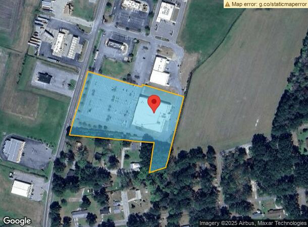
702 N Main St
Supermarket
FOOD LION 702 N MAIN
X
Martin
3720570600J
North Carolina
2024
5.64 AC
2024
Other Market Areas
970600
0703187
32,294 SF
DEMOGRAPHICS near 702 N Main St
1 Mile
3 Mile
5 Mile
2024 Total Population
701
1,588
2,792
2029 Population
633
1,441
2,574
Pop Growth 2024-2029
(9.70%)
(9.26%)
(7.81%)
Average Age
46
45
45
2024 Total Households
308
691
1,199
HH Growth 2024-2029
(9.42%)
(9.12%)
(7.76%)
Median Household Inc
$33,610
$34,780
$38,226
Avg Household Size
2.30
2.30
2.30
2024 Avg HH Vehicles
2.00
2.00
2.00
Median Home Value
$83,897
$83,518
$80,160
Median Year Built
1971
1971
1972
Nearby Places
- Restaurants
- Banks
- Shops
- Fitness
- Groceries
PUBLIC TRANSPORTATION
AIRPORT
Pitt-Greenville
DRIVE
WALK
Distance
Pitt-Greenville
31 min
19.7 mi
Freight Ports
Port of Morehead City
DRIVE
WALK
Distance
Port of Morehead City
146 min
101.8 mi
SALE & LEASE HISTORY
LISTING DATE
SALE/LEASE

May 09, 2017
For Lease
Nearby Properties
Address
Land Use
TOTAL SIZE
Lot Size
Zoning
Address
Land Use
TOTAL SIZE
Lot Size
Zoning
48,892 SF
17.42 AC
Address
Land Use
TOTAL SIZE
Lot Size
Zoning
49,168 SF
21.77 AC
C
Address
Land Use
TOTAL SIZE
Lot Size
Zoning
Address
Land Use
TOTAL SIZE
Lot Size
Zoning
1.79 AC
Address
Land Use
TOTAL SIZE
Lot Size
Zoning
206,369 SF
12.98 AC
OI
Address
Land Use
TOTAL SIZE
Lot Size
Zoning
19,188 SF
51.14 AC
C
Address
Land Use
TOTAL SIZE
Lot Size
Zoning
146,164 SF
30.20 AC
Address
Land Use
TOTAL SIZE
Lot Size
Zoning
13,634 SF
19.34 AC
A
Address
Land Use
TOTAL SIZE
Lot Size
Zoning
10,126 SF
7.36 AC
R15
Address
Land Use
TOTAL SIZE
Lot Size
Zoning
3,991 SF
1.86 AC
Address
Land Use
TOTAL SIZE
Lot Size
Zoning
3,516 SF
3.23 AC
Address
Land Use
TOTAL SIZE
Lot Size
Zoning
1.79 AC
CD
Address
Land Use
TOTAL SIZE
Lot Size
Zoning
3,404 SF
1.33 AC
Address
Land Use
TOTAL SIZE
Lot Size
Zoning
80,400 SF
17.55 AC
I
Address
Land Use
TOTAL SIZE
Lot Size
Zoning
3,144 SF
0.86 AC
CB
Address
Land Use
TOTAL SIZE
Lot Size
Zoning
11,520 SF
4.27 AC
C
Address
Land Use
TOTAL SIZE
Lot Size
Zoning
4,375 SF
3.02 AC
C
Address
Land Use
TOTAL SIZE
Lot Size
Zoning
1.60 AC
Address
Land Use
TOTAL SIZE
Lot Size
Zoning
272.10 AC
R
Address
Land Use
TOTAL SIZE
Lot Size
Zoning
223.27 AC
A
Address
Land Use
TOTAL SIZE
Lot Size
Zoning
4,480 SF
13.30 AC
C
Address
Land Use
TOTAL SIZE
Lot Size
Zoning
64,509 SF
11.13 AC
M1
Address
Land Use
TOTAL SIZE
Lot Size
Zoning
339.87 AC
A
Address
Land Use
TOTAL SIZE
Lot Size
Zoning
2,924 SF
1.70 AC
Address
Land Use
TOTAL SIZE
Lot Size
Zoning
0.17 AC
Address
Land Use
TOTAL SIZE
Lot Size
Zoning
2,212 SF
214.92 AC
A
Address
Land Use
TOTAL SIZE
Lot Size
Zoning
8,419 SF
0.86 AC
CB
Address
Land Use
TOTAL SIZE
Lot Size
Zoning
115.08 AC
A
Address
Land Use
TOTAL SIZE
Lot Size
Zoning
101.99 AC
A
The World's #1 Commercial Real Estate Marketplace
Connect with us
© 2025 CoStar Group
The information above has been obtained from sources believed reliable. While we do not doubt its accuracy we have not verified it and make no guarantee, warranty or representation about it. It is your responsibility to independently confirm its accuracy and completeness. Any projections, opinions, assumptions, or estimates used are for example only and do not represent the current or future performance of the property. The value of this transaction to you depends on tax and other factors which should be evaluated by your tax, financial, and legal advisors. You and your advisors should conduct a careful, independent investigation of the property to determine to your satisfaction the suitability of the property for your needs.