Property Record
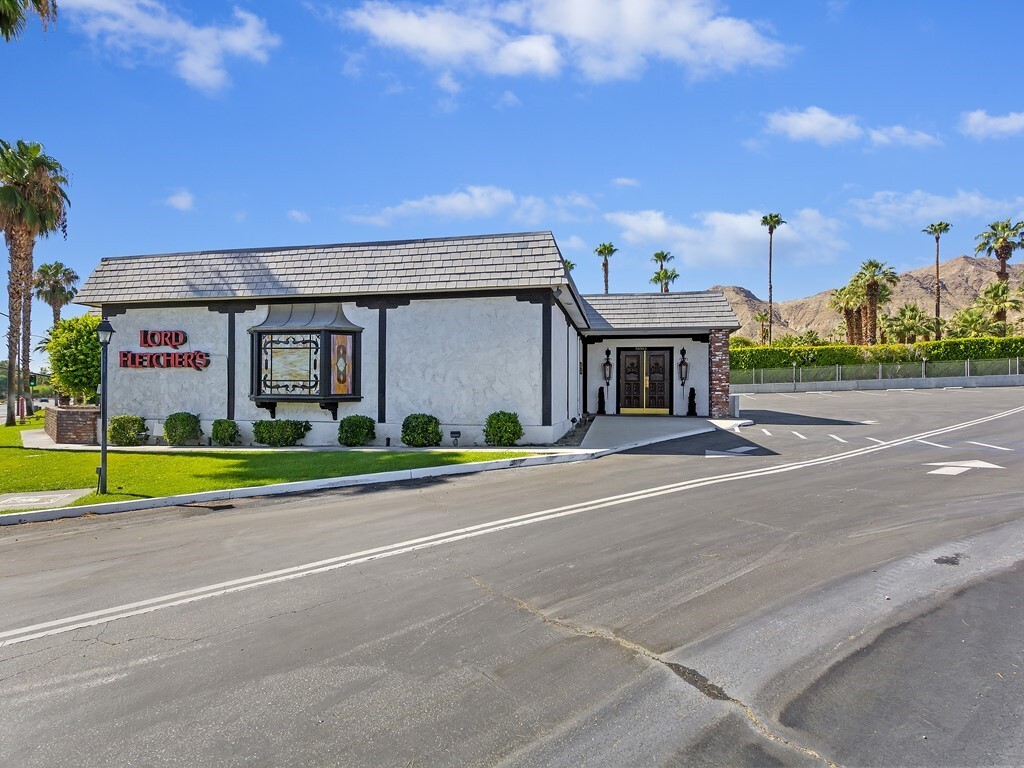
70385 Highway 111, Rancho Mirage, CA 92270


NEARBY LISTINGS FOR SALE OR LEASE
Property Detail
70385 Highway 111
689-210-022
.69 ACRES M/L IN POR SW 1/4 OF SEC 2 T5S R5E FOR TOTAL DESCRIPTION SEE ASSESSORS MAPS
Restaurantbuilding
Riverside
X
California
06065C1595G
0.69 AC
2023
Coachella Valley
2023
Inland Empire (California)
045103
Riverside-San Bernardino-Ontario, CA
3,944 SF
DEMOGRAPHICS near 70385 Highway 111
1 Mile
3 Mile
5 Mile
2024 Total Population
3,803
36,884
119,806
2029 Population
4,279
40,806
131,651
Pop Growth 2024-2029
+ 12.52%
+ 10.63%
+ 9.89%
Average Age
58
57
51
2024 Total Households
2,005
18,578
54,507
HH Growth 2024-2029
+ 12.32%
+ 10.42%
+ 10.16%
Median Household Inc
$84,878
$78,947
$68,924
Avg Household Size
1.80
1.90
2.10
2024 Avg HH Vehicles
2.00
2.00
2.00
Median Home Value
$624,830
$610,777
$560,544
Median Year Built
1981
1983
1985
Nearby Places
- Restaurants
- Banks
- Shops
- Fitness
- Groceries
PUBLIC TRANSPORTATION
AIRPORT
Palm Springs International
DRIVE
WALK
Distance
Palm Springs International
14 min
7.8 mi
Freight Ports
Port of San Diego
DRIVE
WALK
Distance
Port of San Diego
166 min
135.6 mi
SALE & LEASE HISTORY
LISTING DATE
SALE/LEASE

Sep 14, 2021
For Sale
Mar 27, 2024
For Lease
Mar 27, 2024
For Sale
Jul 27, 2020
For Sale
Jan 17, 2023
For Lease
Aug 01, 2019
For Sale
Nearby Properties
Address
Land Use
TOTAL SIZE
Lot Size
Zoning
Address
Land Use
TOTAL SIZE
Lot Size
Zoning
488,725 SF
24.17 AC
C1
Address
Land Use
TOTAL SIZE
Lot Size
Zoning
445,569 SF
17.55 AC
PUDC
Address
Land Use
TOTAL SIZE
Lot Size
Zoning
68.20 AC
Address
Land Use
TOTAL SIZE
Lot Size
Zoning
15,606 SF
162.93 AC
Address
Land Use
TOTAL SIZE
Lot Size
Zoning
217,730 SF
8.64 AC
R1010
Address
Land Use
TOTAL SIZE
Lot Size
Zoning
168,038 SF
6 AC
Address
Land Use
TOTAL SIZE
Lot Size
Zoning
103,940 SF
4.56 AC
Address
Land Use
TOTAL SIZE
Lot Size
Zoning
179,685 SF
9.36 AC
Address
Land Use
TOTAL SIZE
Lot Size
Zoning
Address
Land Use
TOTAL SIZE
Lot Size
Zoning
137,962 SF
8.90 AC
Address
Land Use
TOTAL SIZE
Lot Size
Zoning
208,000 SF
16.04 AC
Address
Land Use
TOTAL SIZE
Lot Size
Zoning
136,875 SF
8.87 AC
O
Address
Land Use
TOTAL SIZE
Lot Size
Zoning
58,823 SF
5.87 AC
C-N
Address
Land Use
TOTAL SIZE
Lot Size
Zoning
122,738 SF
16.13 AC
R1
Address
Land Use
TOTAL SIZE
Lot Size
Zoning
44,823 SF
12.07 AC
CG
Address
Land Use
TOTAL SIZE
Lot Size
Zoning
Address
Land Use
TOTAL SIZE
Lot Size
Zoning
66,156 SF
5.85 AC
Address
Land Use
TOTAL SIZE
Lot Size
Zoning
36,514 SF
2.10 AC
PUDA
Address
Land Use
TOTAL SIZE
Lot Size
Zoning
43,127 SF
65.36 AC
Address
Land Use
TOTAL SIZE
Lot Size
Zoning
92,722 SF
5.55 AC
O
Address
Land Use
TOTAL SIZE
Lot Size
Zoning
32,158 SF
1.96 AC
PUDLC
Address
Land Use
TOTAL SIZE
Lot Size
Zoning
66,732 SF
1.80 AC
PCC
Address
Land Use
TOTAL SIZE
Lot Size
Zoning
71,665 SF
3.31 AC
CN
Address
Land Use
TOTAL SIZE
Lot Size
Zoning
6,717 SF
17.79 AC
Address
Land Use
TOTAL SIZE
Lot Size
Zoning
78,310 SF
6.25 AC
PC3
Address
Land Use
TOTAL SIZE
Lot Size
Zoning
49,980 SF
4.29 AC
Address
Land Use
TOTAL SIZE
Lot Size
Zoning
5.15 AC
CG
Address
Land Use
TOTAL SIZE
Lot Size
Zoning
33,330 SF
4.50 AC
Address
Land Use
TOTAL SIZE
Lot Size
Zoning
32,333 SF
2.80 AC
C-N
Address
Land Use
TOTAL SIZE
Lot Size
Zoning
45,515 SF
1.52 AC
PC4SP
The World's #1 Commercial Real Estate Marketplace
Connect with us
© 2025 CoStar Group
The information above has been obtained from sources believed reliable. While we do not doubt its accuracy we have not verified it and make no guarantee, warranty or representation about it. It is your responsibility to independently confirm its accuracy and completeness. Any projections, opinions, assumptions, or estimates used are for example only and do not represent the current or future performance of the property. The value of this transaction to you depends on tax and other factors which should be evaluated by your tax, financial, and legal advisors. You and your advisors should conduct a careful, independent investigation of the property to determine to your satisfaction the suitability of the property for your needs.