Property Record
7048 Zion Church Rd Ne, Leland, NC 28451
NEARBY LISTINGS FOR SALE OR LEASE
-
-
View all Leland listings for sale on LoopNet.com
Property Detail
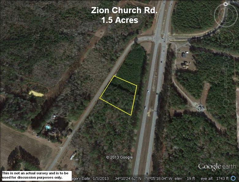
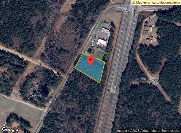
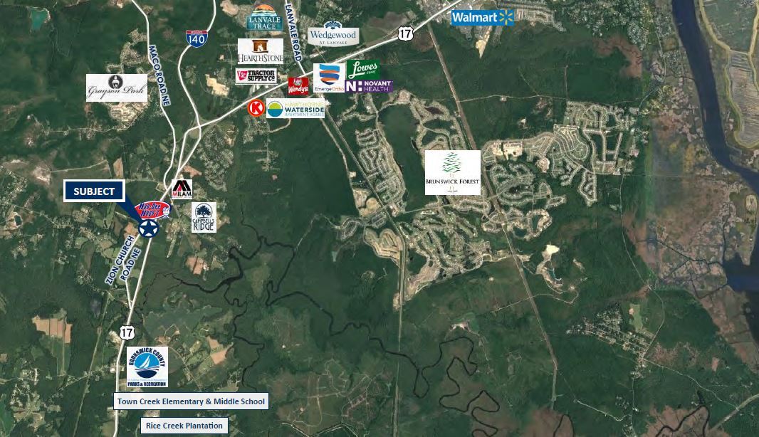
7048 Zion Church Rd Ne
Myrtle Beach-Conway-North Myrtle Beach, SC-NC
Nature Park
0700004834
TR-B 1.38 ACRES PLAT 46/41 US 17 & SR 1701
Vacantlandnec
Brunswick
X
North Carolina
3720217500K
1.38 AC
2023
Leland
2024
Wilmington
020203
DEMOGRAPHICS near 7048 Zion Church Rd Ne
1 Mile
3 Mile
5 Mile
2024 Total Population
833
7,431
19,786
2029 Population
1,103
9,689
25,636
Pop Growth 2024-2029
+ 32.41%
+ 30.39%
+ 29.57%
Average Age
41
44
47
2024 Total Households
325
3,034
8,350
HH Growth 2024-2029
+ 32.31%
+ 30.22%
+ 29.39%
Median Household Inc
$64,687
$67,171
$73,632
Avg Household Size
2.50
2.40
2.30
2024 Avg HH Vehicles
2.00
2.00
2.00
Median Home Value
$190,864
$235,590
$290,184
Median Year Built
2008
2008
2007
Nearby Places
- Restaurants
- Banks
- Shops
- Fitness
- Groceries
PUBLIC TRANSPORTATION
AIRPORT
Wilmington International
DRIVE
WALK
Distance
Wilmington International
30 min
17.0 mi
Freight Ports
Port of Wilmington
DRIVE
WALK
Distance
Port of Wilmington
20 min
12.7 mi
SALE & LEASE HISTORY
LISTING DATE
SALE/LEASE

Sep 24, 2016
For Sale
Jul 15, 2022
For Sale
Apr 27, 2018
For Sale
Nearby Properties
Address
Land Use
TOTAL SIZE
Lot Size
Zoning
Address
Land Use
TOTAL SIZE
Lot Size
Zoning
6,839 SF
28.63 AC
MF
Address
Land Use
TOTAL SIZE
Lot Size
Zoning
91,140 SF
60.72 AC
R75
Address
Land Use
TOTAL SIZE
Lot Size
Zoning
54,900 SF
3.55 AC
C2
Address
Land Use
TOTAL SIZE
Lot Size
Zoning
43,792 SF
2.58 AC
C2
Address
Land Use
TOTAL SIZE
Lot Size
Zoning
1,652 SF
20.64 AC
CLD
Address
Land Use
TOTAL SIZE
Lot Size
Zoning
34,070 SF
11.09 AC
C2
Address
Land Use
TOTAL SIZE
Lot Size
Zoning
18,750 SF
3.39 AC
C1
Address
Land Use
TOTAL SIZE
Lot Size
Zoning
14,800 SF
3.84 AC
CLD
Address
Land Use
TOTAL SIZE
Lot Size
Zoning
30,016 SF
2.50 AC
PUD
Address
Land Use
TOTAL SIZE
Lot Size
Zoning
16,040 SF
21.21 AC
PUD
Address
Land Use
TOTAL SIZE
Lot Size
Zoning
3,912 SF
45.03 AC
CP
Address
Land Use
TOTAL SIZE
Lot Size
Zoning
10,218 SF
0.87 AC
C2
Address
Land Use
TOTAL SIZE
Lot Size
Zoning
4,400 SF
2.90 AC
CLD
Address
Land Use
TOTAL SIZE
Lot Size
Zoning
4,524 SF
1.26 AC
C2
Address
Land Use
TOTAL SIZE
Lot Size
Zoning
19,418 SF
2.48 AC
PUD
Address
Land Use
TOTAL SIZE
Lot Size
Zoning
5,478 SF
2.48 AC
PUD
Address
Land Use
TOTAL SIZE
Lot Size
Zoning
3,486 SF
1.95 AC
CLD
Address
Land Use
TOTAL SIZE
Lot Size
Zoning
6,107 SF
3.96 AC
CLD
Address
Land Use
TOTAL SIZE
Lot Size
Zoning
37.72 AC
PUD
Address
Land Use
TOTAL SIZE
Lot Size
Zoning
4,432 SF
0.61 AC
C2
Address
Land Use
TOTAL SIZE
Lot Size
Zoning
5,602 SF
5.71 AC
OI
Address
Land Use
TOTAL SIZE
Lot Size
Zoning
5,009 SF
8.27 AC
CLD
Address
Land Use
TOTAL SIZE
Lot Size
Zoning
4,275 SF
4.30 AC
CLD
Address
Land Use
TOTAL SIZE
Lot Size
Zoning
10,961 SF
1.94 AC
RR
Address
Land Use
TOTAL SIZE
Lot Size
Zoning
5,298 SF
4.21 AC
CLD
Address
Land Use
TOTAL SIZE
Lot Size
Zoning
3,000 SF
0.10 AC
CLD
Address
Land Use
TOTAL SIZE
Lot Size
Zoning
325.44 AC
RR
Address
Land Use
TOTAL SIZE
Lot Size
Zoning
5,459 SF
2.58 AC
CI
Address
Land Use
TOTAL SIZE
Lot Size
Zoning
16,000 SF
4.27 AC
CI
Address
Land Use
TOTAL SIZE
Lot Size
Zoning
3,060 SF
4.90 AC
R6
The World's #1 Commercial Real Estate Marketplace
Connect with us
© 2025 CoStar Group
The information above has been obtained from sources believed reliable. While we do not doubt its accuracy we have not verified it and make no guarantee, warranty or representation about it. It is your responsibility to independently confirm its accuracy and completeness. Any projections, opinions, assumptions, or estimates used are for example only and do not represent the current or future performance of the property. The value of this transaction to you depends on tax and other factors which should be evaluated by your tax, financial, and legal advisors. You and your advisors should conduct a careful, independent investigation of the property to determine to your satisfaction the suitability of the property for your needs.