Property Record
7067 N Saginaw Rd, Mount Morris, MI 48458
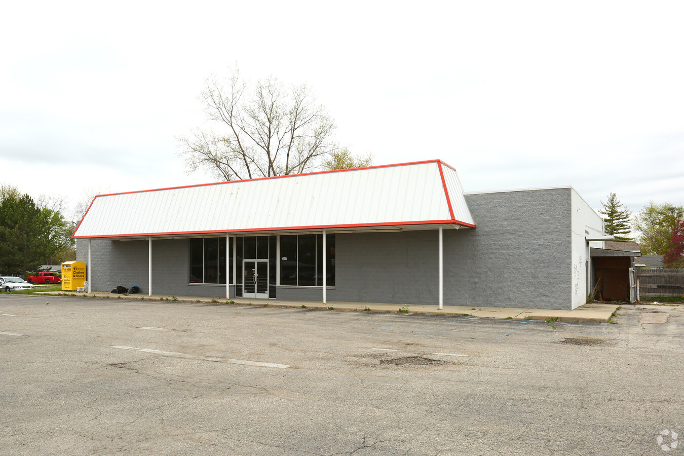


This Property Is For Sale
Current Lease Availabilities
NEARBY LISTINGS FOR SALE OR LEASE
Property Detail
7067 N Saginaw Rd
Flint, MI
Park
14-12-578-085
LOTS 6 & 7 & N 1/2 OF LOT 8 & LOT 73 STANELY PARK (94) FR J-5366--, J-5433--
Commercialnec
Genesee
X
Michigan
26049C0177D
6-8,73
2024
0.73 AC
2024
Flint
010305
Detroit
DEMOGRAPHICS near 7067 N Saginaw Rd
1 Mile
3 Mile
5 Mile
2024 Total Population
5,002
30,155
79,825
2029 Population
4,929
30,453
81,177
Pop Growth 2024-2029
(1.46%)
+ 0.99%
+ 1.69%
Average Age
38
39
40
2024 Total Households
2,011
12,319
32,811
HH Growth 2024-2029
(1.49%)
+ 0.99%
+ 1.72%
Median Household Inc
$39,541
$34,799
$37,215
Avg Household Size
2.40
2.40
2.30
2024 Avg HH Vehicles
2.00
1.00
1.00
Median Home Value
$72,865
$68,243
$76,078
Median Year Built
1958
1962
1963
Nearby Places
- Restaurants
- Banks
- Shops
- Fitness
- Groceries
PUBLIC TRANSPORTATION
COMMUTER RAIL
Flint Amtrak Station (Blue Water - Amtrak)
DRIVE
WALK
Distance
Flint Amtrak Station (Blue Water - Amtrak)
14 min
7.6 mi
AIRPORT
Bishop International
DRIVE
WALK
Distance
Bishop International
29 min
15.5 mi
Freight Ports
Port of Toledo
DRIVE
WALK
Distance
Port of Toledo
144 min
122.9 mi
Nearby Properties
Address
Land Use
TOTAL SIZE
Lot Size
Zoning
Address
Land Use
TOTAL SIZE
Lot Size
Zoning
2,629 SF
119.59 AC
R-4 MANUF
Address
Land Use
TOTAL SIZE
Lot Size
Zoning
46,808 SF
32.06 AC
I-2 HVY IN
Address
Land Use
TOTAL SIZE
Lot Size
Zoning
114,888 SF
11.86 AC
I-2 HVY IN
Address
Land Use
TOTAL SIZE
Lot Size
Zoning
101,744 SF
4.90 AC
Address
Land Use
TOTAL SIZE
Lot Size
Zoning
94,807 SF
7.55 AC
R-1 SF PUD
Address
Land Use
TOTAL SIZE
Lot Size
Zoning
97,898 SF
11.30 AC
R-1 SF PUD
Address
Land Use
TOTAL SIZE
Lot Size
Zoning
9,934 SF
9.70 AC
I-2 HVY IN
Address
Land Use
TOTAL SIZE
Lot Size
Zoning
77,994 SF
5.68 AC
RU-2
Address
Land Use
TOTAL SIZE
Lot Size
Zoning
76,051 SF
8.31 AC
C-2 HWY CO
Address
Land Use
TOTAL SIZE
Lot Size
Zoning
Address
Land Use
TOTAL SIZE
Lot Size
Zoning
7.33 AC
Address
Land Use
TOTAL SIZE
Lot Size
Zoning
Address
Land Use
TOTAL SIZE
Lot Size
Zoning
19.75 AC
Address
Land Use
TOTAL SIZE
Lot Size
Zoning
9,238 SF
84.53 AC
MHP
Address
Land Use
TOTAL SIZE
Lot Size
Zoning
3,434 SF
5.63 AC
I-1 LHGT I
Address
Land Use
TOTAL SIZE
Lot Size
Zoning
20.06 AC
Address
Land Use
TOTAL SIZE
Lot Size
Zoning
10.15 AC
Address
Land Use
TOTAL SIZE
Lot Size
Zoning
Address
Land Use
TOTAL SIZE
Lot Size
Zoning
54,648 SF
4.68 AC
RU-2
Address
Land Use
TOTAL SIZE
Lot Size
Zoning
163,940 SF
14.53 AC
Address
Land Use
TOTAL SIZE
Lot Size
Zoning
1,430 SF
71.54 AC
R-4 MANUF
Address
Land Use
TOTAL SIZE
Lot Size
Zoning
3.11 AC
Address
Land Use
TOTAL SIZE
Lot Size
Zoning
25,800 SF
4.94 AC
I-2 HVY IN
Address
Land Use
TOTAL SIZE
Lot Size
Zoning
4,681 SF
2.20 AC
D3
Address
Land Use
TOTAL SIZE
Lot Size
Zoning
1.70 AC
Address
Land Use
TOTAL SIZE
Lot Size
Zoning
2.31 AC
Address
Land Use
TOTAL SIZE
Lot Size
Zoning
33,200 SF
3.24 AC
I-1 LHGT I
Address
Land Use
TOTAL SIZE
Lot Size
Zoning
339 SF
26.24 AC
R-4 MANUF
Address
Land Use
TOTAL SIZE
Lot Size
Zoning
Address
Land Use
TOTAL SIZE
Lot Size
Zoning
1,684 SF
0.87 AC
R-1 SF PUD
The World's #1 Commercial Real Estate Marketplace
Connect with us
© 2025 CoStar Group
The information above has been obtained from sources believed reliable. While we do not doubt its accuracy we have not verified it and make no guarantee, warranty or representation about it. It is your responsibility to independently confirm its accuracy and completeness. Any projections, opinions, assumptions, or estimates used are for example only and do not represent the current or future performance of the property. The value of this transaction to you depends on tax and other factors which should be evaluated by your tax, financial, and legal advisors. You and your advisors should conduct a careful, independent investigation of the property to determine to your satisfaction the suitability of the property for your needs.