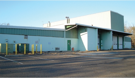
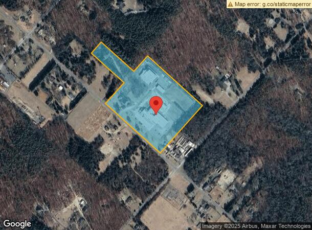
Property Record
707 W Duerer St, Egg Harbor City, NJ 08215
NEARBY LISTINGS FOR SALE OR LEASE
Property Detail
707 W Duerer St
Atlantic City-Hammonton, NJ
Gloucester Farm & Town Assn
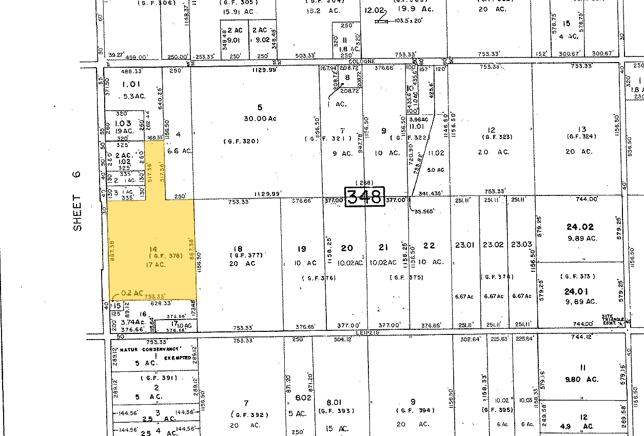
11-00348-0000-00014
Atlantic
Warehouse
New Jersey
ARE
14
34001C0165F
17 AC
2023
Atlantic City/Hammonton
2024
Philadelphia
010401
DEMOGRAPHICS near 707 W Duerer St
1 Mile
3 Mile
5 Mile
2024 Total Population
530
7,716
27,960
2029 Population
515
7,543
27,464
Pop Growth 2024-2029
(2.83%)
(2.24%)
(1.77%)
Average Age
47
41
39
2024 Total Households
216
2,705
9,353
HH Growth 2024-2029
(3.70%)
(3.03%)
(2.52%)
Median Household Inc
$102,083
$81,428
$75,403
Avg Household Size
2.30
2.50
2.60
2024 Avg HH Vehicles
3.00
2.00
2.00
Median Home Value
$260,919
$239,526
$228,583
Median Year Built
1986
1982
1984
Nearby Places
- Restaurants
- Banks
- Shops
- Fitness
- Groceries
PUBLIC TRANSPORTATION
COMMUTER RAIL
Egg Harbor City (Atlantic City Line - NJ Transit Commuter Rail (NJ Transit))
DRIVE
WALK
Distance
Egg Harbor City (Atlantic City Line - NJ Transit Commuter Rail (NJ Transit))
8 min
3.9 mi
Absecon (Atlantic City Line - NJ Transit Commuter Rail (NJ Transit))
DRIVE
WALK
Distance
Absecon (Atlantic City Line - NJ Transit Commuter Rail (NJ Transit))
13 min
9.3 mi
AIRPORT
Atlantic City International
DRIVE
WALK
Distance
Atlantic City International
31 min
8.0 mi
Freight Ports
Broadway Terminal - Pier 5
DRIVE
WALK
Distance
Broadway Terminal - Pier 5
59 min
43.6 mi
Nearby Properties
Address
Land Use
TOTAL SIZE
Lot Size
Zoning
Address
Land Use
TOTAL SIZE
Lot Size
Zoning
35.65 AC
IRD
Address
Land Use
TOTAL SIZE
Lot Size
Zoning
68,744 SF
5.03 AC
R-11
Address
Land Use
TOTAL SIZE
Lot Size
Zoning
4.50 AC
R-1
Address
Land Use
TOTAL SIZE
Lot Size
Zoning
16.39 AC
R-1
Address
Land Use
TOTAL SIZE
Lot Size
Zoning
Address
Land Use
TOTAL SIZE
Lot Size
Zoning
21.60 AC
IRD
Address
Land Use
TOTAL SIZE
Lot Size
Zoning
2.27 AC
R-9
Address
Land Use
TOTAL SIZE
Lot Size
Zoning
17.60 AC
R-5
Address
Land Use
TOTAL SIZE
Lot Size
Zoning
Address
Land Use
TOTAL SIZE
Lot Size
Zoning
21,056 SF
5.23 AC
IND
Address
Land Use
TOTAL SIZE
Lot Size
Zoning
Address
Land Use
TOTAL SIZE
Lot Size
Zoning
1,056 SF
11.56 AC
I
Address
Land Use
TOTAL SIZE
Lot Size
Zoning
4,652 SF
14.80 AC
HC-2
Address
Land Use
TOTAL SIZE
Lot Size
Zoning
1,390 SF
1.92 AC
HC-2
Address
Land Use
TOTAL SIZE
Lot Size
Zoning
Address
Land Use
TOTAL SIZE
Lot Size
Zoning
Address
Land Use
TOTAL SIZE
Lot Size
Zoning
31.90 AC
TI
Address
Land Use
TOTAL SIZE
Lot Size
Zoning
27,200 SF
5.27 AC
HC-2
Address
Land Use
TOTAL SIZE
Lot Size
Zoning
6,256 SF
4.55 AC
R-22
Address
Land Use
TOTAL SIZE
Lot Size
Zoning
4.13 AC
CRR
Address
Land Use
TOTAL SIZE
Lot Size
Zoning
1,790.88 AC
Address
Land Use
TOTAL SIZE
Lot Size
Zoning
8.40 AC
HC-1
Address
Land Use
TOTAL SIZE
Lot Size
Zoning
31.06 AC
IRD
Address
Land Use
TOTAL SIZE
Lot Size
Zoning
3.10 AC
VR
Address
Land Use
TOTAL SIZE
Lot Size
Zoning
1,612.50 AC
Address
Land Use
TOTAL SIZE
Lot Size
Zoning
1,597.03 AC
Address
Land Use
TOTAL SIZE
Lot Size
Zoning
23,500 SF
2.27 AC
H-C
Address
Land Use
TOTAL SIZE
Lot Size
Zoning
2.15 AC
H-C
Address
Land Use
TOTAL SIZE
Lot Size
Zoning
9,972 SF
0.69 AC
R-6
Address
Land Use
TOTAL SIZE
Lot Size
Zoning
3.88 AC
HC-2
The World's #1 Commercial Real Estate Marketplace
Connect with us
© 2025 CoStar Group
The information above has been obtained from sources believed reliable. While we do not doubt its accuracy we have not verified it and make no guarantee, warranty or representation about it. It is your responsibility to independently confirm its accuracy and completeness. Any projections, opinions, assumptions, or estimates used are for example only and do not represent the current or future performance of the property. The value of this transaction to you depends on tax and other factors which should be evaluated by your tax, financial, and legal advisors. You and your advisors should conduct a careful, independent investigation of the property to determine to your satisfaction the suitability of the property for your needs.