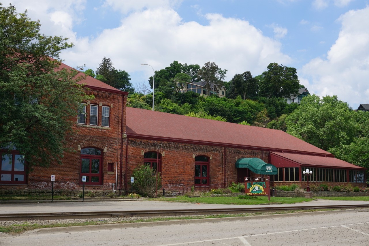
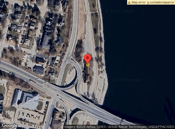
Property Record
710 N Front St, Burlington, IA 52601
NEARBY LISTINGS FOR SALE OR LEASE
Property Detail
710 N Front St
11-33-311-901
Original City
Restaurantbuilding
LAND OWNED BY CITY OF BURL
AE
Des Moines
19057C0278E
Iowa
2024
0.03 AC
2024
Other Market Areas
000200
Burlington, IA-IL
12,840 SF
DEMOGRAPHICS near 710 N Front St
1 Mile
3 Mile
5 Mile
2024 Total Population
4,801
24,073
28,837
2029 Population
4,749
23,498
28,198
Pop Growth 2024-2029
(1.08%)
(2.39%)
(2.22%)
Average Age
37
42
42
2024 Total Households
2,024
10,702
12,756
HH Growth 2024-2029
(0.89%)
(2.45%)
(2.28%)
Median Household Inc
$43,060
$48,760
$51,080
Avg Household Size
2.30
2.20
2.20
2024 Avg HH Vehicles
2.00
2.00
2.00
Median Home Value
$71,510
$103,575
$117,738
Median Year Built
1945
1949
1952
Nearby Places
- Restaurants
- Banks
- Shops
- Fitness
- Groceries
PUBLIC TRANSPORTATION
COMMUTER RAIL
Burlington Amtrak Station (California Zephyr - Amtrak)
DRIVE
WALK
Distance
Burlington Amtrak Station (California Zephyr - Amtrak)
3 min
13 min
0.7 mi
Freight Ports
Port Milwaukee
DRIVE
WALK
Distance
Port Milwaukee
320 min
282.3 mi
SALE & LEASE HISTORY
LISTING DATE
SALE/LEASE

Mar 04, 2019
For Sale
Nearby Properties
Address
Land Use
TOTAL SIZE
Lot Size
Zoning
Address
Land Use
TOTAL SIZE
Lot Size
Zoning
162,378 SF
9.47 AC
Address
Land Use
TOTAL SIZE
Lot Size
Zoning
411,660 SF
35.16 AC
Address
Land Use
TOTAL SIZE
Lot Size
Zoning
12,768 SF
489.69 AC
R1
Address
Land Use
TOTAL SIZE
Lot Size
Zoning
140,614 SF
31.84 AC
M2
Address
Land Use
TOTAL SIZE
Lot Size
Zoning
25,884 SF
13.02 AC
Address
Land Use
TOTAL SIZE
Lot Size
Zoning
113,727 SF
9.64 AC
Address
Land Use
TOTAL SIZE
Lot Size
Zoning
95,304 SF
10.29 AC
Address
Land Use
TOTAL SIZE
Lot Size
Zoning
407 SF
10.24 AC
Address
Land Use
TOTAL SIZE
Lot Size
Zoning
22,460 SF
21.33 AC
R2
Address
Land Use
TOTAL SIZE
Lot Size
Zoning
873,791 SF
139.78 AC
M2
Address
Land Use
TOTAL SIZE
Lot Size
Zoning
391,962 SF
17.04 AC
M2
Address
Land Use
TOTAL SIZE
Lot Size
Zoning
58,769 SF
7.56 AC
C2
Address
Land Use
TOTAL SIZE
Lot Size
Zoning
45,054 SF
14.15 AC
M2
Address
Land Use
TOTAL SIZE
Lot Size
Zoning
77,637 SF
13.99 AC
Address
Land Use
TOTAL SIZE
Lot Size
Zoning
25,818 SF
2.66 AC
C3
Address
Land Use
TOTAL SIZE
Lot Size
Zoning
18,151 SF
8.01 AC
Address
Land Use
TOTAL SIZE
Lot Size
Zoning
28,120 SF
2.90 AC
Address
Land Use
TOTAL SIZE
Lot Size
Zoning
18,350 SF
5 AC
Address
Land Use
TOTAL SIZE
Lot Size
Zoning
12,673 SF
12.90 AC
Address
Land Use
TOTAL SIZE
Lot Size
Zoning
168,771 SF
20.07 AC
Address
Land Use
TOTAL SIZE
Lot Size
Zoning
68,776 SF
5.89 AC
B2
Address
Land Use
TOTAL SIZE
Lot Size
Zoning
650 SF
6.12 AC
R4
Address
Land Use
TOTAL SIZE
Lot Size
Zoning
134,068 SF
40.60 AC
R2
Address
Land Use
TOTAL SIZE
Lot Size
Zoning
61,245 SF
2.72 AC
Address
Land Use
TOTAL SIZE
Lot Size
Zoning
3,998 SF
11.52 AC
Address
Land Use
TOTAL SIZE
Lot Size
Zoning
12,988 SF
2.62 AC
Address
Land Use
TOTAL SIZE
Lot Size
Zoning
367,266 SF
38.70 AC
I3
Address
Land Use
TOTAL SIZE
Lot Size
Zoning
60,646 SF
8.58 AC
Address
Land Use
TOTAL SIZE
Lot Size
Zoning
4,896 SF
7.66 AC
Address
Land Use
TOTAL SIZE
Lot Size
Zoning
140,784 SF
22.87 AC
M2
The World's #1 Commercial Real Estate Marketplace
Connect with us
© 2025 CoStar Group
The information above has been obtained from sources believed reliable. While we do not doubt its accuracy we have not verified it and make no guarantee, warranty or representation about it. It is your responsibility to independently confirm its accuracy and completeness. Any projections, opinions, assumptions, or estimates used are for example only and do not represent the current or future performance of the property. The value of this transaction to you depends on tax and other factors which should be evaluated by your tax, financial, and legal advisors. You and your advisors should conduct a careful, independent investigation of the property to determine to your satisfaction the suitability of the property for your needs.