Property Record
7100 Roswell Rd, Atlanta, GA 30328

NEARBY LISTINGS FOR SALE OR LEASE
-
-
View all Atlanta listings for sale on LoopNet.com
Property Detail
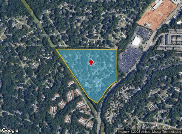
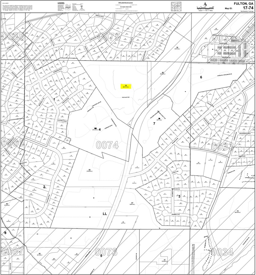
7100 Roswell Rd
Atlanta-Sandy Springs-Roswell, GA
S Atlanta Land Co
17-0074-LL-019-6
30 B
Apartment
Fulton
X
Georgia
13089C0005K
30
2023
22.67 AC
2023
Sandy Springs
010216
Atlanta
325,440 SF
DEMOGRAPHICS near 7100 Roswell Rd
1 Mile
3 Mile
5 Mile
2024 Total Population
13,427
94,661
212,128
2029 Population
13,674
95,843
214,074
Pop Growth 2024-2029
+ 1.84%
+ 1.25%
+ 0.92%
Average Age
38
39
40
2024 Total Households
6,215
42,499
90,008
HH Growth 2024-2029
+ 1.87%
+ 1.38%
+ 1.03%
Median Household Inc
$93,659
$97,025
$111,094
Avg Household Size
2.10
2.20
2.30
2024 Avg HH Vehicles
2.00
2.00
2.00
Median Home Value
$428,715
$582,967
$596,450
Median Year Built
1980
1987
1985
Nearby Places
- Restaurants
- Banks
- Shops
- Fitness
- Groceries
PUBLIC TRANSPORTATION
AIRPORT
Hartsfield - Jackson Atlanta International
DRIVE
WALK
Distance
Hartsfield - Jackson Atlanta International
38 min
26.0 mi
Freight Ports
Georgia Ports - Savannah
DRIVE
WALK
Distance
Georgia Ports - Savannah
301 min
265.3 mi
Nearby Properties
Address
Land Use
TOTAL SIZE
Lot Size
Zoning
Address
Land Use
TOTAL SIZE
Lot Size
Zoning
1,123,714 SF
47.33 AC
C1
Address
Land Use
TOTAL SIZE
Lot Size
Zoning
854,744 SF
1.95 AC
OI
Address
Land Use
TOTAL SIZE
Lot Size
Zoning
374,311 SF
0.19 AC
X
Address
Land Use
TOTAL SIZE
Lot Size
Zoning
216,464 SF
X
Address
Land Use
TOTAL SIZE
Lot Size
Zoning
617,125 SF
125.51 AC
AC
Address
Land Use
TOTAL SIZE
Lot Size
Zoning
104,625 SF
0.99 AC
X
Address
Land Use
TOTAL SIZE
Lot Size
Zoning
376,010 SF
3.80 AC
OI
Address
Land Use
TOTAL SIZE
Lot Size
Zoning
1,088,359 SF
7.07 AC
OIC
Address
Land Use
TOTAL SIZE
Lot Size
Zoning
699,202 SF
13.90 AC
OIC
Address
Land Use
TOTAL SIZE
Lot Size
Zoning
316,391 SF
11.50 AC
OCR
Address
Land Use
TOTAL SIZE
Lot Size
Zoning
1,119,177 SF
5.21 AC
OIC
Address
Land Use
TOTAL SIZE
Lot Size
Zoning
907,800 SF
2.65 AC
Address
Land Use
TOTAL SIZE
Lot Size
Zoning
406,188 SF
4.43 AC
X
Address
Land Use
TOTAL SIZE
Lot Size
Zoning
258,909 SF
19.20 AC
X
Address
Land Use
TOTAL SIZE
Lot Size
Zoning
1,067,348 SF
6.41 AC
OIC
Address
Land Use
TOTAL SIZE
Lot Size
Zoning
664,199 SF
2.84 AC
Address
Land Use
TOTAL SIZE
Lot Size
Zoning
478,332 SF
4.07 AC
Address
Land Use
TOTAL SIZE
Lot Size
Zoning
588,846 SF
3.80 AC
Address
Land Use
TOTAL SIZE
Lot Size
Zoning
409,493 SF
9.90 AC
OI
Address
Land Use
TOTAL SIZE
Lot Size
Zoning
543,420 SF
4.15 AC
Address
Land Use
TOTAL SIZE
Lot Size
Zoning
519,706 SF
6.50 AC
X
Address
Land Use
TOTAL SIZE
Lot Size
Zoning
892,367 SF
3.37 AC
OIC
Address
Land Use
TOTAL SIZE
Lot Size
Zoning
1,430,700 SF
5.77 AC
OIC
Address
Land Use
TOTAL SIZE
Lot Size
Zoning
480,790 SF
5.93 AC
Address
Land Use
TOTAL SIZE
Lot Size
Zoning
296,627 SF
9.10 AC
X
Address
Land Use
TOTAL SIZE
Lot Size
Zoning
426,957 SF
38.75 AC
AC
Address
Land Use
TOTAL SIZE
Lot Size
Zoning
572,181 SF
3.76 AC
C1
Address
Land Use
TOTAL SIZE
Lot Size
Zoning
732,923 SF
2.77 AC
OIC
Address
Land Use
TOTAL SIZE
Lot Size
Zoning
274,733 SF
4.50 AC
OIC
Address
Land Use
TOTAL SIZE
Lot Size
Zoning
732,896 SF
3.96 AC
OIC
The World's #1 Commercial Real Estate Marketplace
Connect with us
© 2025 CoStar Group
The information above has been obtained from sources believed reliable. While we do not doubt its accuracy we have not verified it and make no guarantee, warranty or representation about it. It is your responsibility to independently confirm its accuracy and completeness. Any projections, opinions, assumptions, or estimates used are for example only and do not represent the current or future performance of the property. The value of this transaction to you depends on tax and other factors which should be evaluated by your tax, financial, and legal advisors. You and your advisors should conduct a careful, independent investigation of the property to determine to your satisfaction the suitability of the property for your needs.