Property Record
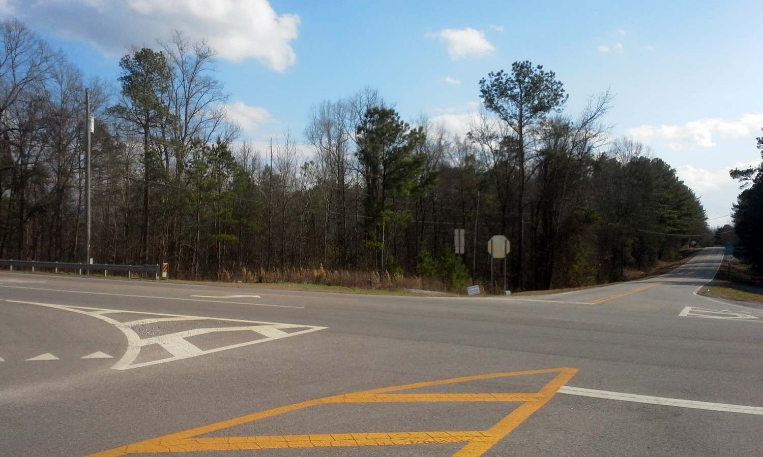
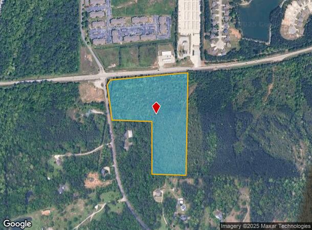
42 Highway 70, Calera, AL 35040
This Property Is For Sale
NEARBY LISTINGS FOR SALE OR LEASE
Property Detail
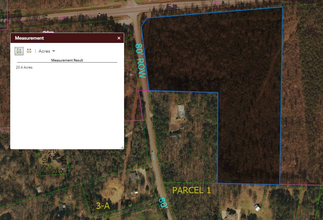
42 Highway 70
22-8-34-4-001-006-000
BEG INT E ROW CO RD 42 & S ROW HWY 70 E985(S) S TO S LN SEC 34 W435(S) N670(S) W TO ROW CO RD 42 NLY TO POB
Vacantlandnec
Shelby
X
Alabama
01117C0413E
20 AC
2023
I-65 Corr/S Shelby County
2023
Birmingham
030504
Birmingham-Hoover, AL
DEMOGRAPHICS near 42 Highway 70
1 Mile
3 Mile
5 Mile
2024 Total Population
2,779
10,436
23,659
2029 Population
2,989
11,340
25,868
Pop Growth 2024-2029
+ 7.56%
+ 8.66%
+ 9.34%
Average Age
36
36
37
2024 Total Households
1,098
3,990
8,834
HH Growth 2024-2029
+ 7.74%
+ 8.80%
+ 9.47%
Median Household Inc
$80,427
$76,284
$72,258
Avg Household Size
2.50
2.60
2.60
2024 Avg HH Vehicles
2.00
2.00
2.00
Median Home Value
$191,994
$198,707
$210,446
Median Year Built
2005
2004
2003
Nearby Places
- Restaurants
- Banks
- Shops
- Fitness
- Groceries
PUBLIC TRANSPORTATION
AIRPORT
Birmingham-Shuttlesworth International
DRIVE
WALK
Distance
Birmingham-Shuttlesworth International
46 min
36.5 mi
Freight Ports
Port of Mobile
DRIVE
WALK
Distance
Port of Mobile
249 min
228.9 mi
Nearby Properties
Address
Land Use
TOTAL SIZE
Lot Size
Zoning
Address
Land Use
TOTAL SIZE
Lot Size
Zoning
573,600 SF
19.96 AC
Address
Land Use
TOTAL SIZE
Lot Size
Zoning
14,160 SF
6.75 AC
Address
Land Use
TOTAL SIZE
Lot Size
Zoning
139,905 SF
34.78 AC
Address
Land Use
TOTAL SIZE
Lot Size
Zoning
3,941 SF
5.60 AC
Address
Land Use
TOTAL SIZE
Lot Size
Zoning
368,066 SF
20.66 AC
Address
Land Use
TOTAL SIZE
Lot Size
Zoning
6,234 SF
33 AC
Address
Land Use
TOTAL SIZE
Lot Size
Zoning
270,600 SF
21.74 AC
Address
Land Use
TOTAL SIZE
Lot Size
Zoning
46,031 SF
11.09 AC
Address
Land Use
TOTAL SIZE
Lot Size
Zoning
208,000 SF
11.91 AC
Address
Land Use
TOTAL SIZE
Lot Size
Zoning
104,643 SF
5.39 AC
Address
Land Use
TOTAL SIZE
Lot Size
Zoning
53,022 SF
2.20 AC
Address
Land Use
TOTAL SIZE
Lot Size
Zoning
241.36 AC
Address
Land Use
TOTAL SIZE
Lot Size
Zoning
73,825 SF
15 AC
Address
Land Use
TOTAL SIZE
Lot Size
Zoning
14,163 SF
12.78 AC
Address
Land Use
TOTAL SIZE
Lot Size
Zoning
38,816 SF
33.96 AC
Address
Land Use
TOTAL SIZE
Lot Size
Zoning
38,429 SF
4.28 AC
Address
Land Use
TOTAL SIZE
Lot Size
Zoning
30,000 SF
10.06 AC
Address
Land Use
TOTAL SIZE
Lot Size
Zoning
36,430 SF
4.10 AC
Address
Land Use
TOTAL SIZE
Lot Size
Zoning
66,260 SF
3.84 AC
Address
Land Use
TOTAL SIZE
Lot Size
Zoning
17,950 SF
8.89 AC
Address
Land Use
TOTAL SIZE
Lot Size
Zoning
6.40 AC
Address
Land Use
TOTAL SIZE
Lot Size
Zoning
1,200 SF
3.92 AC
Address
Land Use
TOTAL SIZE
Lot Size
Zoning
10,268 SF
5 AC
Address
Land Use
TOTAL SIZE
Lot Size
Zoning
5,000 SF
9.30 AC
Address
Land Use
TOTAL SIZE
Lot Size
Zoning
6,142 SF
1.70 AC
Address
Land Use
TOTAL SIZE
Lot Size
Zoning
9,945 SF
2.27 AC
Address
Land Use
TOTAL SIZE
Lot Size
Zoning
5,105 SF
1.32 AC
Address
Land Use
TOTAL SIZE
Lot Size
Zoning
5,956 SF
2.06 AC
The World's #1 Commercial Real Estate Marketplace
Connect with us
© 2025 CoStar Group
The information above has been obtained from sources believed reliable. While we do not doubt its accuracy we have not verified it and make no guarantee, warranty or representation about it. It is your responsibility to independently confirm its accuracy and completeness. Any projections, opinions, assumptions, or estimates used are for example only and do not represent the current or future performance of the property. The value of this transaction to you depends on tax and other factors which should be evaluated by your tax, financial, and legal advisors. You and your advisors should conduct a careful, independent investigation of the property to determine to your satisfaction the suitability of the property for your needs.