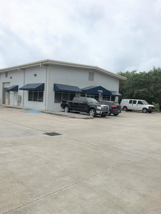
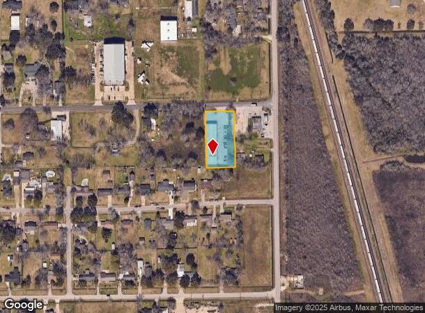
Property Record
7102 Brookside Rd, Pearland, TX 77581
NEARBY LISTINGS FOR SALE OR LEASE
Property Detail
7102 Brookside Rd
Houston-The Woodlands-Sugar Land, TX
Brookside
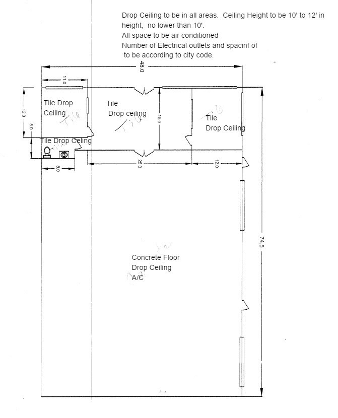
2210-0003-010
BROOKSIDE BLK 1 LOT 1 (REPLAT) ACRES 0.7421
Commercialnec
Brazoria
AE
Texas
48039C0035K
1
2023
0.74 AC
2023
South Hwy 35
660504
Houston
9,350 SF
DEMOGRAPHICS near 7102 Brookside Rd
1 Mile
3 Mile
5 Mile
2024 Total Population
1,897
60,474
204,909
2029 Population
2,108
64,773
215,981
Pop Growth 2024-2029
+ 11.12%
+ 7.11%
+ 5.40%
Average Age
37
35
36
2024 Total Households
610
19,692
68,173
HH Growth 2024-2029
+ 11.31%
+ 7.36%
+ 5.51%
Median Household Inc
$99,547
$80,021
$77,329
Avg Household Size
3.00
3.00
2.90
2024 Avg HH Vehicles
2.00
2.00
2.00
Median Home Value
$256,321
$244,391
$238,899
Median Year Built
1987
1999
1994
Nearby Places
- Restaurants
- Banks
- Shops
- Fitness
- Groceries
PUBLIC TRANSPORTATION
AIRPORT
William P Hobby
DRIVE
WALK
Distance
William P Hobby
14 min
5.7 mi
George Bush Intcntl/Houston
DRIVE
WALK
Distance
George Bush Intcntl/Houston
48 min
32.1 mi
Freight Ports
Port of Houston
DRIVE
WALK
Distance
Port of Houston
25 min
13.9 mi
SALE & LEASE HISTORY
LISTING DATE
SALE/LEASE

Sep 28, 2016
For Lease
May 03, 2021
For Lease
Jul 05, 2024
For Lease
Jan 30, 2018
For Lease
Nearby Properties
Address
Land Use
TOTAL SIZE
Lot Size
Zoning
Address
Land Use
TOTAL SIZE
Lot Size
Zoning
1,214,720 SF
92.85 AC
Address
Land Use
TOTAL SIZE
Lot Size
Zoning
359,985 SF
12.56 AC
Address
Land Use
TOTAL SIZE
Lot Size
Zoning
252,472 SF
13.28 AC
Address
Land Use
TOTAL SIZE
Lot Size
Zoning
421,680 SF
23.44 AC
Address
Land Use
TOTAL SIZE
Lot Size
Zoning
309,102 SF
16.81 AC
Address
Land Use
TOTAL SIZE
Lot Size
Zoning
236,642 SF
11.48 AC
Address
Land Use
TOTAL SIZE
Lot Size
Zoning
285,328 SF
40.75 AC
Address
Land Use
TOTAL SIZE
Lot Size
Zoning
128,754 SF
14.83 AC
Address
Land Use
TOTAL SIZE
Lot Size
Zoning
72,543 SF
22.64 AC
Address
Land Use
TOTAL SIZE
Lot Size
Zoning
14.93 AC
Address
Land Use
TOTAL SIZE
Lot Size
Zoning
144,879 SF
8.91 AC
Address
Land Use
TOTAL SIZE
Lot Size
Zoning
134,596 SF
7.21 AC
Address
Land Use
TOTAL SIZE
Lot Size
Zoning
89.23 AC
Address
Land Use
TOTAL SIZE
Lot Size
Zoning
100,549 SF
18.25 AC
Address
Land Use
TOTAL SIZE
Lot Size
Zoning
195,856 SF
20.81 AC
Address
Land Use
TOTAL SIZE
Lot Size
Zoning
157,128 SF
10 AC
0041
Address
Land Use
TOTAL SIZE
Lot Size
Zoning
148,902 SF
11.40 AC
Address
Land Use
TOTAL SIZE
Lot Size
Zoning
165,880 SF
19.20 AC
Address
Land Use
TOTAL SIZE
Lot Size
Zoning
217,275 SF
26.83 AC
Address
Land Use
TOTAL SIZE
Lot Size
Zoning
114,828 SF
7.94 AC
Address
Land Use
TOTAL SIZE
Lot Size
Zoning
129,025 SF
7.02 AC
Address
Land Use
TOTAL SIZE
Lot Size
Zoning
67,218 SF
32.01 AC
Address
Land Use
TOTAL SIZE
Lot Size
Zoning
291,181 SF
11.07 AC
Address
Land Use
TOTAL SIZE
Lot Size
Zoning
71,340 SF
47.16 AC
Address
Land Use
TOTAL SIZE
Lot Size
Zoning
56.27 AC
Address
Land Use
TOTAL SIZE
Lot Size
Zoning
106,341 SF
12.12 AC
0550
Address
Land Use
TOTAL SIZE
Lot Size
Zoning
81,609 SF
6.56 AC
Address
Land Use
TOTAL SIZE
Lot Size
Zoning
45,108 SF
3.74 AC
Address
Land Use
TOTAL SIZE
Lot Size
Zoning
49.29 AC
0007
Address
Land Use
TOTAL SIZE
Lot Size
Zoning
86,550 SF
8.45 AC
The World's #1 Commercial Real Estate Marketplace
Connect with us
© 2025 CoStar Group
The information above has been obtained from sources believed reliable. While we do not doubt its accuracy we have not verified it and make no guarantee, warranty or representation about it. It is your responsibility to independently confirm its accuracy and completeness. Any projections, opinions, assumptions, or estimates used are for example only and do not represent the current or future performance of the property. The value of this transaction to you depends on tax and other factors which should be evaluated by your tax, financial, and legal advisors. You and your advisors should conduct a careful, independent investigation of the property to determine to your satisfaction the suitability of the property for your needs.