Property Record
711 East Hwy, Pembroke, NC 28372

NEARBY LISTINGS FOR SALE OR LEASE
Property Detail
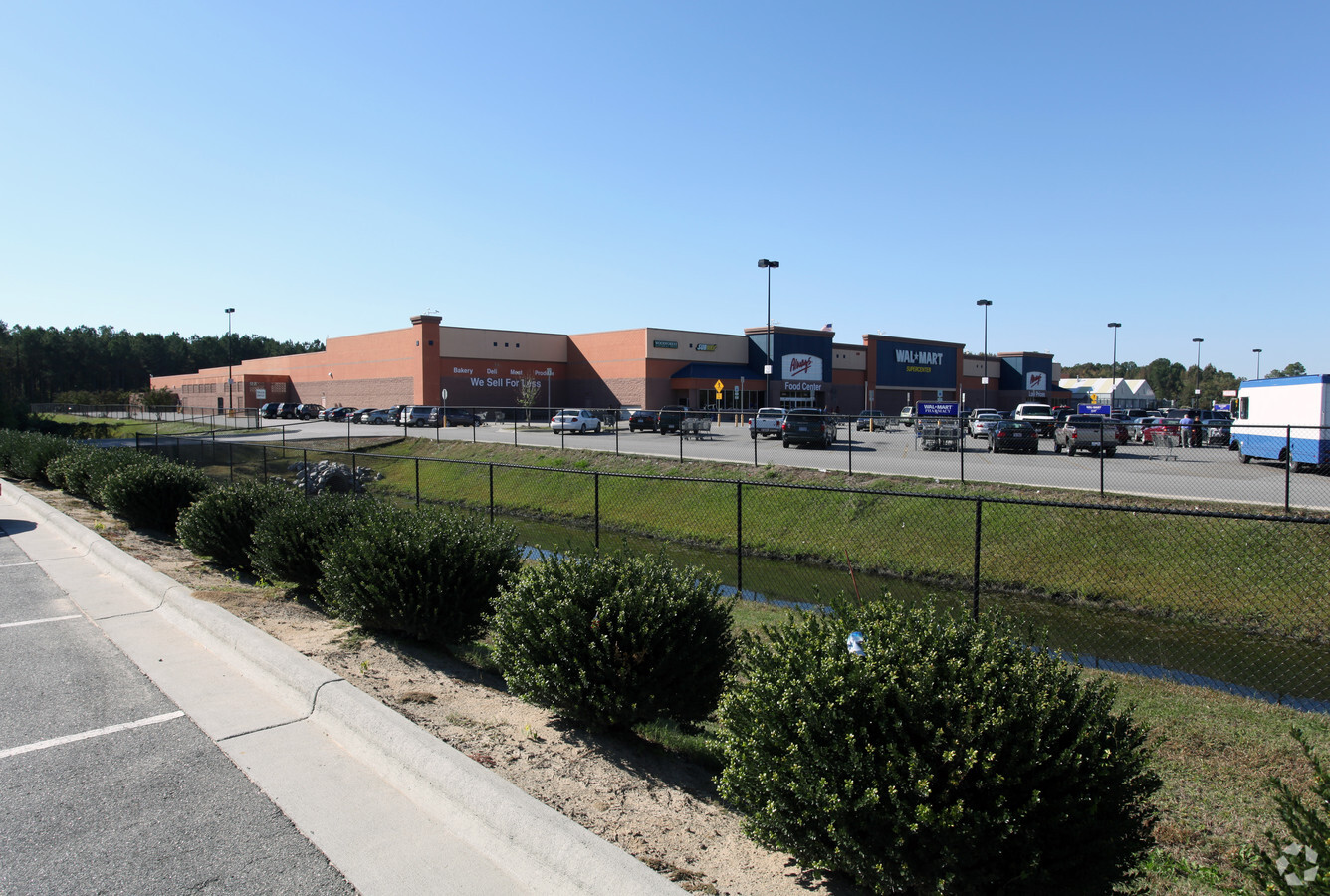
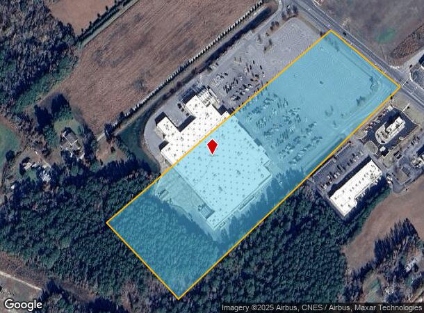
711 East Hwy
1411-01-00301B
AC SW/S HWY 711
Regionalshoppingcenterormallwithanchorstore
Robeson
X
North Carolina
3710934300K
14.05 AC
2024
North Carolina Southeast Area
2024
Other Market Areas
960501
Lumberton, NC
DEMOGRAPHICS near 711 East Hwy
1 Mile
3 Mile
5 Mile
2024 Total Population
1,767
9,842
18,167
2029 Population
1,777
9,643
17,828
Pop Growth 2024-2029
+ 0.57%
(2.02%)
(1.87%)
Average Age
36
34
36
2024 Total Households
676
3,102
6,164
HH Growth 2024-2029
+ 0.44%
(2.22%)
(1.98%)
Median Household Inc
$26,718
$31,580
$34,089
Avg Household Size
2.50
2.50
2.60
2024 Avg HH Vehicles
2.00
2.00
2.00
Median Home Value
$101,905
$98,767
$95,266
Median Year Built
1985
1986
1987
Nearby Places
- Restaurants
- Banks
- Shops
- Fitness
- Groceries
PUBLIC TRANSPORTATION
AIRPORT
Fayetteville Regional/Grannis Field
DRIVE
WALK
Distance
Fayetteville Regional/Grannis Field
52 min
38.4 mi
Freight Ports
Port of Wilmington
DRIVE
WALK
Distance
Port of Wilmington
118 min
89.1 mi
Nearby Properties
Address
Land Use
TOTAL SIZE
Lot Size
Zoning
Address
Land Use
TOTAL SIZE
Lot Size
Zoning
137,708 SF
59.92 AC
OI
Address
Land Use
TOTAL SIZE
Lot Size
Zoning
15,926 SF
4.09 AC
R
Address
Land Use
TOTAL SIZE
Lot Size
Zoning
53,400 SF
13.03 AC
Address
Land Use
TOTAL SIZE
Lot Size
Zoning
17,985 SF
9.21 AC
OI
Address
Land Use
TOTAL SIZE
Lot Size
Zoning
161,304 SF
7.91 AC
RA
Address
Land Use
TOTAL SIZE
Lot Size
Zoning
16,764 SF
6 AC
RA
Address
Land Use
TOTAL SIZE
Lot Size
Zoning
49,780 SF
40.23 AC
OI
Address
Land Use
TOTAL SIZE
Lot Size
Zoning
85,885 SF
23.93 AC
RA
Address
Land Use
TOTAL SIZE
Lot Size
Zoning
34,131 SF
45 AC
Address
Land Use
TOTAL SIZE
Lot Size
Zoning
14,124 SF
12.82 AC
RMF
Address
Land Use
TOTAL SIZE
Lot Size
Zoning
1,334 SF
22.42 AC
R
Address
Land Use
TOTAL SIZE
Lot Size
Zoning
22,018 SF
3.79 AC
RA
Address
Land Use
TOTAL SIZE
Lot Size
Zoning
38,184 SF
12.30 AC
RA
Address
Land Use
TOTAL SIZE
Lot Size
Zoning
17,808 SF
28.37 AC
RA
Address
Land Use
TOTAL SIZE
Lot Size
Zoning
86,336 SF
28.36 AC
RA
Address
Land Use
TOTAL SIZE
Lot Size
Zoning
14,103 SF
6.28 AC
RA
Address
Land Use
TOTAL SIZE
Lot Size
Zoning
39,381 SF
2 AC
HB
Address
Land Use
TOTAL SIZE
Lot Size
Zoning
10,001 SF
44.16 AC
R
Address
Land Use
TOTAL SIZE
Lot Size
Zoning
18,580 SF
23.89 AC
Address
Land Use
TOTAL SIZE
Lot Size
Zoning
24,721 SF
10.05 AC
OI
Address
Land Use
TOTAL SIZE
Lot Size
Zoning
14,568 SF
5.52 AC
OI
Address
Land Use
TOTAL SIZE
Lot Size
Zoning
14,312 SF
14 AC
RA
Address
Land Use
TOTAL SIZE
Lot Size
Zoning
36,853 SF
4.38 AC
R
Address
Land Use
TOTAL SIZE
Lot Size
Zoning
32,498 SF
0.45 AC
CB
Address
Land Use
TOTAL SIZE
Lot Size
Zoning
2,552 SF
32.54 AC
RA
Address
Land Use
TOTAL SIZE
Lot Size
Zoning
28,263 SF
24.56 AC
RA
Address
Land Use
TOTAL SIZE
Lot Size
Zoning
155,203 SF
30 AC
RA
Address
Land Use
TOTAL SIZE
Lot Size
Zoning
3,144 SF
8.12 AC
R
Address
Land Use
TOTAL SIZE
Lot Size
Zoning
29,196 SF
8 AC
RA
Address
Land Use
TOTAL SIZE
Lot Size
Zoning
23,257 SF
4.16 AC
OI
The World's #1 Commercial Real Estate Marketplace
Connect with us
© 2025 CoStar Group
The information above has been obtained from sources believed reliable. While we do not doubt its accuracy we have not verified it and make no guarantee, warranty or representation about it. It is your responsibility to independently confirm its accuracy and completeness. Any projections, opinions, assumptions, or estimates used are for example only and do not represent the current or future performance of the property. The value of this transaction to you depends on tax and other factors which should be evaluated by your tax, financial, and legal advisors. You and your advisors should conduct a careful, independent investigation of the property to determine to your satisfaction the suitability of the property for your needs.