Property Record
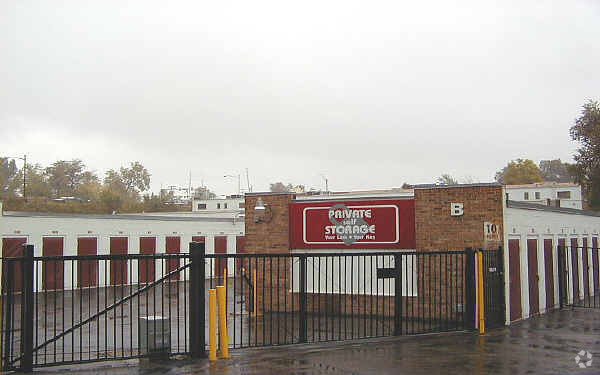
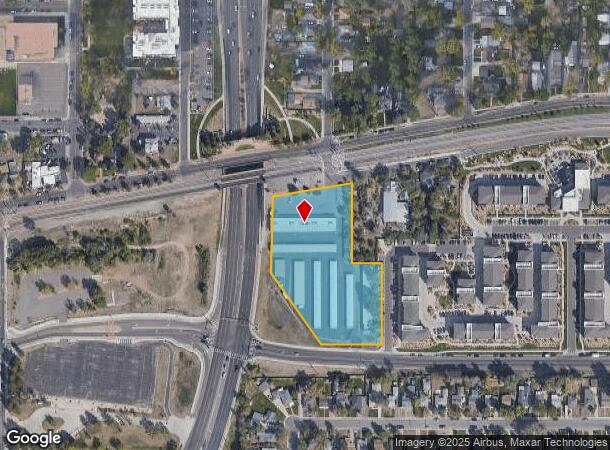
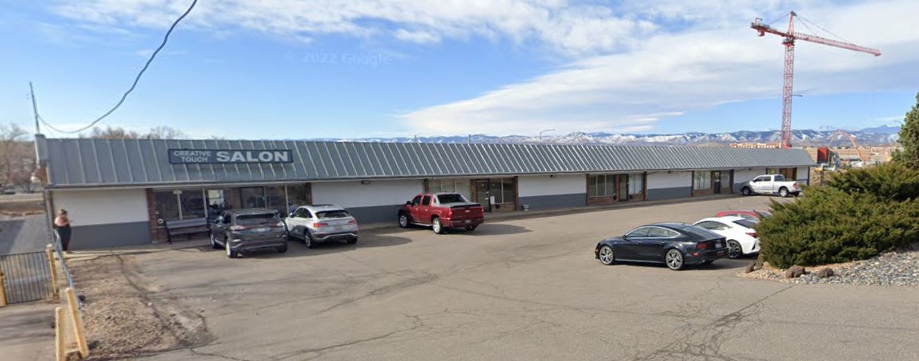
7117 W 56Th Ave, Arvada, CO 80002

Current Lease Availabilities
NEARBY LISTINGS FOR SALE OR LEASE
Property Detail
7117 W 56Th Ave
39-114-22-001
Pony Storage Industrial Park Pd
Industrialgeneral
SECTION 11 TOWNSHIP 03 RANGE 69 QTR SE SUBDIVISIONCD 612200 SUBDIVISIONNAME PONY STORAGE INDUSTRIAL PARK PD BLOCK 001 LOT SIZE: 118010 TRACT 00A VALUE: 2.709
X
Jefferson
08059C0212F
Colorado
2023
2.71 AC
2024
Northwest Denver
010406
Denver
44,500 SF
Denver-Aurora-Lakewood, CO
DEMOGRAPHICS near 7117 W 56Th Ave
1 Mile
3 Mile
5 Mile
2024 Total Population
13,423
125,019
355,354
2029 Population
13,264
124,990
358,412
Pop Growth 2024-2029
(1.18%)
(0.02%)
+ 0.86%
Average Age
39
41
40
2024 Total Households
6,285
52,944
152,105
HH Growth 2024-2029
(1.34%)
(0.14%)
+ 0.81%
Median Household Inc
$66,758
$80,205
$83,246
Avg Household Size
2.10
2.30
2.30
2024 Avg HH Vehicles
2.00
2.00
2.00
Median Home Value
$454,487
$488,522
$519,285
Median Year Built
1973
1970
1973
Nearby Places
- Restaurants
- Banks
- Shops
- Fitness
- Groceries
PUBLIC TRANSPORTATION
COMMUTER RAIL
Olde Town Arvada E-Bound (Union Station to Wheat Ridge Ward Station - Regional Transportation District)
DRIVE
WALK
Distance
Olde Town Arvada E-Bound (Union Station to Wheat Ridge Ward Station - Regional Transportation District)
1 min
6 min
0.3 mi
Olde Town Arvada W-Bound (Union Station to Wheat Ridge Ward Station - Regional Transportation District)
DRIVE
WALK
Distance
Olde Town Arvada W-Bound (Union Station to Wheat Ridge Ward Station - Regional Transportation District)
2 min
7 min
0.4 mi
AIRPORT
Denver International
DRIVE
WALK
Distance
Denver International
37 min
28.5 mi
Freight Ports
Tulsa Port Of Catoosa
DRIVE
WALK
Distance
Tulsa Port Of Catoosa
735 min
714.0 mi
Nearby Properties
Address
Land Use
TOTAL SIZE
Lot Size
Zoning
Address
Land Use
TOTAL SIZE
Lot Size
Zoning
860,132 SF
68.50 AC
R-5
Address
Land Use
TOTAL SIZE
Lot Size
Zoning
398,180 SF
33.31 AC
R1C
Address
Land Use
TOTAL SIZE
Lot Size
Zoning
269,013 SF
31.89 AC
Address
Land Use
TOTAL SIZE
Lot Size
Zoning
111,673 SF
29.06 AC
Address
Land Use
TOTAL SIZE
Lot Size
Zoning
298,150 SF
24.21 AC
Address
Land Use
TOTAL SIZE
Lot Size
Zoning
187,095 SF
23.42 AC
Address
Land Use
TOTAL SIZE
Lot Size
Zoning
436,238 SF
13.94 AC
Address
Land Use
TOTAL SIZE
Lot Size
Zoning
365,230 SF
12.51 AC
Address
Land Use
TOTAL SIZE
Lot Size
Zoning
389,561 SF
10.73 AC
Address
Land Use
TOTAL SIZE
Lot Size
Zoning
142,635 SF
6.84 AC
U-SU-B1
Address
Land Use
TOTAL SIZE
Lot Size
Zoning
6,731 SF
80.77 AC
Address
Land Use
TOTAL SIZE
Lot Size
Zoning
262,699 SF
13.10 AC
A2
Address
Land Use
TOTAL SIZE
Lot Size
Zoning
76,078 SF
6.64 AC
U-SU-C
Address
Land Use
TOTAL SIZE
Lot Size
Zoning
87,567 SF
14.98 AC
R-5
Address
Land Use
TOTAL SIZE
Lot Size
Zoning
115,719 SF
5.93 AC
Address
Land Use
TOTAL SIZE
Lot Size
Zoning
142,200 SF
9.82 AC
Address
Land Use
TOTAL SIZE
Lot Size
Zoning
149,115 SF
18 AC
Address
Land Use
TOTAL SIZE
Lot Size
Zoning
163,361 SF
17.09 AC
Address
Land Use
TOTAL SIZE
Lot Size
Zoning
91,734 SF
9.69 AC
Address
Land Use
TOTAL SIZE
Lot Size
Zoning
83,675 SF
13.43 AC
R2
Address
Land Use
TOTAL SIZE
Lot Size
Zoning
307,377 SF
15.12 AC
Address
Land Use
TOTAL SIZE
Lot Size
Zoning
144,325 SF
13.22 AC
Address
Land Use
TOTAL SIZE
Lot Size
Zoning
114,348 SF
3 AC
Address
Land Use
TOTAL SIZE
Lot Size
Zoning
139,913 SF
2.87 AC
Address
Land Use
TOTAL SIZE
Lot Size
Zoning
113,903 SF
12.25 AC
Address
Land Use
TOTAL SIZE
Lot Size
Zoning
121,389 SF
3.58 AC
Address
Land Use
TOTAL SIZE
Lot Size
Zoning
177,075 SF
8.71 AC
Address
Land Use
TOTAL SIZE
Lot Size
Zoning
474,246 SF
10.89 AC
B-3
Address
Land Use
TOTAL SIZE
Lot Size
Zoning
212,974 SF
26.65 AC
A1
Address
Land Use
TOTAL SIZE
Lot Size
Zoning
86,706 SF
6.36 AC
The World's #1 Commercial Real Estate Marketplace
Connect with us
© 2025 CoStar Group
The information above has been obtained from sources believed reliable. While we do not doubt its accuracy we have not verified it and make no guarantee, warranty or representation about it. It is your responsibility to independently confirm its accuracy and completeness. Any projections, opinions, assumptions, or estimates used are for example only and do not represent the current or future performance of the property. The value of this transaction to you depends on tax and other factors which should be evaluated by your tax, financial, and legal advisors. You and your advisors should conduct a careful, independent investigation of the property to determine to your satisfaction the suitability of the property for your needs.