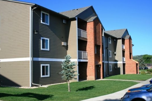
Property Record
715 E Minnesota St, Rapid City, SD 57701
NEARBY LISTINGS FOR SALE OR LEASE
-
-
View all Rapid City listings for sale on LoopNet.com
Property Detail
715 E Minnesota St
Rapid City, SD
Robbinsdale #10
0038310
ROBBINSDALE #10, BLOCK 10, LOT 1R
Multifamilydwelling
Pennington
X
South Dakota
46103C0787H
1r
2023
2.12 AC
2024
Rapid City
010905
Other Market Areas
7,276 SF
DEMOGRAPHICS near 715 E Minnesota St
1 Mile
3 Mile
5 Mile
2024 Total Population
9,671
38,843
82,345
2029 Population
10,804
43,552
91,962
Pop Growth 2024-2029
+ 11.72%
+ 12.12%
+ 11.68%
Average Age
42
41
41
2024 Total Households
4,081
16,527
34,349
HH Growth 2024-2029
+ 12.03%
+ 12.56%
+ 12.04%
Median Household Inc
$63,984
$57,119
$61,378
Avg Household Size
2.20
2.10
2.20
2024 Avg HH Vehicles
2.00
2.00
2.00
Median Home Value
$239,825
$258,636
$253,398
Median Year Built
1988
1983
1982
Nearby Places
- Restaurants
- Banks
- Shops
- Fitness
- Groceries
PUBLIC TRANSPORTATION
AIRPORT
Rapid City Regional
DRIVE
WALK
Distance
Rapid City Regional
18 min
10.8 mi
Freight Ports
Tulsa Port Of Catoosa
DRIVE
WALK
Distance
Tulsa Port Of Catoosa
971 min
891.5 mi
Nearby Properties
Address
Land Use
TOTAL SIZE
Lot Size
Zoning
Address
Land Use
TOTAL SIZE
Lot Size
Zoning
4,748 SF
9.94 AC
Address
Land Use
TOTAL SIZE
Lot Size
Zoning
23,278 SF
9.23 AC
Address
Land Use
TOTAL SIZE
Lot Size
Zoning
19,728 SF
7.67 AC
Address
Land Use
TOTAL SIZE
Lot Size
Zoning
56,132 SF
7.14 AC
Address
Land Use
TOTAL SIZE
Lot Size
Zoning
4,759 SF
7.78 AC
Address
Land Use
TOTAL SIZE
Lot Size
Zoning
12,258 SF
7.62 AC
Address
Land Use
TOTAL SIZE
Lot Size
Zoning
12,464 SF
4.94 AC
Address
Land Use
TOTAL SIZE
Lot Size
Zoning
8,764 SF
6 AC
Address
Land Use
TOTAL SIZE
Lot Size
Zoning
25,390 SF
4.87 AC
Address
Land Use
TOTAL SIZE
Lot Size
Zoning
48,108 SF
38.14 AC
Address
Land Use
TOTAL SIZE
Lot Size
Zoning
48,084 SF
5.74 AC
Address
Land Use
TOTAL SIZE
Lot Size
Zoning
14,360 SF
2.07 AC
Address
Land Use
TOTAL SIZE
Lot Size
Zoning
48,263 SF
7.28 AC
Address
Land Use
TOTAL SIZE
Lot Size
Zoning
25,762 SF
5.74 AC
Address
Land Use
TOTAL SIZE
Lot Size
Zoning
29,226 SF
1.38 AC
Address
Land Use
TOTAL SIZE
Lot Size
Zoning
10,128 SF
2 AC
Address
Land Use
TOTAL SIZE
Lot Size
Zoning
17,392 SF
7.85 AC
Address
Land Use
TOTAL SIZE
Lot Size
Zoning
2,018 SF
5.66 AC
Address
Land Use
TOTAL SIZE
Lot Size
Zoning
10,455 SF
0.24 AC
Address
Land Use
TOTAL SIZE
Lot Size
Zoning
27,300 SF
70.55 AC
Address
Land Use
TOTAL SIZE
Lot Size
Zoning
17,948 SF
7.50 AC
Address
Land Use
TOTAL SIZE
Lot Size
Zoning
21,735 SF
11.60 AC
Address
Land Use
TOTAL SIZE
Lot Size
Zoning
21,722 SF
7.50 AC
Address
Land Use
TOTAL SIZE
Lot Size
Zoning
2,018 SF
3.73 AC
Address
Land Use
TOTAL SIZE
Lot Size
Zoning
2,058 SF
3.60 AC
Address
Land Use
TOTAL SIZE
Lot Size
Zoning
12,132 SF
28.09 AC
Address
Land Use
TOTAL SIZE
Lot Size
Zoning
35,999 SF
3.01 AC
Address
Land Use
TOTAL SIZE
Lot Size
Zoning
2,058 SF
6.70 AC
Address
Land Use
TOTAL SIZE
Lot Size
Zoning
31,981 SF
12.17 AC
Address
Land Use
TOTAL SIZE
Lot Size
Zoning
164,294 SF
19 AC
The World's #1 Commercial Real Estate Marketplace
Connect with us
© 2025 CoStar Group
The information above has been obtained from sources believed reliable. While we do not doubt its accuracy we have not verified it and make no guarantee, warranty or representation about it. It is your responsibility to independently confirm its accuracy and completeness. Any projections, opinions, assumptions, or estimates used are for example only and do not represent the current or future performance of the property. The value of this transaction to you depends on tax and other factors which should be evaluated by your tax, financial, and legal advisors. You and your advisors should conduct a careful, independent investigation of the property to determine to your satisfaction the suitability of the property for your needs.