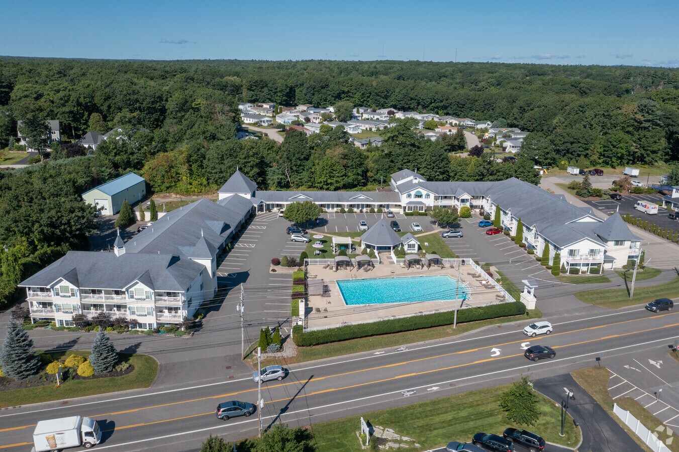
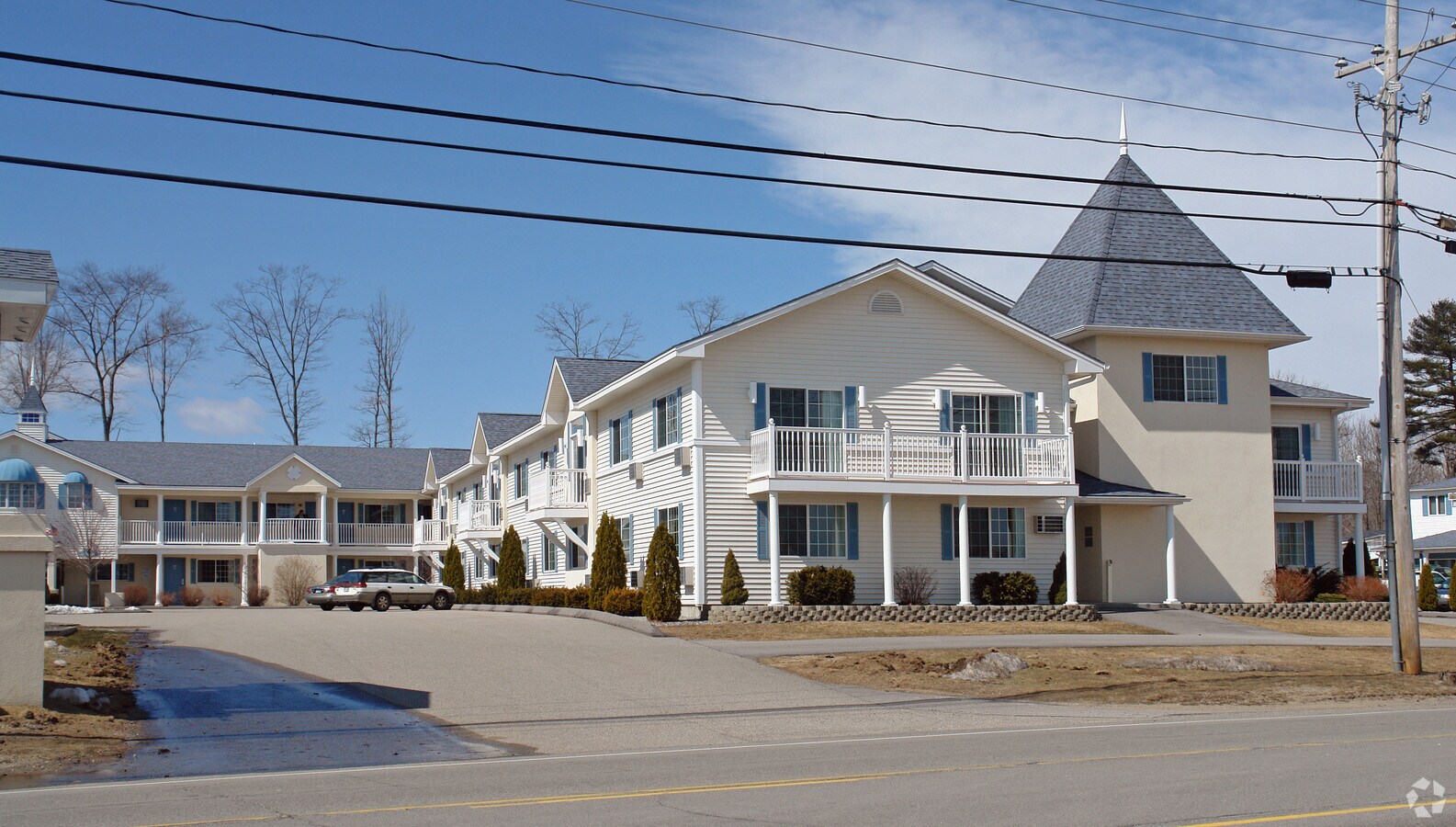
Property Record
719 Main St, Ogunquit, ME 03907

NEARBY LISTINGS FOR SALE OR LEASE
Property Detail
719 Main St
Portland-South Portland, ME
York
OGUN-000012-000000-000012
Maine
Commercialnec
12
2024
3.78 AC
2024
York County
034006
Portland/South Portland
DEMOGRAPHICS near 719 Main St
1 Mile
3 Mile
5 Mile
2024 Total Population
1,352
5,747
11,536
2029 Population
1,419
6,134
12,395
Pop Growth 2024-2029
+ 4.96%
+ 6.73%
+ 7.45%
Average Age
55
53
51
2024 Total Households
681
2,780
5,349
HH Growth 2024-2029
+ 4.70%
+ 6.62%
+ 7.42%
Median Household Inc
$80,512
$74,754
$76,342
Avg Household Size
2.00
2.10
2.10
2024 Avg HH Vehicles
2.00
2.00
2.00
Median Home Value
$545,203
$512,085
$455,948
Median Year Built
1985
1984
1986
Nearby Places
- Restaurants
- Banks
- Shops
- Fitness
- Groceries
PUBLIC TRANSPORTATION
COMMUTER RAIL
Wells (Downeaster - Amtrak)
DRIVE
WALK
Distance
Wells (Downeaster - Amtrak)
11 min
5.1 mi
AIRPORT
Portsmouth International at Pease
DRIVE
WALK
Distance
Portsmouth International at Pease
34 min
19.7 mi
Portland International Jetport
DRIVE
WALK
Distance
Portland International Jetport
45 min
33.2 mi
Freight Ports
Portland, ME
DRIVE
WALK
Distance
Portland, ME
46 min
35.8 mi
Nearby Properties
Address
Land Use
TOTAL SIZE
Lot Size
Zoning
Address
Land Use
TOTAL SIZE
Lot Size
Zoning
76,411 SF
84.80 AC
RA
Address
Land Use
TOTAL SIZE
Lot Size
Zoning
4.10 AC
LB/SLC
Address
Land Use
TOTAL SIZE
Lot Size
Zoning
4.64 AC
SLC/LB
Address
Land Use
TOTAL SIZE
Lot Size
Zoning
3.68 AC
SLC/GB
Address
Land Use
TOTAL SIZE
Lot Size
Zoning
2.63 AC
LBD/SL
Address
Land Use
TOTAL SIZE
Lot Size
Zoning
2,733 SF
45.48 AC
R
Address
Land Use
TOTAL SIZE
Lot Size
Zoning
1.49 AC
SGD-1
Address
Land Use
TOTAL SIZE
Lot Size
Zoning
1.29 AC
SLR
Address
Land Use
TOTAL SIZE
Lot Size
Zoning
4.65 AC
GBD2
Address
Land Use
TOTAL SIZE
Lot Size
Zoning
56,299 SF
5.03 AC
GB
Address
Land Use
TOTAL SIZE
Lot Size
Zoning
3.97 AC
GBD2
Address
Land Use
TOTAL SIZE
Lot Size
Zoning
38,083 SF
3.01 AC
GB
Address
Land Use
TOTAL SIZE
Lot Size
Zoning
1.11 AC
LBD
Address
Land Use
TOTAL SIZE
Lot Size
Zoning
5.65 AC
GBD2
Address
Land Use
TOTAL SIZE
Lot Size
Zoning
44,369 SF
19.28 AC
GB
Address
Land Use
TOTAL SIZE
Lot Size
Zoning
4.67 AC
GBD2/R
Address
Land Use
TOTAL SIZE
Lot Size
Zoning
2.38 AC
SGD-2
Address
Land Use
TOTAL SIZE
Lot Size
Zoning
400 SF
0.36 AC
GB02
Address
Land Use
TOTAL SIZE
Lot Size
Zoning
2,415 SF
44.88 AC
R
Address
Land Use
TOTAL SIZE
Lot Size
Zoning
31,080 SF
11.50 AC
EX
Address
Land Use
TOTAL SIZE
Lot Size
Zoning
13.33 AC
R1-6
Address
Land Use
TOTAL SIZE
Lot Size
Zoning
2.07 AC
SLC
Address
Land Use
TOTAL SIZE
Lot Size
Zoning
19,921 SF
0.79 AC
BB
Address
Land Use
TOTAL SIZE
Lot Size
Zoning
4,718 SF
2.38 AC
SLR
Address
Land Use
TOTAL SIZE
Lot Size
Zoning
1,496 SF
24.66 AC
GB
Address
Land Use
TOTAL SIZE
Lot Size
Zoning
142 AC
RP
Address
Land Use
TOTAL SIZE
Lot Size
Zoning
2,400 SF
15.03 AC
GB
Address
Land Use
TOTAL SIZE
Lot Size
Zoning
3.53 AC
SLC/GB
Address
Land Use
TOTAL SIZE
Lot Size
Zoning
1.43 AC
SLC
The World's #1 Commercial Real Estate Marketplace
Connect with us
© 2025 CoStar Group
The information above has been obtained from sources believed reliable. While we do not doubt its accuracy we have not verified it and make no guarantee, warranty or representation about it. It is your responsibility to independently confirm its accuracy and completeness. Any projections, opinions, assumptions, or estimates used are for example only and do not represent the current or future performance of the property. The value of this transaction to you depends on tax and other factors which should be evaluated by your tax, financial, and legal advisors. You and your advisors should conduct a careful, independent investigation of the property to determine to your satisfaction the suitability of the property for your needs.