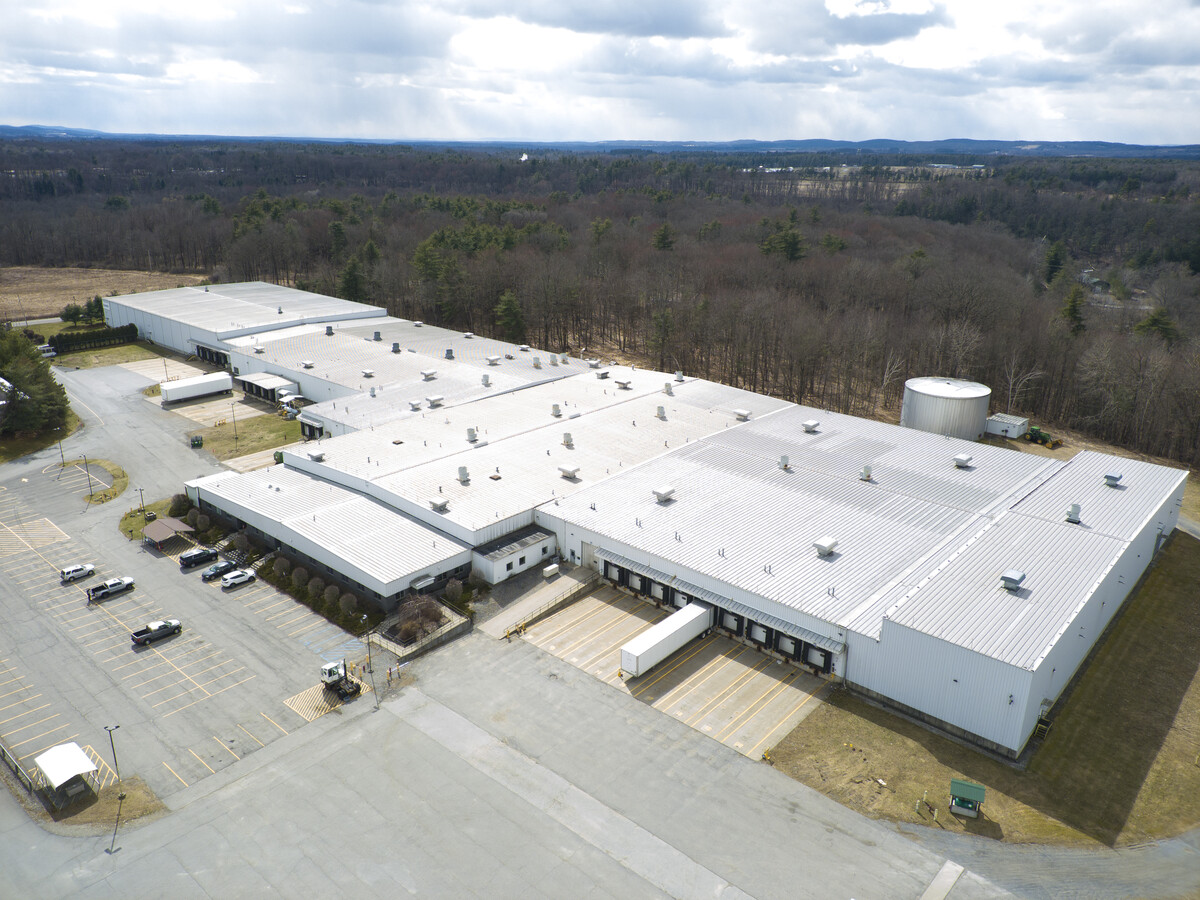
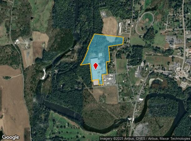
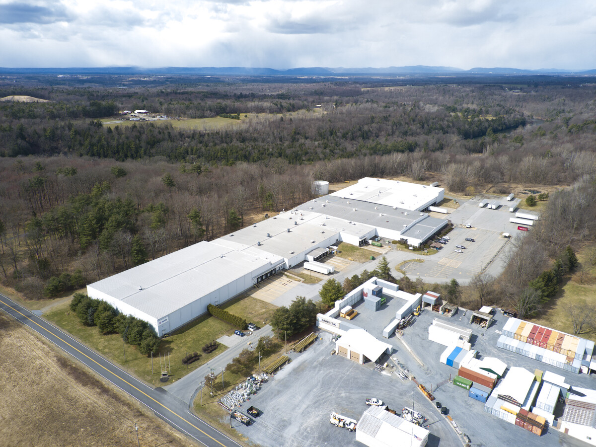
Property Record
72 County Route 53, Greenwich, NY 12834
This Property Is For Sale
Current Lease Availabilities
NEARBY LISTINGS FOR SALE OR LEASE
Property Detail
72 County Route 53
Glens Falls, NY
MANUFACTURING LEASE ASSIGN 838/148 LOT 3
533489-228-000-0001-003-000-0000
Washington
Manufacturinglight
New York
2024
3.000
2023
30.69 AC
089000
Washington County
176,860 SF
Albany/Schenectady/Troy
DEMOGRAPHICS near 72 County Route 53
1 Mile
3 Mile
5 Mile
2024 Total Population
633
5,428
8,418
2029 Population
621
5,399
8,397
Pop Growth 2024-2029
(1.90%)
(0.53%)
(0.25%)
Average Age
42
42
42
2024 Total Households
265
2,284
3,464
HH Growth 2024-2029
(1.89%)
(0.48%)
(0.26%)
Median Household Inc
$73,999
$72,284
$75,205
Avg Household Size
2.40
2.40
2.40
2024 Avg HH Vehicles
2.00
2.00
2.00
Median Home Value
$181,578
$190,887
$197,918
Median Year Built
1948
1948
1948
Nearby Places
- Restaurants
- Banks
- Shops
- Fitness
- Groceries
PUBLIC TRANSPORTATION
AIRPORT
Albany International
DRIVE
WALK
Distance
Albany International
54 min
34.0 mi
Freight Ports
Albany, NY Port
DRIVE
WALK
Distance
Albany, NY Port
62 min
38.0 mi
Nearby Properties
Address
Land Use
TOTAL SIZE
Lot Size
Zoning
Address
Land Use
TOTAL SIZE
Lot Size
Zoning
36,583 SF
30.10 AC
MDR
Address
Land Use
TOTAL SIZE
Lot Size
Zoning
38,146 SF
36.35 AC
CONF
Address
Land Use
TOTAL SIZE
Lot Size
Zoning
64,960 SF
80.70 AC
Address
Land Use
TOTAL SIZE
Lot Size
Zoning
4,716 SF
43.66 AC
Address
Land Use
TOTAL SIZE
Lot Size
Zoning
10,000 SF
42.26 AC
Address
Land Use
TOTAL SIZE
Lot Size
Zoning
1,980 SF
2.36 AC
07 - MIXED
Address
Land Use
TOTAL SIZE
Lot Size
Zoning
23,516 SF
9.80 AC
C
Address
Land Use
TOTAL SIZE
Lot Size
Zoning
63,072 SF
11.37 AC
Address
Land Use
TOTAL SIZE
Lot Size
Zoning
47,601 SF
19.82 AC
C
Address
Land Use
TOTAL SIZE
Lot Size
Zoning
2,043 SF
105.76 AC
N00
Address
Land Use
TOTAL SIZE
Lot Size
Zoning
16,843 SF
286.98 AC
N00
Address
Land Use
TOTAL SIZE
Lot Size
Zoning
Address
Land Use
TOTAL SIZE
Lot Size
Zoning
27,040 SF
9.52 AC
Address
Land Use
TOTAL SIZE
Lot Size
Zoning
768 SF
45.40 AC
HMU
Address
Land Use
TOTAL SIZE
Lot Size
Zoning
29,640 SF
17.53 AC
Address
Land Use
TOTAL SIZE
Lot Size
Zoning
52,020 SF
4.80 AC
HMU
Address
Land Use
TOTAL SIZE
Lot Size
Zoning
32,500 SF
15.38 AC
C
Address
Land Use
TOTAL SIZE
Lot Size
Zoning
24,154 SF
5.32 AC
C
Address
Land Use
TOTAL SIZE
Lot Size
Zoning
4,900 SF
67.80 AC
Address
Land Use
TOTAL SIZE
Lot Size
Zoning
13,316 SF
1.55 AC
CONF
Address
Land Use
TOTAL SIZE
Lot Size
Zoning
22,272 SF
0.57 AC
Address
Land Use
TOTAL SIZE
Lot Size
Zoning
9,761 SF
7.40 AC
R
Address
Land Use
TOTAL SIZE
Lot Size
Zoning
30,502 SF
3.77 AC
MDR
Address
Land Use
TOTAL SIZE
Lot Size
Zoning
Address
Land Use
TOTAL SIZE
Lot Size
Zoning
28,916 SF
170.25 AC
Address
Land Use
TOTAL SIZE
Lot Size
Zoning
18,750 SF
2.30 AC
C
Address
Land Use
TOTAL SIZE
Lot Size
Zoning
7,500 SF
4.50 AC
Address
Land Use
TOTAL SIZE
Lot Size
Zoning
13,467 SF
2.50 AC
MDR01
Address
Land Use
TOTAL SIZE
Lot Size
Zoning
15,096 SF
5.40 AC
The World's #1 Commercial Real Estate Marketplace
Connect with us
© 2025 CoStar Group
The information above has been obtained from sources believed reliable. While we do not doubt its accuracy we have not verified it and make no guarantee, warranty or representation about it. It is your responsibility to independently confirm its accuracy and completeness. Any projections, opinions, assumptions, or estimates used are for example only and do not represent the current or future performance of the property. The value of this transaction to you depends on tax and other factors which should be evaluated by your tax, financial, and legal advisors. You and your advisors should conduct a careful, independent investigation of the property to determine to your satisfaction the suitability of the property for your needs.