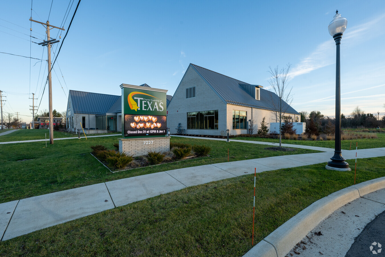
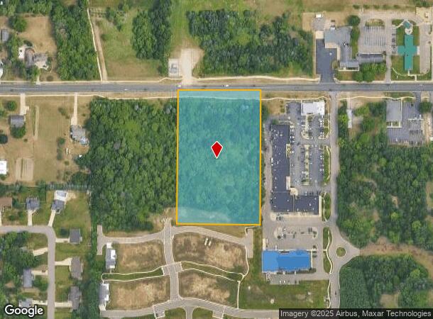
Property Record
7227 W Q Ave, Kalamazoo, MI 49009

NEARBY LISTINGS FOR SALE OR LEASE
-
-
View all Kalamazoo listings for sale on LoopNet.com
Property Detail
7227 W Q Ave
09-22-226-006
SEC 23-3-12 BEG ON N LI 1364.04 FT S 89DEG-15'-50" E OF N 1/4 POST TH S 89DEG-15'-50" W ALG N LI 338.85 FT TH S 01DEG-23'-00"
Commercialacreage
Kalamazoo
X
Michigan
26077C0300E
4.27 AC
2021
Southern Kalamazoo County
2024
West Michigan
0030033002
Kalamazoo-Portage, MI
DEMOGRAPHICS near 7227 W Q Ave
1 Mile
3 Mile
5 Mile
2024 Total Population
2,964
16,678
53,068
2029 Population
2,964
16,603
52,813
Pop Growth 2024-2029
0.00%
(0.45%)
(0.48%)
Average Age
38
39
39
2024 Total Households
1,022
5,932
20,910
HH Growth 2024-2029
0.00%
(0.52%)
(0.55%)
Median Household Inc
$134,911
$126,564
$88,901
Avg Household Size
2.90
2.80
2.50
2024 Avg HH Vehicles
2.00
2.00
2.00
Median Home Value
$340,697
$339,643
$268,953
Median Year Built
2000
1994
1987
Nearby Places
- Restaurants
- Banks
- Shops
- Fitness
- Groceries
PUBLIC TRANSPORTATION
AIRPORT
Kalamazoo/Battle Creek International
DRIVE
WALK
Distance
Kalamazoo/Battle Creek International
22 min
10.7 mi
Freight Ports
Port of Toledo
DRIVE
WALK
Distance
Port of Toledo
186 min
152.2 mi
Nearby Properties
Address
Land Use
TOTAL SIZE
Lot Size
Zoning
Address
Land Use
TOTAL SIZE
Lot Size
Zoning
424,967 SF
55.60 AC
I-1
Address
Land Use
TOTAL SIZE
Lot Size
Zoning
140,000 SF
22.69 AC
EBT
Address
Land Use
TOTAL SIZE
Lot Size
Zoning
16.75 AC
CBD
Address
Land Use
TOTAL SIZE
Lot Size
Zoning
4.33 AC
C-1
Address
Land Use
TOTAL SIZE
Lot Size
Zoning
60,392 SF
13.20 AC
Address
Land Use
TOTAL SIZE
Lot Size
Zoning
92,694 SF
16.10 AC
EBT
Address
Land Use
TOTAL SIZE
Lot Size
Zoning
7.57 AC
Address
Land Use
TOTAL SIZE
Lot Size
Zoning
226,877 SF
20.48 AC
I-1
Address
Land Use
TOTAL SIZE
Lot Size
Zoning
44,038 SF
6.50 AC
CBD
Address
Land Use
TOTAL SIZE
Lot Size
Zoning
1,489 SF
7.79 AC
R-1T
Address
Land Use
TOTAL SIZE
Lot Size
Zoning
14.38 AC
I-1
Address
Land Use
TOTAL SIZE
Lot Size
Zoning
80,550 SF
11.02 AC
R-5
Address
Land Use
TOTAL SIZE
Lot Size
Zoning
8.83 AC
I-1
Address
Land Use
TOTAL SIZE
Lot Size
Zoning
192,081 SF
27.50 AC
EBT
Address
Land Use
TOTAL SIZE
Lot Size
Zoning
38.51 AC
R-6
Address
Land Use
TOTAL SIZE
Lot Size
Zoning
99,400 SF
7.39 AC
I-1
Address
Land Use
TOTAL SIZE
Lot Size
Zoning
20,600 SF
3.12 AC
PD
Address
Land Use
TOTAL SIZE
Lot Size
Zoning
21,940 SF
8.30 AC
OS-1
Address
Land Use
TOTAL SIZE
Lot Size
Zoning
45,322 SF
3.75 AC
C-1
Address
Land Use
TOTAL SIZE
Lot Size
Zoning
15,883 SF
2.99 AC
Address
Land Use
TOTAL SIZE
Lot Size
Zoning
14,518 SF
2.94 AC
CBD
Address
Land Use
TOTAL SIZE
Lot Size
Zoning
29,709 SF
1.73 AC
C-4
Address
Land Use
TOTAL SIZE
Lot Size
Zoning
9,000 SF
5.25 AC
Address
Land Use
TOTAL SIZE
Lot Size
Zoning
26.16 AC
R-6
Address
Land Use
TOTAL SIZE
Lot Size
Zoning
73,599 SF
14.98 AC
I-1
Address
Land Use
TOTAL SIZE
Lot Size
Zoning
30,424 SF
1.62 AC
C-4
Address
Land Use
TOTAL SIZE
Lot Size
Zoning
10,125 SF
6.70 AC
I-1
Address
Land Use
TOTAL SIZE
Lot Size
Zoning
6,500 SF
3.36 AC
Address
Land Use
TOTAL SIZE
Lot Size
Zoning
79,550 SF
8.16 AC
I-1
Address
Land Use
TOTAL SIZE
Lot Size
Zoning
5,426 SF
1 AC
The World's #1 Commercial Real Estate Marketplace
Connect with us
© 2025 CoStar Group
The information above has been obtained from sources believed reliable. While we do not doubt its accuracy we have not verified it and make no guarantee, warranty or representation about it. It is your responsibility to independently confirm its accuracy and completeness. Any projections, opinions, assumptions, or estimates used are for example only and do not represent the current or future performance of the property. The value of this transaction to you depends on tax and other factors which should be evaluated by your tax, financial, and legal advisors. You and your advisors should conduct a careful, independent investigation of the property to determine to your satisfaction the suitability of the property for your needs.