Property Record
7230 Beth Bath Pike, Bath, PA 18014
NEARBY LISTINGS FOR SALE OR LEASE
Property Detail
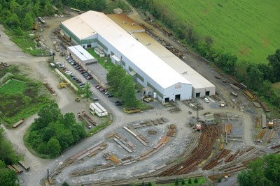
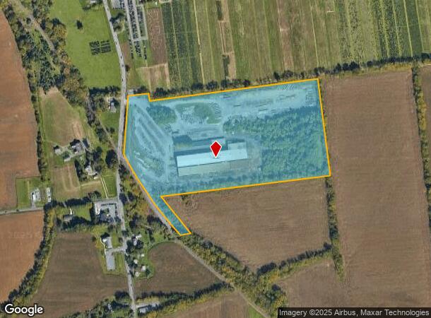
7230 Beth Bath Pike
Manufacturinglight
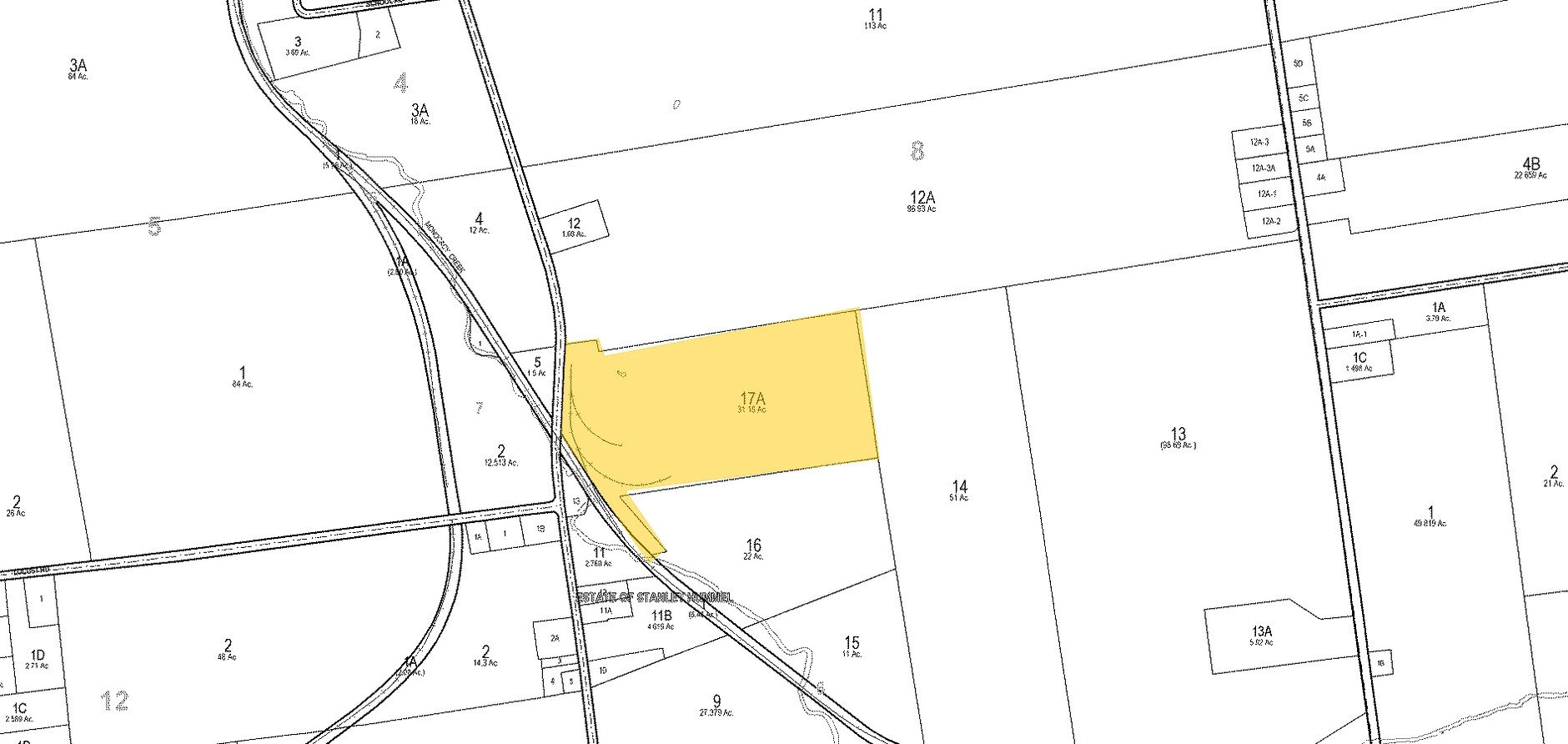
Northampton
A
Pennsylvania
42095C0235E
31.18 AC
2024
Lehigh Valley
2024
Philadelphia
015901
Allentown-Bethlehem-Easton, PA-NJ
59,090 SF
L6-8-17A-0508
DEMOGRAPHICS near 7230 Beth Bath Pike
1 Mile
3 Mile
5 Mile
2024 Total Population
890
24,902
96,791
2029 Population
925
25,143
97,530
Pop Growth 2024-2029
+ 3.93%
+ 0.97%
+ 0.76%
Average Age
43
45
44
2024 Total Households
316
9,176
37,595
HH Growth 2024-2029
+ 3.80%
+ 0.87%
+ 0.68%
Median Household Inc
$107,012
$95,320
$84,378
Avg Household Size
2.80
2.60
2.40
2024 Avg HH Vehicles
2.00
2.00
2.00
Median Home Value
$350,000
$324,027
$270,245
Median Year Built
1990
1985
1973
Nearby Places
- Restaurants
- Banks
- Shops
- Fitness
- Groceries
PUBLIC TRANSPORTATION
AIRPORT
Lehigh Valley International
DRIVE
WALK
Distance
Lehigh Valley International
12 min
5.8 mi
Freight Ports
Port of Philadelphia
DRIVE
WALK
Distance
Port of Philadelphia
95 min
71.6 mi
Nearby Properties
Address
Land Use
TOTAL SIZE
Lot Size
Zoning
Address
Land Use
TOTAL SIZE
Lot Size
Zoning
605,906 SF
94.28 AC
A
Address
Land Use
TOTAL SIZE
Lot Size
Zoning
302,378 SF
83.53 AC
A
Address
Land Use
TOTAL SIZE
Lot Size
Zoning
452,012 SF
40.39 AC
PC
Address
Land Use
TOTAL SIZE
Lot Size
Zoning
276,484 SF
31.19 AC
A
Address
Land Use
TOTAL SIZE
Lot Size
Zoning
298,660 SF
37.43 AC
PIBD
Address
Land Use
TOTAL SIZE
Lot Size
Zoning
533,165 SF
54.66 AC
LI/BP
Address
Land Use
TOTAL SIZE
Lot Size
Zoning
524,948 SF
35.66 AC
LI
Address
Land Use
TOTAL SIZE
Lot Size
Zoning
512,902 SF
35.18 AC
LI
Address
Land Use
TOTAL SIZE
Lot Size
Zoning
601,903 SF
41.68 AC
LI
Address
Land Use
TOTAL SIZE
Lot Size
Zoning
539,133 SF
47 AC
LI
Address
Land Use
TOTAL SIZE
Lot Size
Zoning
1,456 SF
29.36 AC
A
Address
Land Use
TOTAL SIZE
Lot Size
Zoning
42,465 SF
7.28 AC
LI
Address
Land Use
TOTAL SIZE
Lot Size
Zoning
437,612 SF
42.26 AC
LI/BP
Address
Land Use
TOTAL SIZE
Lot Size
Zoning
508,835 SF
34.92 AC
A
Address
Land Use
TOTAL SIZE
Lot Size
Zoning
244,478 SF
26.32 AC
LI
Address
Land Use
TOTAL SIZE
Lot Size
Zoning
307,425 SF
37.13 AC
A
Address
Land Use
TOTAL SIZE
Lot Size
Zoning
32.25 AC
PC
Address
Land Use
TOTAL SIZE
Lot Size
Zoning
109,753 SF
15.33 AC
PIBD
Address
Land Use
TOTAL SIZE
Lot Size
Zoning
294,412 SF
28.72 AC
A
Address
Land Use
TOTAL SIZE
Lot Size
Zoning
284,079 SF
20.65 AC
A
Address
Land Use
TOTAL SIZE
Lot Size
Zoning
106,155 SF
11.80 AC
RIS
Address
Land Use
TOTAL SIZE
Lot Size
Zoning
257,186 SF
14.63 AC
G1
Address
Land Use
TOTAL SIZE
Lot Size
Zoning
201,145 SF
37.93 AC
LI
Address
Land Use
TOTAL SIZE
Lot Size
Zoning
120,359 SF
22.49 AC
R1S
Address
Land Use
TOTAL SIZE
Lot Size
Zoning
229,448 SF
12.95 AC
GI
Address
Land Use
TOTAL SIZE
Lot Size
Zoning
312,950 SF
33.17 AC
A
Address
Land Use
TOTAL SIZE
Lot Size
Zoning
227,807 SF
12.09 AC
GI
Address
Land Use
TOTAL SIZE
Lot Size
Zoning
124,855 SF
6.14 AC
RIS
Address
Land Use
TOTAL SIZE
Lot Size
Zoning
48,894 SF
34.10 AC
EI
Address
Land Use
TOTAL SIZE
Lot Size
Zoning
207,393 SF
15.28 AC
LI
The World's #1 Commercial Real Estate Marketplace
Connect with us
© 2025 CoStar Group
The information above has been obtained from sources believed reliable. While we do not doubt its accuracy we have not verified it and make no guarantee, warranty or representation about it. It is your responsibility to independently confirm its accuracy and completeness. Any projections, opinions, assumptions, or estimates used are for example only and do not represent the current or future performance of the property. The value of this transaction to you depends on tax and other factors which should be evaluated by your tax, financial, and legal advisors. You and your advisors should conduct a careful, independent investigation of the property to determine to your satisfaction the suitability of the property for your needs.