Property Record
7272 Harmony Square Dr E, Harmony, FL 34773
NEARBY LISTINGS FOR SALE OR LEASE
Property Detail
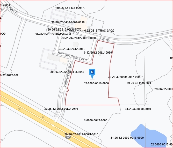
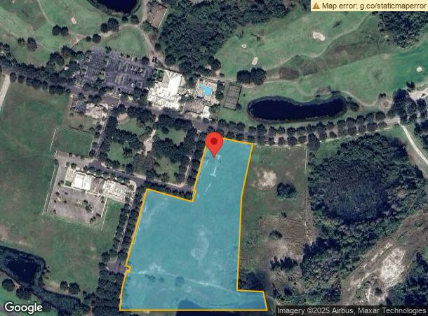
7272 Harmony Square Dr E
Orlando-Kissimmee-Sanford, FL
St Cloud Hwy East
30-26-32-0000-0016-0000
COM AT SE COR OF UTILITY TRACT 1, BIRCHWOOD NBHD B & C PB 14 PGS 67-73, N 30 DEG E 49.30 FT, N 60 DEG W 69.96 FT TO POB; CONT N 60 DEG W 544.05 FT TO NON-TAN CURVE, CONC W, RAD 351 FT, CENT ANG 27 DEG, (CH BEARING N 14 DEG E 166.64 FT), NLY ALONG CUR
Commercialacreage
Osceola
X
Florida
12097C0285G
8.65 AC
2023
Osceola Outlying
2024
Orlando
043802
DEMOGRAPHICS near 7272 Harmony Square Dr E
1 Mile
3 Mile
5 Mile
2024 Total Population
2,405
5,643
8,850
2029 Population
3,003
7,029
10,907
Pop Growth 2024-2029
+ 24.86%
+ 24.56%
+ 23.24%
Average Age
36
36
38
2024 Total Households
740
1,755
2,921
HH Growth 2024-2029
+ 24.73%
+ 24.39%
+ 22.94%
Median Household Inc
$79,927
$79,677
$76,570
Avg Household Size
3.20
3.20
3.00
2024 Avg HH Vehicles
2.00
2.00
2.00
Median Home Value
$327,719
$330,285
$342,026
Median Year Built
2011
2011
2010
Nearby Places
- Restaurants
- Banks
- Shops
- Fitness
- Groceries
PUBLIC TRANSPORTATION
AIRPORT
Orlando International
DRIVE
WALK
Distance
Orlando International
44 min
28.6 mi
Freight Ports
Port Canaveral
DRIVE
WALK
Distance
Port Canaveral
78 min
63.7 mi
Nearby Properties
Address
Land Use
TOTAL SIZE
Lot Size
Zoning
Address
Land Use
TOTAL SIZE
Lot Size
Zoning
229,148 SF
47.05 AC
OAC
Address
Land Use
TOTAL SIZE
Lot Size
Zoning
121,656 SF
9.49 AC
OPD
Address
Land Use
TOTAL SIZE
Lot Size
Zoning
19,606 SF
100.40 AC
OAC
Address
Land Use
TOTAL SIZE
Lot Size
Zoning
28,429 SF
263.30 AC
OAC
Address
Land Use
TOTAL SIZE
Lot Size
Zoning
1,647 SF
59.67 AC
OAC
Address
Land Use
TOTAL SIZE
Lot Size
Zoning
79.35 AC
Address
Land Use
TOTAL SIZE
Lot Size
Zoning
15,040 SF
5.13 AC
OPD
Address
Land Use
TOTAL SIZE
Lot Size
Zoning
Address
Land Use
TOTAL SIZE
Lot Size
Zoning
9.80 AC
Address
Land Use
TOTAL SIZE
Lot Size
Zoning
12,430 SF
3.02 AC
OPD
Address
Land Use
TOTAL SIZE
Lot Size
Zoning
189.70 AC
Address
Land Use
TOTAL SIZE
Lot Size
Zoning
3,290 SF
1.60 AC
OPD
Address
Land Use
TOTAL SIZE
Lot Size
Zoning
16,500 SF
2.80 AC
OPD
Address
Land Use
TOTAL SIZE
Lot Size
Zoning
10,348 SF
326.84 AC
OAC
Address
Land Use
TOTAL SIZE
Lot Size
Zoning
253.20 AC
OAC
Address
Land Use
TOTAL SIZE
Lot Size
Zoning
60.69 AC
AC
Address
Land Use
TOTAL SIZE
Lot Size
Zoning
33,933 SF
13.54 AC
Address
Land Use
TOTAL SIZE
Lot Size
Zoning
5,951 SF
0.28 AC
OPD
Address
Land Use
TOTAL SIZE
Lot Size
Zoning
6.62 AC
OPD
Address
Land Use
TOTAL SIZE
Lot Size
Zoning
Address
Land Use
TOTAL SIZE
Lot Size
Zoning
4.39 AC
Address
Land Use
TOTAL SIZE
Lot Size
Zoning
20.05 AC
OAC
Address
Land Use
TOTAL SIZE
Lot Size
Zoning
19.48 AC
OAC
Address
Land Use
TOTAL SIZE
Lot Size
Zoning
Address
Land Use
TOTAL SIZE
Lot Size
Zoning
2,354 SF
22.46 AC
OAC
Address
Land Use
TOTAL SIZE
Lot Size
Zoning
Address
Land Use
TOTAL SIZE
Lot Size
Zoning
96.60 AC
OPUD
Address
Land Use
TOTAL SIZE
Lot Size
Zoning
103.15 AC
OPUD
The World's #1 Commercial Real Estate Marketplace
Connect with us
© 2025 CoStar Group
The information above has been obtained from sources believed reliable. While we do not doubt its accuracy we have not verified it and make no guarantee, warranty or representation about it. It is your responsibility to independently confirm its accuracy and completeness. Any projections, opinions, assumptions, or estimates used are for example only and do not represent the current or future performance of the property. The value of this transaction to you depends on tax and other factors which should be evaluated by your tax, financial, and legal advisors. You and your advisors should conduct a careful, independent investigation of the property to determine to your satisfaction the suitability of the property for your needs.