Property Record
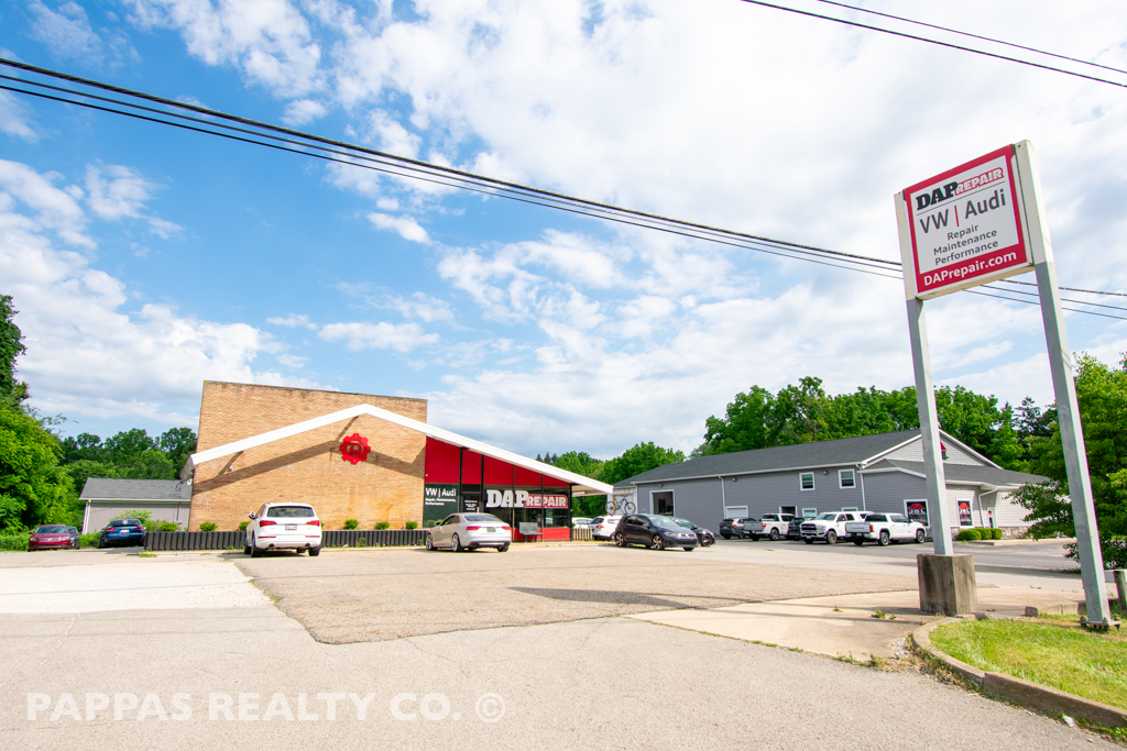
7279 State Route 43, Kent, OH 44240


NEARBY LISTINGS FOR SALE OR LEASE
Property Detail
7279 State Route 43
Akron, OH
Franklin
12-068-00-00-016-000
LOT 68
Autorepair
Portage
X
Ohio
39133C0128D
68
2023
0.65 AC
2023
Portage County
601600
Cleveland
1,536 SF
DEMOGRAPHICS near 7279 State Route 43
1 Mile
3 Mile
5 Mile
2024 Total Population
1,231
27,736
83,966
2029 Population
1,247
28,043
84,700
Pop Growth 2024-2029
+ 1.30%
+ 1.11%
+ 0.87%
Average Age
47
36
39
2024 Total Households
506
10,726
34,378
HH Growth 2024-2029
+ 1.19%
+ 1.48%
+ 1.04%
Median Household Inc
$136,141
$54,379
$64,692
Avg Household Size
2.30
2.20
2.20
2024 Avg HH Vehicles
2.00
2.00
2.00
Median Home Value
$261,918
$233,547
$207,725
Median Year Built
1963
1974
1976
Nearby Places
- Restaurants
- Banks
- Shops
- Fitness
- Groceries
PUBLIC TRANSPORTATION
AIRPORT
Akron-Canton Regional
DRIVE
WALK
Distance
Akron-Canton Regional
38 min
26.6 mi
Freight Ports
Port of Toledo
DRIVE
WALK
Distance
Port of Toledo
162 min
135.9 mi
SALE & LEASE HISTORY
LISTING DATE
SALE/LEASE

Jan 11, 2022
For Sale
Nearby Properties
Address
Land Use
TOTAL SIZE
Lot Size
Zoning
Address
Land Use
TOTAL SIZE
Lot Size
Zoning
713,426 SF
405.90 AC
Address
Land Use
TOTAL SIZE
Lot Size
Zoning
317,146 SF
86.98 AC
Address
Land Use
TOTAL SIZE
Lot Size
Zoning
183,977 SF
10.12 AC
Address
Land Use
TOTAL SIZE
Lot Size
Zoning
86,411 SF
0.23 AC
Address
Land Use
TOTAL SIZE
Lot Size
Zoning
141,562 SF
1.63 AC
Address
Land Use
TOTAL SIZE
Lot Size
Zoning
117,571 SF
119.98 AC
Address
Land Use
TOTAL SIZE
Lot Size
Zoning
150,616 SF
12.63 AC
Address
Land Use
TOTAL SIZE
Lot Size
Zoning
28,438 SF
9 AC
Address
Land Use
TOTAL SIZE
Lot Size
Zoning
310,705 SF
9.96 AC
Address
Land Use
TOTAL SIZE
Lot Size
Zoning
78,446 SF
18.02 AC
Address
Land Use
TOTAL SIZE
Lot Size
Zoning
52,575 SF
1.33 AC
Address
Land Use
TOTAL SIZE
Lot Size
Zoning
89,449 SF
14.59 AC
Address
Land Use
TOTAL SIZE
Lot Size
Zoning
34,394 SF
3.59 AC
Address
Land Use
TOTAL SIZE
Lot Size
Zoning
176,320 SF
1.72 AC
Address
Land Use
TOTAL SIZE
Lot Size
Zoning
33,561 SF
2.62 AC
Address
Land Use
TOTAL SIZE
Lot Size
Zoning
73,306 SF
0.78 AC
Address
Land Use
TOTAL SIZE
Lot Size
Zoning
8.12 AC
Address
Land Use
TOTAL SIZE
Lot Size
Zoning
63,288 SF
0.88 AC
Address
Land Use
TOTAL SIZE
Lot Size
Zoning
24,210 SF
2.34 AC
Address
Land Use
TOTAL SIZE
Lot Size
Zoning
23,668 SF
2.32 AC
Address
Land Use
TOTAL SIZE
Lot Size
Zoning
158,600 SF
11.30 AC
Address
Land Use
TOTAL SIZE
Lot Size
Zoning
48,779 SF
0.55 AC
Address
Land Use
TOTAL SIZE
Lot Size
Zoning
43,705 SF
0.36 AC
Address
Land Use
TOTAL SIZE
Lot Size
Zoning
63,664 SF
8.15 AC
Address
Land Use
TOTAL SIZE
Lot Size
Zoning
84,265 SF
11.11 AC
Address
Land Use
TOTAL SIZE
Lot Size
Zoning
148,550 SF
21.86 AC
Address
Land Use
TOTAL SIZE
Lot Size
Zoning
38,025 SF
0.21 AC
Address
Land Use
TOTAL SIZE
Lot Size
Zoning
46,232 SF
10.16 AC
Address
Land Use
TOTAL SIZE
Lot Size
Zoning
31,792 SF
2.08 AC
Address
Land Use
TOTAL SIZE
Lot Size
Zoning
37,272 SF
4.65 AC
The World's #1 Commercial Real Estate Marketplace
Connect with us
© 2025 CoStar Group
The information above has been obtained from sources believed reliable. While we do not doubt its accuracy we have not verified it and make no guarantee, warranty or representation about it. It is your responsibility to independently confirm its accuracy and completeness. Any projections, opinions, assumptions, or estimates used are for example only and do not represent the current or future performance of the property. The value of this transaction to you depends on tax and other factors which should be evaluated by your tax, financial, and legal advisors. You and your advisors should conduct a careful, independent investigation of the property to determine to your satisfaction the suitability of the property for your needs.